


By clicking "ACCEPT", you agree to be the terms and conditions of each policy linked to above. You also agree to the storing of cookies on your device to facilitate the operation and functionality of our site, enhance and customize your user experience, and to analyze how our site is used.
Florida Off-Road Trails
135
Total Trail Guides 130

910
Detailed Waypoints 15
Try a Free 7-Day Trial and unlock it all
Start a Free Trial Most Recent Trail Reviews
Rated 2/5
Open
Visited: 07/18/2026
Should be considered a level 1 trail. No obstacles, no hazards—basically a road leading to other trails.
N
nick
N
nick
Rated 5/5
Open
Visited: 06/20/2026
Drove the trail when there has not been a lot of rain. Would not do this trail after heavy rains or during the rainy season. There are bypasses for the deep mud holes but some there was not. Fun trai...
Richard
Rated 2/5
Open
Visited: 06/13/2026
Drove FR 66 from FR 21 to FR 41, the portion we drove is hard packed almost like a paved road. This will be no problem for a 2wd vehicle.
CC
Chris Costine
Rated 2/5
Open
Visited: 06/13/2026
Ran full length of the trail from FR 66 to FR 29. Soft sand in multiple areas and there are spots that can hold water but are dry right now. Airing down will probably be useful. The trail gets tight i...
CC
Chris Costine
Rated 5/5
Open
Visited: 06/07/2026
Great trail, I would use caution during the rainy season. Some obstacles right off the trail if you choose to do them. I will be back to complete the trail again.
Richard
Rated 3/5
Open
Visited: 06/07/2026
We ran this trail from south to north. We encountered several areas of soft sand and put the truck into 4h as a precaution. A 2wd vehicle may have problems in the sandy areas. A nice drive, but I wou...
CC
Chris Costine
Rated 2/5
Open
Visited: 06/07/2026
Ran the trail from the intersection of Center and South Grades back out to SR471. A hard packed, pavement like trail that can be completed in any vehicle. No problems running this trail. All the camps...
CC
Chris Costine
Rated 2/5
Open
Visited: 06/07/2026
Ran the trail from SR 471, it's so hard packed that it's like a paved road, (as noted in a previous comment, we saw skid marks) other than some potholes to dodge, it's an easy trail that any vehicle c...
CC
Chris Costine
Rated 4/5
Open
Visited: 02/21/2026
A peaceful trail with some tight spaces resulting in some pinstriping. Beautiful scenery but sadly a ton of trash along the trails. I live at the coast and drive on the beach so the sugar sand was no ...
Heidi Powers
No Rating
Open
Visited: 02/15/2026
Did this trail during dry season, and it was moderately easy without any real standing water and only a few muddy holes. We could definitely see where this gets a lot of standing water the rest of the...
GK
Greg Kasson
Rated 4/5
Open
Visited: 02/14/2026
Nice trail, nothing to hard and a fun drive. Pinstripes are unavailable but will buff out. The two track trail on wide gas line sections are a fun drive is the soft sand.
BW
Bill Wrye
Rated 1/5
Open
Visited: 02/14/2026
We ran Tr 10 from west to east from Tr 17 to Tr 5. It’s very dry at the moment. The clay is hard packed and the east end by Holder Mine Campground is paved. A very easy drive that can be done in its e...
CC
Chris Costine
No Rating
Open
Visited: 02/14/2026
My wife and I ran the trail from north to south. The trail is very dry and sandy with no standing water. We ran it in a stock ‘25 Ford Ranger with stock tires and had no problems using only 4H. The sa...
CC
Chris Costine
No Rating
Open
Visited: 02/14/2026
The wife and I ran the trail from east to west in a stock ‘25 Ford Ranger with stock tires. We left from Mutual Mine Campground,and once I thought I needed 4wd I put the truck in 4H and didn’t need an...
CC
Chris Costine
No Rating
Open
Visited: 02/13/2026
We connected onto this trail from Graveyard Road. Started easy and then we found mud hole after mud hole. All obstacles/mud had easier bypasses available. Of course we all challenged each other (3 Je...
BR
Brian Rourke
No Rating
Open
Visited: 02/13/2026
A group of us (3 Jeeps and a Chevy Colorado) ran this and water holes were dry. Lots of soft sand and scenery and we were in 2wd for almost all of it. Serious drought conditions currently. We connect...
BR
Brian Rourke
No Rating
Open
Visited: 01/03/2026
Trail is very dry, and hard packed but has some potholes that are easily avoided. We ran it from Rodman to CR316 in a stock 2025 Ford Ranger and never had a need for 4wd. We encountered only one other...
CC
Chris Costine
Rated 4/5
Open
Visited: 12/30/2025
Lots of deep … really deep at times mud holes. I needed lockers on and sent it through one tough one however most spots did have go arounds and these were usually much better than the hole….
All this ...
MT
Michael Thrasher
Rated 5/5
Open
Visited: 12/20/2025
Excellent trail, went in a 2019 F250 Longbed FX4 with a leveling kit during dry season and had no issues. Just pay attention to the ruts and make sure to take the dips at speed if you’re in something ...


MM
Michael mena
No Rating
Open
Visited: 11/28/2025
Don’t run this trail if you care about your paint. Great trail but it is just miles and miles on limbs scratching down the side of your rig. I had to run it since it is the only Jeep badge of honor tr...

Gary Retherford

Trails Offroad
Trails Offroad
Trails Offroad
Rated 5/5
Open
Visited: 09/28/2025
Started at 11b running S. to N. Long wheel 4x4 base trucks won’t have a problem. Street tires not recommended due to the soft sand areas. Glad I have Grapplers.
RS
Red Saul
Rated 3/5
Open
Visited: 08/30/2025
Toured this as part of a “Sunday drive” with the Florida Trailstompers club. The general store was a cool stop.
GK
Greg Kasson
Rated 2/5
Open
Visited: 07/26/2025
This should be moderate at best but only after a good rain because it floods more. This is not technical by any means and just need to what out for branches that block the road.
A
Angelo
Rated 1/5
Open
Visited: 07/26/2025
Not sure why is this marked as moderate. it's a sand/gravel road that leads you to other trails.
A
Angelo
Rated 1/5
Open
Visited: 07/26/2025
Just an limestone access road that brings you into the Forrest. One step below a paved road.
A
Angelo
No Rating
Open
Visited: 07/14/2025
We did trail 9 yesterday morning and stopped for lunch at Essex Seafood. Trail was super dry and dusty, but we did see this bear kind of saunter across the road.

SM
Steven Morin
Rated 2/5
Open
Visited: 07/06/2025
PINSTRIPES! Several miles of this trail are too narrow to escape without significant pinstriping. The other reviewers are not exaggerating. Sections are so narrow that your Jeep will be pushing its...
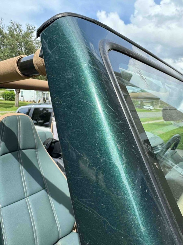

BJ
B Johnson
No Rating
Open
Visited: 06/14/2025
The trail is more like a paved road. You can see skid marks on the road. It also appeared that someone had used the road as a dumping ground. Much easier than the site state. I would give it a 1 a...

Patrick McDougle
Rated 4/5
Open
Visited: 06/14/2025
Nice Drive. The road is "paved". It can be easily done in a two-wheeled car.
Patrick McDougle

Peter S
No Rating
Open
Visited: 06/06/2025
Definitely tight in spots and you’ll appreciate that high pitched whine as the scrub oak and pine branches introduce themselves to your doors and fenders. Sugar sand and waters not a problem if you’ve...

Charles Costigan
Rated 4/5
Open
Visited: 06/04/2025
Like a lot of people have stated there is a LOT of single track pinstripe sections. The trail takes you through a lot of the NF and you come across some cool scenery. There are some cool POIs along ...


Aaron Bordeau
Rated 4/5
Open
Visited: 06/01/2025
This trail has some mud holes that can easily get you stuck even with high clearance 4x4. The official reporting of this is stated as easier than it actually is. I think it should at least be a 4 or 5...


MC
Michael Cummings

RANDALL DURKEE
No Rating
Partially Open
Visited: 05/16/2025
Bridge still closed, can use Fish Hole trail as a bypass.
RANDALL DURKEE
No Rating
Open
Visited: 05/10/2025
Highlight of this trail is the open area before waypoint 4 which has monoliths of sand. Not sure why they are there but locals use them as shooting backstops and to test out their swaybar disconnect

JB
James Barna
Rated 4/5
Partially Open
Visited: 05/10/2025
Trail 15 is closed between waypoints one and two . There are two closed signs at waypoint #1 heading north and one shotgun peppered closed sign heading south at waypoint #2 . Pictured below. For tho...


JB
James Barna
No Rating
Open
Visited: 04/29/2025
Did from N to S the whole Trail 11 and 11b. It was very dry with no water in any hole besides one of the worst holes. I did get a little pinstripes on my roof and sides even in my mid-size Ranger. Som...

Eric Keatley

Joseph Thomas
Rated 4/5
Open
Visited: 04/26/2025
Dry season and hasn't rained a weeks around my place. trails are dry and dusty. trail 15 is pleasant trail with lots of diversity. thick sand in places, a couple of clay washes that provide some off c...


MT
Michael Thrasher
Rated 3/5
Open
Visited: 04/19/2025
Very tight with pinstriping especially up until waypoint 25 or so. A few areas of deep sand but nothing too difficult. Did mopst of teh trail in 2WD with exception of a couple of teh deeper sand areas...


MT
Michael Thrasher
No Rating
Partially Open
Visited: 04/17/2025
About a 1/3 of the way on the trail heading north to south experienced a downed tree about 4’ off the ground across the trail.
RANDALL DURKEE
Rated 5/5
Open
Visited: 04/02/2025
How fun! Wide open roads to super tight and scratchy trails. The main roads are hard packed but you can get into really soft sand, not suggested with stock or road tires. The pinstriping can be bad, ...


JP
Jose Perez
No Rating
Open
Visited: 03/28/2025
Nice ride till you get to the gate and the swamp. Had water going over the hood of my Gladiator on most holes and after two tries on a really deep hole decided to not press my luck. Had to back out th...
RW
Richard Winans
Rated 5/5
Open
Visited: 03/14/2025
great trail. little drier than expected but still some mud. tight spots around almost every corner and plenty of long open stretches to check out your rig and relax a little before the next set of tu...

JM
Joel Marshall Lynch
No Rating
Open
Visited: 03/11/2025
Awesome, easy trail today. It was very dry despite a heavy rain the day before. We did it both ways and had no issues. Agree with others that the East side is more fun. Little to no pin stripping. ...


DE
Dwight Erskine
Most Popular


Updated: 10/15/2024
Tread Lightly! Four Wheel Drive Way
Open
/
Fort Mc Coy, Florida/
80.53 miles/
About 7 hours
Tread Lightly! Four Wheel Drive Way is located in central Florida in Ocala Nationa Forest. Ocala National Forest spans over Lake, Marion, and Putnam Counties for about 385,000 acres. Four Wheel Drive Way travels 80 miles through the north, central, and south regions of Ocala National Forest. The trail is the longest in Florida and will leave lasting impressions as drivers weave through crowded trails, dig through deep Florida sugar sand, hill climb and hill descents, even a few off-camber areas and areas to flex your rig's suspension. Trees and other vegetation will dig into your vehicle's paint leaving permanent memories, whether good or bad is a discussion for another time. Tread Lightly! Four Wheel Drive Way is Florida's first and only trail listed on Jeep's Badge of Honor program. Jeep drivers can download Jeep Badge of Honor app on iOS or Android, check-in the app, and receive a badge after completing the trail. See Jeep Badge of Honor for more information.

Updated: 11/07/2023
Citrus - Trail 11
Inverness, Florida
Trail 11 is one of the longest trails in the Citrus Wildlife Management Area. The trail is great for any novice and moderately experienced off-roader looking for more experience! Drivers will travel through bright white sugar-sand, drive through off-camber areas carved into the forest bed, climb severely eroded ledges, and roll tires through some mud. Trail 11 has scenic areas and elevation changes the more explorers move north through the forest. Trail 11 is one of the best trails in Citrus WMA because it has something for everyone! Citrus Wildlife Management Area is a very popular and active Management Area. Citrus WMA is almost 50,000 acres and is part of both Citrus and Hernando counties. Citrus WMA provides plenty of four-wheeling, hiking, biking, and horse riding trails along with multiple camping sites.

Updated: 06/05/2022
Citrus - Trail 16
Open
/
Inverness, Florida/
6.24 miles/
About 30 minutes
Trail 16 is one of the main 4WD trails in Citrus WMA as it goes east and west through the entire WMA. Trail 16 offers a great starting trail for Citrus WMA as the area will give drivers previews of what to experience while off-roading: bright-white soft Florida sugar sand, dirt, mild hill climbs, shallow standing water areas, and practice for good tire placement. There will be parts of Trail 16 that are eroded away from Florida's heavy downpours which creates some memorable areas to engage 4WD and climb over mild ledges and get some off-camber areas.
Citrus Wildlife Management Area is a very popular and active Management Area. Citrus WMA is almost 50,000 acres and is part of both Citrus and Hernando counties. Citrus WMA provides plenty of four-wheeling, hiking, biking, and horse riding trails along with multiple camping sites.

Updated: 11/08/2023
Ocala - Forest Road 09
Open
/
Altoona, Florida/
37.74 miles/
About 2 hours
Ocala National Forest is one of three National Forests in Florida. Spanning 385,000 acres, Ocala is the second largest National Forest in Florida. Exploring Ocala National Forest can be done in many ways such as hiking, boating, horseback, OHV, ATV, and street-legal vehicles. Ocala National Forest is great for anyone looking to hunt, camp, watch wildlife, visit a shooting range, or even see the Naval Bombing Range!
National Forest Road 09 is a scenic trail running from the very south side of Ocala Nationa Forest to the very north side. FR09 is the longest and only trail that spans the entire length of the forest. FR09 is also known as Pipeline Road as it drives past numerous natural gas stations. Drivers who access FR09 will be greeted with bright white sand, orange clay/dirt, and lush green vegetation against bright blue skies!

Updated: 11/09/2023
Richloam Boggy Road
Dade City, Florida
Boggy Road is located on the far northwest side of Richloam Wildlife Management Area. Richloam WMA spans just over 58,000 acres across Hernando, Lake, Pasco, and Sumter Counties. Richloam WMA has a wide variety of activities such as hunting, fishing, camping, hiking, bike, and horseback riding.
Boggy Road takes explorers deep into Richloam WMA where trees and vegetation thrive from living in a swamp, causing a narrow path for vehicles. Drivers can expect to have Boggy Road live up to its name due to multiple muds and water crossings. While exploring Boggy Road drivers can expect plenty of wildlife sounds and sights!

Updated: 07/22/2023
Citrus - Trail 14
Inverness, Florida
Trail 14 is located in the center of the Citrus Wildlife Management Area. The trail will take drivers through the forest on white sugar-sand trails, hill climbs and drive over bright orange clay. Trail 14 is a scenic drive through the forest where plenty of wildlife hide and dart in front of your vehicle. Drivers can also expect off-camber areas as the trail is dug into the earth, creating mini-valleys.
Citrus Wildlife Management Area is a very popular and active Management Area. Citrus WMA is almost 50,000 acres in size and is part of both Citrus and Hernando counties. Citrus WMA provides plenty of four-wheeling, hiking, biking, and horse riding trails along with multiple camping sites.

Updated: 01/15/2024
Powerline Road
Christmas, Florida
Tosohatchee Wildlife Management Area is located on the east side of Florida about 20 miles away from the Atlantic Ocean! Tosohatchee WMA is almost 31,000 acres and offers camping, fishing, and part of the Great Florida Birding and Wildlife Trail! Being so close to the Atlantic Ocean means Tosohatchee is mainly swampland but still about 100' above sea-level.
Powerline road was created to route and maintain electricity supplying Titusville, Orlando, Christmas, and other cities on Florida's east coast. Seeing the never-ending powerlines disappear into the horizon, crossing multiple wooden bridges, and the vast amount of wildlife will leave enjoyable memories for times to come.

Updated: 03/16/2024
Babcock Webb - Tucker Grade
Punta Gorda, Florida
Tucker Grade is the main road in Babcock Webb WMA. The trail will take travelers through everything the WMA has to offer, including campsites, prairies, woods, and marshes. The trail is a great scenic drive weaving through dense trees closely set to the edge of the trail, creating a tunnel-like effect. The wetlands will be mostly cleared out, allowing the horizon to seemly touch the ground. Tucker Grade is a fun, easy, and beautiful trail in Babcock Webb WMA.
Fred C. Babcock/Cecil M. Webb Wildlife Management Area is an active cattle ranch located in southwest Florida. The Wildlife Management Area consists of prairies, marshes, and woodlands spanning almost 66,000 acres in Charlotte County. Babcock Webb WMA allows camping, hunting, fishing, hiking, biking, wildlife watching, paddling, boating, and horseback riding.

Updated: 05/31/2023
Citrus - Trail 15
Inverness, Florida
Caves in a peaceful and serene forest and one of the best off-road trails in the entire Citrus WMA - what more can you want from Trail 15? The trail offers driving on dirt and sand, elevation changes, mild off-camber, and shallow water/mud crossings. The drive will provide a variety of visual experiences in colors with bright white sand, orange clay, vibrant green foliage, and on dry days bright blue skies! At the beginning of the trail is a short hiking trail to both Dames Cave and Peace Caves, one of Citrus WMA's most interesting areas. More cave information can be found at Villages of Citrus Hills.
Citrus Wildlife Management Area is a very popular and active Management Area. Citrus WMA is almost 50,000 acres and is part of both Citrus and Hernando counties. Citrus WMA provides plenty of four-wheeling, hiking, biking, and horse riding trails along with multiple camping sites.

Updated: 11/03/2023
Osceola - FR235
Open
/
Sanderson, Florida/
13.11 miles/
About an hour
Osceola National Forest is one of three National Forests in Florida. Spanning 266,000 acres Osceola is the smallest of Florida's National Forests. Exploring Osceola National Forest can be done in many ways such as hiking, ATVs, horseback, and street-legal vehicles. Ocala National Forest is great for anyone looking to hunt, camp, watch wildlife, or visit the Lewis D. Whitaker shooting range!
National Forest Road 235 is a scenic trail that runs from the north side of Osceola National Forest to the south side. The trail takes explorers through the forest and swamp while crossing multiple bridges. As one of Osceola's longest trail, there will be many scenic areas ranging from tall trees, bright green vegetation, and the trail will appear to disappear in the distance due to the flat nature of the land.

Updated: 11/03/2023
Osceola - FR237
Lake City, Florida
Osceola National Forest is one of three National Forests in Florida. Spanning 266,000 acres Osceola is the smallest of Florida's National Forests. Exploring Osceola National Forest can be done in many ways such as hiking, ATVs, horseback, and street-legal vehicles. Ocala National Forest is great for anyone looking to hunt, camp, watch wildlife, or visit the Lewis D. Whitaker shooting range!
National Forest Road 237 has multiple personalities. At first, FR237 starts on an easy maintained dirt road, but explorers quickly find out the trail is going to change after crossing a bridge that's underwater. FR237 cuts through forest and swamp where drivers can expect long and deep water crossings. Once out of the swamp drivers will be back in a scenic forest only shortly to find yet more water crossings! FR237 is a fun trail as long as explorers are experienced and have the proper recovery equipment.

Updated: 11/07/2023
Citrus - Trail 13
Inverness, Florida
Trail 13 is one of the three major trails going through the heart of the Citrus WMA forest. This particular trail brings you to Tillis Hill Recreation Area which will suit anyone looking to camp, hike, or cook. As you travel the trail explorers will experience the natural beauty of vivid colors from bright white sugar sand, orange clay, blue skies peeking through the canopy, and lush green vegetation. Trail 13 is for anyone looking to spend some time in a relaxed environment.
Citrus Wildlife Management Area is a very popular and active Management Area. Citrus WMA is almost 50,000 acres and is part of both Citrus and Hernando counties. Citrus WMA provides plenty of four-wheeling, hiking, biking, and horse riding trails along with multiple camping sites.

Updated: 09/10/2022
South Grade
Webster, Florida
Richloam Wildlife Management Area spans 58,000 acres, crossing into Hernando, Pasco, Sumter, and Lake counties. Richloam is located in a swamp and is full of outdoor activities such as hunting, fishing, camping, hiking, and horseback riding! Swamps offer wildlife plenty of food and water to survive so visitors can expect to see various animals from deer, hogs, gators, birds, and plenty of insects.
South Grade is a really fun road if you enjoy mud and water! It runs through portions of the Richloam WMA and goes deep into woods and swampland. It is one of four main roads in the area but is much less traveled than the others. It is common to find other vehicles stuck on/around South Grade Road and helping others in need will surely be a memorable event!

Updated: 12/11/2024
Citrus - Trail 8
Inverness, Florida
Trail 8 is probably the most difficult trail in Citrus WMA! Many offroaders have become stuck on Trail 8 due to deep ruts and slippery mud located towards the beginning of the trail. Once past the mud and ruts Trail 8 calms down but drivers will need to watch for mud holes, and climb over ledges where Florida's torrential downpours have washed away the trail! Explorers will also disappear below ground level as deep trenches have been dug into the soil from countless heavy machinery maintaining the trail. Citrus Wildlife Management Area is a very popular and active Management Area. Citrus WMA is almost 50,000 acres and is part of both Citrus and Hernando counties. Citrus WMA provides plenty of four-wheeling, hiking, biking, and horse riding trails along with multiple camping sites.

Updated: 04/03/2024
Center Grade
Webster, Florida
Richloam Wildlife Management Area spans 58,000 acres, crossing into Hernando, Pasco, Sumter, and Lake counties. Richloam is located in a swamp and is full of outdoor activities such as hunting, fishing, camping, hiking, and horseback riding! Swamps offer wildlife plenty of food and water to survive so visitors can expect to see various animals from deer, hogs, gators, birds, and plenty of insects.
Center Grade Road is located almost in the middle of Richloam WMA and travels east and west. Center Grade Road will change from easy limestone road surface to sand, mud, and water crossings. The farther you travel east this becomes a great trail for beginner and intermediate drivers! On the far east side of Center Grade Road you'll find Bay Lake Camp which is the best camp in Richloam WMA offering both shaded and open space; a truly great place to relax and have a picnic!

Updated: 01/23/2023
Bull Creek - West Loop
Saint Cloud, Florida
Bull Creek is located in Osceola County and spans almost 24,000 acres. Bull Creek also goes by Herky Huffman WMA in memory of Hershey "Herky" Huffman. Bull Creek is known for large flocks of birds making the WMA their home. In the fall many more birds migrate to Bull Creek to escape the cold north.
West Loop Road is one of two main roads in Bull Creek. The wide-open prairie allows hurricane and tropical storm wind to pick up speed and knockdown lots of trees. The green vegetation seems to go on forever and eventually touch the sky. Dogs love Bull Creek, especially hunting breeds from all the birds in the area.

Updated: 01/31/2024
North Grade
Webster, Florida
Richloam Wildlife Management Area spans 58,000 acres, crossing into Hernando, Pasco, Sumter, and Lake counties. Richloam is located in a swamp and is full of outdoor activities such as hunting, fishing, camping, hiking, and horseback riding! Swamps offer wildlife plenty of food and water to survive so visitors can expect to see various animals from deer, hogs, gators, birds, and plenty of insects.
North Grade Road is one of the four main roads in Richloam WMA. The trail will take you into the forest where you can stay on well-maintained limestone roads or choose many dirt trails that go off-road into Richloam. North Grade Road is regularly maintained allowing cars to access one of three campsites located on this trail. The north side of Richloam WMA is drier than the center or south side.
North Grade Road also has a bridge over Little Withlacoochee River where you'll see gators and turtles sunning themselves and lots of fish. While driving around Richloam you'll encounter many wild pigs, deer, and various birds of prey. The tall trees and lush green vegetation will surround you every step of the way. Certainly, a fun area to explore!

Updated: 03/14/2024
Tiger Bay State Forest - Rima Ridge Road
Daytona Beach, Florida
Tiger Bay State Forest is located in east-central Florida and spans about 30,000 acres. Tiger Bay State Forest got its name because of the large wetland that supplies Daytona Beach, DeLand, and other local municipals with water. Tiger Bay State Forest is home to two natural lakes named Indian Lake and Scoggin Lake, and multiple other natural and manmade ponds. These bodies of water bring all types of wildlife; fish, gators, bears, deer, panthers, birds, and insects to the area. Tiger Bay State Forest allows visitors to take in the sights, smells, and sounds of nature by camping, hiking, biking, horseback riding, picnicking, boating, and hunting.
Rima Ridge Road, Indian Lake Road, and Gopher Ridge Road are the three entrances to Tiger Bay State Forest. Rima Ridge Road has an entrance to Tiger Bay State Forest on the very north side of the forest, right off FL-40. Rima Ridge Road is located on the east side of Tiger Bay State Forest and is the longest road in the forest. It is an easy drive that travels through lush green trees on a well-maintained trail suitable for any car, truck, or SUV. Rima Ridge Road is the main road that connects to Bennett Field Campground and Tram Road Equestrian Area Campground.

Updated: 11/08/2023
Ocala - Forest Road 22
Altoona, Florida
Ocala National Forest is one of three National Forests in Florida. Spanning 385,000 acres, Ocala is the second largest National Forest in Florida. Exploring Ocala National Forest can be done in many ways such as hiking, boating, horseback, OHV, ATV, and street-legal vehicles. Ocala National Forest is great for anyone looking to hunt, camp, watch wildlife, visit a shooting range, or even see the Naval Bombing Range!
FR22 cuts east and west through Ocala National Forest. The east side of FR22 cuts through the forest where drivers will have fun climbing sandy hills and enjoying the view! FR22 also has its low points in the forest where mud and water live. FR22 is also one of the main roads to the Naval Bombing Range and is about as close as any civilian can legally get to watch living bombing drills!

Updated: 02/10/2024
Ocala - Forest Road 46
Fort Mc Coy, Florida
Ocala National Forest is one of three National Forests in Florida. Spanning 385,000 acres, Ocala is the second largest National Forest in Florida. Exploring Ocala National Forest can be done in many ways such as hiking, boating, horseback, OHV, ATV, and street-legal vehicles. Ocala National Forest is great for anyone looking to hunt, camp, watch wildlife, visit a shooting range, or even see the Naval Bombing Range!
National Forest Road 46 is a sandy trail that runs through Ocala National Forest. Drivers will navigate through vegetation attempting to retake the trail. Plenty of orange and white sandy areas with some mud to drive through in the deep forest areas. Once out of the dense forest area FR46 opens up to multiple great scenic areas where the trees and sky seem to touch. Hikers will also appreciate FR46 as a trailhead for Pat's Island is located on this trail.

Updated: 11/25/2022
Babcock Webb - 8A
Punta Gorda, Florida
Road 8A is the most challenging trail in Babcock Webb WMA. Road 8A will cut through a marsh that will be deep, even during Florida's dry season. The marsh is a few hundred yards long and will have a current, so drivers need to be extra careful when attempting to cross. There will be other water crossings on Road 8A with moderate depth during the wet seasons.
North of the marsh Road 8A has a pond area that has been cleared out by/for roaming cattle in Babcock Webb WMA. This is a great area to take a break and enjoy the forest as Road 8A is not well-traveled. Road 8A is a scenic site both north and south of Tucker Grade. Road 8A is a great trail for advanced travelers looking to try a challenge and those looking to enjoy being surrounded by Florida's rich green vegetation!
Fred C. Babcock/Cecil M. Webb Wildlife Management Area is an active cattle ranch located in southwest Florida. The Wildlife Management Area consists of prairies, marshes, and woodlands spanning almost 66,000 acres in Charlotte County. Babcock Webb WMA allows camping, hunting, fishing, hiking, biking, wildlife watching, paddling, boating, and horseback riding.

Updated: 05/04/2024
Jeep Beach
Open
/
Daytona Beach, Florida/
10.3 miles/
About 2 hours
Jeep Beach Parade is an exhilarating coastal adventure where the sun-kissed skies meet the salty breeze from the blue waters of the Atlantic Ocean at the world-famous Daytona Beach. A topless vehicle cruising along the shore offers an idyllic feeling of freedom unlike anything else. The picturesque tangerine-colored sky at sunrise pairs nicely with the sound of the crashing waves to provide a beautiful, soothing, natural soundtrack for your journey.
The distant laughter of beachgoers can be heard all along this vacation destination, where you can cruise miles of beach or park and enjoy this sand-made empire. Caution is advised as sun and sand seekers commingle with the vehicle traffic.
This route is home to thousands of Jeeps congregating each spring for the annual Jeep Beach adventure. While many park and watch the endless procession roll by, others partake in the miles-long beach parade that boasts more than 12,000 Jeeps. This 10-mile route is bumper-to-bumper as jeeps slowly crawl by from sunrise to sunset.

Updated: 06/05/2022
Three Lakes - Trail 8 and 9
Kenansville, Florida
Roads 8 and 9 are located in Three Lakes Wildlife Management Area which consists of almost 55,000 acres in Osceola County. Three Lakes gets its name because there are three lakes: Kissimmee, Jackson, and Marian. Lake Kissimmee is the largest lake in this WMA. Both Lake Kissimmee and Lake Marian have Observation Towers.
Road 8 and 9 will bring visitors through the wet prairie of Three Lakes. Drivers will be surrounded by lush green vegetation, water, and wide-open land that seems to touch the sky. Road 8 and 9 travel very close to Lake Marian, the second largest of the three lakes.

Updated: 05/08/2023
Richloam Lacoochee Claysink Road
Dade City, Florida
Lacoochee Claysink Road is located on the south-west side of Richloam Wildlife Management Area. Richloam WMA spans just over 58,000 acres across Hernando, Lake, Pasco, and Sumter Counties. Richloam WMA has a wide variety of activities such as hunting, fishing, camping, hiking, bike, and horseback riding.
Lacoochee Claysink road offers a variety of scenery ranging from natural to man-made. It will be surrounded by lush green vegetation due to the swampy water providing adequate hydration. Lacoochee Claysink Road also has houses and open fields where horses, cattle, and other livestock graze. It will be no surprise if you find a loose cow on the road!

Updated: 06/05/2022
Richloam - Pless Place Road
Webster, Florida
Richloam Wildlife Management Area spans 58,000 acres, crossing into Hernando, Pasco, Sumter, and Lake counties. Richloam is located in a swamp and is full of outdoor activities such as hunting, fishing, camping, hiking, and horseback riding! Swamps offer wildlife plenty of food and water so visitors can expect to see various animals from deer, hogs, gators, birds, and plenty of insects.
Pless Place Road is located in central Richloam Wildlife Management Area. The trail is for explorers who are really looking for a challenge, are not afraid to get wet, play in mud, or have standing water inside their vehicle. Pless Place Road travels straight through swampland complete with quickmud that can swallow up wheels and cause vehicles to beach on the frame. Pless Place Road north of Clay Sink Road is covered in very dense forest which allows easy-to-find winch points. Pless Place Road can be fun and challenging or can be a nightmare you won't forget. Don't go alone and don't go without recovery equipment!

Updated: 01/23/2023
Bull Creek - East Loop
Saint Cloud, Florida
Bull Creek is located in Osceola County and spans almost 24,000 acres. Bull Creek also goes by Herky Huffman WMA in memory of Hershey "Herky" Huffman. Bull Creek is known for large flocks of birds making the WMA their home. In the fall many more birds migrate to Bull Creek to escape the cold north.
East Loop Road is one of two main roads in Bull Creek. The wide-open prairie allows hurricane and tropical storm wind to pick up speed and knockdown lots of trees. The green vegetation seems to go on forever and eventually touch the sky. Dogs love Bull Creek, especially hunting breeds, from all the birds in the area.

Updated: 11/10/2023
Richloam - Graveyard Road
Webster, Florida
Richloam Wildlife Management Area spans 58,000 acres, crossing into Hernando, Pasco, Sumter, and Lake counties. Richloam is located in a swamp and is full of outdoor activities such as hunting, fishing, camping, hiking, and horseback riding! Swamps offer wildlife plenty of food and water for wildlife so visitors can expect to see various animals from deer, hogs, gators, birds, and plenty of insects.
Graveyard Road is one of the most diverse trails in Richloam Wildlife Management Area. Visitors can expect to come across compact dirt, soft sand, mud, and water; waist-deep water in fact. The change in trail conditions and scenery makes Graveyard Road very enjoyable! Bright green vegetation, blinding white sugar sand, and pitch-black water give the trail a vivid color pallet. Graveyard Road demands the driver's attention from randomly placed potholes, tree branches, water crossings, blind corners, and various soft/slippery surfaces that 4WD is made for!

Updated: 06/05/2022
Richloam - Devil's Creek Road
Webster, Florida
Richloam Wildlife Management Area spans 58,000 acres, crossing into Hernando, Pasco, Sumter, and Lake counties. Richloam is located in a swamp and is full of outdoor activities such as hunting, fishing, camping, hiking, and horseback riding! Swamps offer wildlife plenty of food and water so visitors can expect to see various animals from deer, hogs, gators, birds, and plenty of insects.
Devil's Creek Road is a very wet, sandy, and muddy trail in southwest Richloam Wildlife Management Area. Explorers can expect typical swamp conditions with pitch-black water with ice-like slippery mud, so be careful getting in and out of your rigs! Devil's Creek Road provides scenic views of cleared tree areas in the beginning, to almost complete darkness from dense forest midway through the trail. At the end of Devil's Creek Road is part of the Withlacoochee River, which splits Richloam WMA and Green Swamp WMA. This area a great secluded area to take a break and take in the woods!

Updated: 06/05/2022
Ocala - Forest Road 74
Fort Mc Coy, Florida
Ocala National Forest is one of three National Forests in Florida. Spanning 385,000 acres, Ocala is the second largest National Forest in Florida. Exploring Ocala National Forest can be done in many ways such as hiking, boating, horseback, OHV, ATV, and street-legal vehicles. Ocala National Forest is great for anyone looking to hunt, camp, watch wildlife, visit a shooting range, or even see the Naval Bombing Range!
National Forest Road 74 has split personalities. At first, the trail starts simple but as drivers press eastward the trail becomes more difficult. FR74 enters a swamp where black mud and water crossings are plentiful. Drivers who continue to press through the swamp will be greeted with a very narrow path where plants compete with each other to scratch paint off vehicles. FR74 is a fun trail for all who attempt pushing through the swamp, just remember the recovery equipment!

Updated: 06/05/2022
Ocala - Forest Road 13
Silver Springs, Florida
Forest Road 13 is home to Centennial OHV Trailhead where ATV, motorcycles, and UTVs can unload and explore Centennial OHV Trails. South of the OHV Trailhead, you will experience Ocala's "trail to the sky" feature as the trails are cut through the forest with such straight precision allowing you to view hills miles away that appear to touch the sky. It connects central Ocala National Forest to its southern tip and offers a calm scenic ride for anyone who loves the outdoors.
Ocala National Forest is one of three National Forests in Florida. It spans 385,000 acres and is the second-largest National Forest in Florida. Exploring this area can be done in many ways, such as hiking, boating, horseback, OHV, ATV, and street-legal vehicles. Come hunt, camp, watch wildlife, visit a shooting range, or even see the Naval Bombing Range!

Updated: 06/05/2022
Babcock Webb - Road 9
Punta Gorda, Florida
Road 9 is located in south-central Babcock Webb WMA. The trail starts in the woods and will give way to marsh and prairie. Drivers looking to splash around in moderately deep water will have a lot of fun on Road 9. There will be plenty of wildlife as well, such as turtles, frogs, and of course, Florida's most known dinosaur, alligators. Road 9 also has plenty of beauty ranging from lush vegetation and sky reflections in the water to seemingly endless greenery which seems to touch the sky. Road 9 is definitely a fun and beautiful trail to drive, hike, bike, or ride horseback in Babcock Webb WMA.
Fred C. Babcock/Cecil M. Webb Wildlife Management Area is an active cattle ranch located in southwest Florida. The Wildlife Management Area consists of prairies, marshes, and woodlands spanning almost 66,000 acres in Charlotte County. Babcock Webb WMA allows camping, hunting, fishing, hiking, biking, wildlife watching, paddling, boating, and horseback riding.

Updated: 06/05/2022
Three Lakes - Trail 10
Kenansville, Florida
Road 10 is located in Three Lakes Wildlife Management Area which consists of almost 55,000 acres in Osceola County. Three Lakes gets its name because there are three lakes: Kissimmee, Jackson, and Marian. Lake Kissimmee is the largest lake in this WMA. Both Lake Kissimmee and Lake Marian have Observation Towers.
Road 10 is a very flat road because Three Lakes WMA is located in a swamp. Road 10 is well maintained and is an easy scenic trail. While driving on Road 10 drivers will see deer, quail, and plenty of other birds thriving in this WMA. Three Lakes WMA also offers miles of hiking trails through the wet prairie.

Updated: 06/05/2022
Ocala - NF 19-31.5
Fort Mc Coy, Florida
Ocala National Forest is one of three National Forests in Florida. Spanning 385,000 acres, Ocala is the second largest National Forest in Florida. Exploring Ocala National Forest can be done in many ways such as hiking, boating, horseback, OHV, ATV, and street-legal vehicles. Ocala National Forest is great for anyone looking to hunt, camp, watch wildlife, visit a shooting range, or even see the Naval Bombing Range!
National Forest Road 19-31.5 is located about in the middle of Ocala National Forest. The trail follows along powerlines that span the entire width of the forest. FR19-31.5 is a great trail for anyone looking for a scenic trail as there are multiple hills that allow some nice views! Due to Florida's sugar sand, drivers can expect to keep their speed/momentum up to climb hills. Driving between power-line poles is always fun!

Updated: 11/10/2023
Richloam - Lower Lake Road
Dade City, Florida
Richloam Wildlife Management Area spans 58,000 acres, crossing into Hernando, Pasco, Sumter, and Lake counties. Richloam is located in a swamp and is full of outdoor activities such as hunting, fishing, camping, hiking, and horseback riding! Swamps offer wildlife plenty of food and water for wildlife so visitors can expect to see various animals from deer, hogs, gators, birds, and plenty of insects.
Lower Lake Road is a trail that goes through Lower Lake Swamp. Explorers will spend most of their time dealing with water crossings while on the trail. Some crossings exceed 3 feet in depth. Lower Lake Road is for offroaders looking to push their vehicles in a very wet environment to challenge themself and their vehicle. Larger tires, lift, underbody armor, and recovery equipment are highly recommended while exploring Lower Lake Road and having fun!

Updated: 01/14/2024
Three Lakes - Trail 16
Kenansville, Florida
Road 16 is located in Three Lakes Wildlife Management Area which consists of almost 55,000 acres in Osceola County. Three Lakes gets its name because there are three lakes: Kissimmee, Jackson, and Marian. Lake Kissimmee is the largest lake in this WMA. Both Lake Kissimmee and Lake Marian have Observation Towers overseeing the water.
Road 16 is a very flat road since Three Lakes WMA is located in a swamp. Road 16 is well maintained and easy scenic trail moving through woods and wet prairies. While driving on Road 16 drivers will see deer, quail, and plenty of other birds thriving in this WMA. At the end of Road 16, there is an Observation Tower that is well worth visiting and is home to a few Bald Eagles.

Updated: 06/05/2022
Ocala - Forest Road 05
Silver Springs, Florida
Ocala National Forest is one of three National Forests in Florida. Spanning 385,000 acres, Ocala is the second largest National Forest in Florida. Exploring Ocala National Forest can be done in many ways such as hiking, boating, horseback, OHV, ATV, and street-legal vehicles. Ocala National Forest is great for anyone looking to hunt, camp, watch wildlife, visit a shooting range, or even see the Naval Bombing Range!
National Forest Road 05 runs north and south through Ocala National Forest. Drivers can expect a scenic experience as the trail winds through the forest and climb hills. FR05 is great for anyone looking for a relaxing drive through the forest and don't be surprised to see a few black bears run across the road!

Updated: 02/16/2023
Babcock Webb - Seaboard Grade
Punta Gorda, Florida
Seaboard Grade allows travelers to experience moderate 4WD and scenic views. Explorers who travel south of Tucker Grade will need 4WD to climb through an easy ditch filled with water and also to cross a moderately deep and long marsh. Seaboard Grade north of Tucker Grade is an easy trail through the forest and prairie with a few blind corners; be careful for other drivers. Seaboard Grade is a fun, moderately rated trail in Babcock Webb WMA with plenty of picture opportunities.
Fred C. Babcock/Cecil M. Webb Wildlife Management Area is an active cattle ranch located in southwest Florida. The Wildlife Management Area consists of prairies, marshes, and woodlands spanning almost 66,000 acres in Charlotte County. Babcock Webb WMA allows camping, hunting, fishing, hiking, biking, wildlife watching, paddling, boating, and horseback riding.

Updated: 06/05/2022
Richloam McKinney Sink Road
Dade City, Florida
McKinney Sink Road is located on the far northwest side of Richloam Wildlife Management Area. Richloam WMA spans just over 58,000 acres across Hernando, Lake, Pasco, and Sumter Counties. Richloam WMA has a wide variety of activities such as hunting, fishing, camping, hiking, bike, and horseback riding.
McKinney Sink Road safely travels through multiple ponds and swampland and ends at one of the best hiking trails in Richloam WMA. McKinney Sink road also provides primitive camping and one of many clay sink/pond areas. While exploring McKinney Sink Road drivers will experience a tunnel-like effect from trees and vegetation growing over the road.

Updated: 06/05/2022
Citrus - Trail 10
Inverness, Florida
Trail 10 is one of Citrus Wildlife Management Area's most popular trails because of Holder Mine Campground. It is located in the northern half of Citrus WMA. While driving on Trail 10 you will cross gravel, mud, orange clay/dirt, and bright white Florida sugar sand. Florida's torrential rainfall will erode parts of the trail, so keep your eyes open.
Citrus Wildlife Management Area is a very popular and active Management Area. Citrus WMA is almost 50,000 acres and is part of both Citrus and Hernando counties. Citrus WMA provides plenty of four-wheeling, hiking, biking, and horse riding trails along with multiple camping sites.

Updated: 06/05/2022
Babcock Webb - Tram Grade
Punta Gorda, Florida
Tram Grade is the second main trail in Babcock Webb WMA. The trail will safely take travelers through prairies, woods, and marshes through northern Babcock Webb WMA. Tram Grade is another great scenic trail as the wetlands will be mostly cleared out, allowing the lush green horizon to seemingly touch the blue sky. Tram Grade also has access to a small pond area that has been cleared out, allowing a great place for a picnic!
Fred C. Babcock/Cecil M. Webb Wildlife Management Area is an active cattle ranch located in southwest Florida. The Wildlife Management Area consists of prairies, marshes, and woodlands spanning almost 66,000 acres in Charlotte County. Babcock Webb WMA allows camping, hunting, fishing, hiking, biking, wildlife watching, paddling, boating, and horseback riding.

Updated: 06/05/2022
Long Bluff Road
Christmas, Florida
Long Bluff Road is part of Tosohatchee Wildlife Management Area, which is located on the east side of Florida about 20 miles away from the Atlantic Ocean! Tosohatchee WMA is almost 31,000 acres and offers camping, fishing, and part of the Great Florida Birding and Wildlife Trail! Being so close to the Atlantic Ocean means Tosohatchee is mainly swampland but still about 100' above sea-level.
Long Bluff Road is surrounded by water and various lush green vegetation. Being located in a swamp, drivers can expect shallow water crossings and see alligators sunning themselves on the road! The cleared swamp areas make it appear that the sky and ground intersect. Long Bluff Road also has multiple parking areas for hikers to park their vehicle and explore on foot.

Updated: 06/05/2022
Ocala - Forest Road 50
Fort Mc Coy, Florida
Ocala National Forest is one of three National Forests in Florida. Spanning 385,000 acres, Ocala is the second largest National Forest in Florida. Exploring Ocala National Forest can be done in many ways such as hiking, boating, horseback, OHV, ATV, and street-legal vehicles. Ocala National Forest is great for anyone looking to hunt, camp, watch wildlife, visit a shooting range, or even see the Naval Bombing Range!
National Forest Road 50 is a great scenic trail that runs the entire length east and west through Ocala National Forest. FR50 also connects to Hopkins Prairie Campground and Lake George hiking trail. FR50 will have a few high spots overlooking the forest. Anyone looking to park and unload ORV will also appreciate the Hopkins ORV right next to Hopkins Prairie lake!

Updated: 11/27/2023
Richloam Historical Road
Dade City, Florida
This is a historic trail into Richloam Wildlife Management Area. The trail is mostly limestone road with some asphalt in the beginning, leading to the Richloam Post Office and General Store from 1928. Richloam General Store is located in the middle of nowhere and a great place to stop by! On the way you will get deeper into the 58,000 acre forest with plenty of opportunities to explore Richloam WMA.

Updated: 10/08/2022
Ocala - Forest Road 33
Silver Springs, Florida
Forest Road 33 is located in central Ocala National Forest. The trail is almost straight as an arrow. The long straight alignment makes the trail appear to touch the sky in the distance. This long view is a feature of many Ocala National Forest trails. Explorers can expect an easy scenic drive on an orange dirt road that cuts through dense vegetation and areas cleared out from logging. Forest Road 33 is one of Ocala's longest trails and intersects with countless minor and major trails. Shanty Pond Campground is reached by FR33 and is open during Florida's cool and dry months.
Ocala National Forest is one of three National Forests in Florida. It spans 385,000 acres and is the second-largest National Forest in Florida. Exploring this area can be done in many ways, such as hiking, boating, horseback, OHV, ATV, and street-legal vehicles. Come hunt, camp, watch wildlife, visit a shooting range, or even see the Naval Bombing Range!

Updated: 11/14/2023
Ocala - Forest Road 14
Umatilla, Florida
National Forest Road 14 is a scenic road traveling across southern Ocala National Forest. FR14 has many hills to climb, offering Ocala's "trail to the sky" feature from the precision straight cut trail that makes trails appear to touch the sky in the distance. FR14 runs alongside high voltage power lines and connects to many other trails.
Ocala National Forest is one of three National Forests in Florida. Spanning 385,000 acres, Ocala is the second largest National Forest in Florida. Exploring Ocala National Forest can be done in many ways, such as hiking, boating, horseback, OHV, ATV, and street-legal vehicles. Ocala National Forest is great for anyone looking to hunt, camp, watch wildlife, visit a shooting range, or even see the Naval Bombing Range!

Updated: 05/25/2024
Fish Hole Road
Christmas, Florida
Tosohatchee Wildlife Management Area is located on the east side of Florida about 20 miles away from the Atlantic Ocean. Tosohatchee WMA is almost 31,000 acres and offers camping, fishing, and part of the Great Florida Birding and Wildlife Trail. Being so close to the Atlantic Ocean means Tosohatchee is mainly swampland but still about 100' above sea-level.
Fish Hole Road is a scenic route going through the center of Tosohatchee WMA. Fish Hole Road is known for the 50-100' tall trees that somehow manage to survive hurricanes. Alligators can be found sunning themselves on the trail so make sure to check your surroundings before getting out of your vehicle!

Updated: 06/05/2022
Citrus - Trail 22
Inverness, Florida
Trail 22 is a fun trail for any novice off-roader looking for more experience. Drivers will travel through bright white sugar sand, climb eroded ledges, and roll tires through some mud. While driving on Trail 22 you'll see scorched black trees from prescribed burns, drive through areas dug into the ground from previous heavy equipment maintaining the trail, and drive through a tunnel of vegetation looking to reclaim its territory.
Citrus Wildlife Management Area is a very popular and active Management Area. Citrus WMA is almost 50,000 acres and is part of both Citrus and Hernando counties. Citrus WMA provides plenty of four-wheeling, hiking, biking, and horse riding trails along with multiple camping sites.

Updated: 11/08/2023
Ocala - Forest Road 22.03
Silver Springs, Florida
Ocala National Forest is one of three National Forests in Florida. Spanning 385,000 acres, Ocala is the second largest National Forest in Florida. Exploring Ocala National Forest can be done in many ways such as hiking, boating, horseback, OHV, ATV, and street-legal vehicles. Ocala National Forest is great for anyone looking to hunt, camp, watch wildlife, visit a shooting range, or even see the Naval Bombing Range!
National Forest Road 22-03 is a scenic but demanding drive through Ocala National Forest. FR22-03 will make drivers keep up momentum to prevent getting stuck in the various depths of Florida sugar sand. There will be mild hill climbs and lots of loop-de-loops that will put any shock absorber through its paces. FR22-03 is a great trail for drivers looking to push their new reservoir shocks!

Updated: 10/15/2022
Ocala - Forest Road 40-14.2
Silver Springs, Florida
Forest Road 40-14.2 is located in central Ocala National Forest. The trail takes you down a dusty, sandy trail through areas cleared of trees and through vegetation expanding into the trail. A wide variety of colors from white Florida sugar sand, bright blue skies, lush green vegetation, and orange sand are experienced. The trail is a nice combination of open land, crawling through deep sand and squeezing through plants attempting to take back the trail.
Ocala National Forest is one of three National Forests in Florida. It spans 385,000 acres and is the second-largest National Forest in Florida. Exploring this area can be done in many ways, such as hiking, boating, horseback, OHV, ATV, and street-legal vehicles. Come hunt, camp, watch wildlife, visit a shooting range, or even see the Naval Bombing Range!

Updated: 12/04/2024
Citrus - Trail 17
Inverness, Florida
Trail 17 is the fastest trail in Citrus WMA! The trail is wide and mostly bright-white Florida sugar sand with hill climbs. During Florida's wet seasons there will be spots underwater so slow down for those. Trail 17 also takes drivers deep into northern Citrus where vehicle speeds slow down for mild climbs over rain-eroded ledges and mild off-camber hills!
Citrus Wildlife Management Area is a very popular and active Management Area. Citrus WMA is almost 50,000 acres and is part of both Citrus and Hernando counties. Citrus WMA provides plenty of four-wheeling, hiking, biking, and horse riding trails along with multiple camping sites.

Updated: 06/05/2022
Ocala - Forest Road 77
Deland, Florida
Forest Road 77 is located on the very east side of Ocala Nationa Forest. The trail winds through tight vegetation and edges near a creek off St. Johns River. Explorers will push through plants attempting to reclaim the trail while being surrounded by birds, deer, turkeys, and alligators sunbathing!
Ocala National Forest is one of three National Forests in Florida. Spanning 385,000 acres, Ocala is the second largest National Forest in Florida. Exploring Ocala National Forest can be done in many ways, such as hiking, boating, horseback, OHV, ATV, and street-legal vehicles. Ocala National Forest is great for anyone looking to hunt, camp, watch wildlife, visit a shooting range, or even see the Naval Bombing Range!

Updated: 06/05/2022
Tiger Bay State Forest - Hunter's Trail Road
Daytona Beach, Florida
Tiger Bay State Forest is located in east-central Florida and spans about 30,000 acres. Tiger Bay State Forest got its name because of the large wetland that supplies Daytona Beach, DeLand, and other local municipals with water. Tiger Bay State Forest is home to two natural lakes named Indian Lake and Scoggin Lake, and multiple other natural and manmade ponds. These bodies of water bring all types of wildlife; fish, gators, bears, deer, panthers, birds, and insects to the area. Tiger Bay State Forest allows visitors to take in the sights, smells, and sounds of nature by camping, hiking, biking, horseback riding, picnicking, boating, and hunting.
Hunter's Trail Road takes explorers through bright green plants and trees as if the trail was parting the forest. The trail crosses over swamp drainage pipes from Middle Haw Creek and the aquifer in Tiger Bay State Forest. Hunter's Trail Road will have some shallow water and mud crossings that AWD cars may find a challenge during hurricane season. Be on the lookout for wildlife such as gators sunning themselves just to the side of the trail.

Updated: 03/16/2024
Babcock Webb - Oilwell Grade
Punta Gorda, Florida
Oilwell Grade is an easy, scenic trail that travels through the northern and southern regions of west Babcock Webb WMA. On the northside of Oilwell Grade is a mile-long hiking trail named Flag Pond Loop Trail, which loops around a pond. Oilwell Grade has various scenic areas traveling through marshlands, woods, and prairies. At the southern end of the trail is a beautiful and quiet pond area that hosts a picnic table for travelers who wish to take in the sounds and sights of nature.
Fred C. Babcock/Cecil M. Webb Wildlife Management Area is an active cattle ranch located in southwest Florida. The Wildlife Management Area consists of prairies, marshes, and woodlands spanning almost 66,000 acres in Charlotte County. Babcock Webb WMA allows camping, hunting, fishing, hiking, biking, wildlife watching, paddling, boating, and horseback riding.

Updated: 06/05/2022
Osceola - FR263
Lake City, Florida
Osceola National Forest is one of three National Forests in Florida. Spanning 266,000 acres Osceola is the smallest of Florida's National Forests. Exploring Osceola National Forest can be done in many ways such as hiking, ATVs, horseback, and street-legal vehicles. Ocala National Forest is great for anyone looking to hunt, camp, watch wildlife, or visit the Lewis D. Whitaker shooting range!
National Forest Road 263 cuts through Osceola National Forest from the far west border and ends in the middle of the forest. The trail will surround explorers with tall trees and swampland. FR263 also has a pond with cleared land allowing travelers to take a break and have a snack. FR263 is a nice scenic trail for anyone looking to explore the forest with ease.

Updated: 06/05/2022
Ocala - NE 191st Lane and NF 66
Fort Mc Coy, Florida
Ocala National Forest is one of three National Forests in Florida. Spanning 385,000 acres, Ocala is the second largest National Forest in Florida. Exploring Ocala National Forest can be done in many ways such as hiking, boating, horseback, OHV, ATV, and street-legal vehicles. Ocala National Forest is great for anyone looking to hunt, camp, watch wildlife, visit a shooting range, or even see the Naval Bombing Range!
NE 191st Lane and FR66 travels east and west through Ocala National Forest. The trail has a variety of conditions that should pose no issues for any stock SUV or truck, however, cars should be careful. Once the trail turns into FR66 drivers can expect a scenic route that goes past Lake Delancy and both its camps. Don't let the wide, well-maintained dirt road fool you as eventually the trail becomes very narrow from vegetation, sandy, and has water/mud crossings.

Updated: 06/28/2023
Tiger Bay State Forest - Danny Hole Road
Daytona Beach, Florida
Tiger Bay State Forest is located in east-central Florida and spans about 30,000 acres. Tiger Bay State Forest got its name because of the large wetland that supplies Daytona Beach, DeLand, and other local municipals with water. Tiger Bay State Forest is home to two natural lakes named Indian Lake and Scoggin Lake, and multiple other natural and manmade ponds. These bodies of water bring all types of wildlife; fish, gators, bears, deer, panthers, birds, and insects to the area. Tiger Bay State Forest allows visitors to take in the sights, smells, and sounds of nature by camping, hiking, biking, horseback riding, picnicking, boating, and hunting.
Danny Hole Road weaves through the forest and large clearing areas caused by the logging industry. Danny Hole Road is maintained and allows all vehicles to travel and explore Tiger Bay State Forest with ease. Visitors will experience solitude while being surrounded by lush green vegetation and black soot climbing up trees from a recent prescribed burn. Danny Hole Road is a great trail to escape the busy cities and relax, whether by walking, hiking, driving, or horseback riding.

Updated: 02/11/2023
Ocala - Forest Road 10
Altoona, Florida
Forest Road 10 is a sandy trail located in southeast Ocala National Forest. The trail follows high-voltage power lines through the forest and deep sand. Visitors with 4WD vehicles will want to engage 4WD and drive over hilly terrain under the powerline towers. Keep on the watch for wildlife darting across the sand! FR10 is also right next to Wandering Wiregrass OHV Trailhead for easy unloading/loading access.
Ocala National Forest is one of three National Forests in Florida. It spans 385,000 acres and is the second-largest National Forest in Florida. Exploring this area can be done in many ways, such as hiking, boating, horseback, OHV, ATV, and street-legal vehicles. Come hunt, camp, watch wildlife, visit a shooting range, or even see the Naval Bombing Range!

Updated: 06/05/2022
Ocala - Forest Road 11
Palatka, Florida
Ocala National Forest is one of three National Forests in Florida. Spanning 385,000 acres, Ocala is the second largest National Forest in Florida. Exploring Ocala National Forest can be done in many ways such as hiking, boating, horseback, OHV, ATV, and street-legal vehicles. Ocala National Forest is great for anyone looking to hunt, camp, watch wildlife, visit a shooting range, or even see the Naval Bombing Range!
National Forest Road 11 is a scenic trail running through the northern part of Ocala National Forest. FR11 is known for access to Caravelle Ranch WMA and Roadman Dam isn't far from the trailhead! Drivers can expect to see FR11 fade into the distance as the trail is extremely flat and open.

Updated: 06/05/2022
Tiger Bay State Forest - Gopher Ridge Road
Daytona Beach, Florida
Tiger Bay State Forest is located in east-central Florida and spans about 30,000 acres. Tiger Bay State Forest got its name because of the large wetland that supplies Daytona Beach, DeLand, and other local municipals with water. Tiger Bay State Forest is home to two natural lakes named Indian Lake and Scoggin Lake, and multiple other natural and manmade ponds. These bodies of water bring all types of wildlife; fish, gators, bears, deer, panthers, birds, and insects to the area. Tiger Bay State Forest allows visitors to take in the sights, smells, and sounds of nature by camping, hiking, biking, horseback riding, picnicking, boating, and hunting.
Gopher Ridge Road is the primary and longest road located in western Tiger Bay State Forest. The trail starts at an old brick road that is about a 1/4-mile in length. Gopher Ridge Road travels through the forest where explorers will be surrounded by thick green vegetation. The trail is not as maintained as Rima Ridge Road located in eastern Tiger Bay State Forest, but Gopher Ridge Road has a more offroad feeling due to the sandy and loose dirt footing. Gopher Ridge Road is another calm trail in Tiger Bay State Forest for anyone looking to get outside and enjoy the sights and sounds of the forest.

Updated: 02/03/2023
Ocala - Forest Road 71
Altoona, Florida
Forest Road 71 is a scenic road exploring southeast Ocala National Forest. FR71 is a dirt and sandy trail winding through the lesser-traveled areas of Ocala National Forest. The trail is the western border for Billies Bay Wilderness, which is 3000+ acres of protected marsh and swampland. The trail is easy for any 4WD vehicles and visitors who want to explore the forest without worrying about sinking or rolling their vehicle.
Ocala National Forest is one of three National Forests in Florida. Spanning 385,000 acres, Ocala is the second largest National Forest in Florida. Ocala National Forest is great for anyone looking to hunt, camp, watch wildlife, visit a shooting range, or even see the Naval Bombing Range! Exploring Ocala National Forest can be done in many ways, such as hiking, boating, horseback, OHV, ATV, and street-legal vehicles.

Updated: 06/05/2022
Ocala - Forest Road 06
Deland, Florida
Forest Road 06 is a calm and easy trail moving through southeast Ocala National Forest. The tranquil drive through the forest will take explorers on a smooth dirt road with a small water crossing. Travelers can expect to see many Florida wildlife on the trail and various vegetation and remains of prescribed burns.
Ocala National Forest is one of three National Forests in Florida. Spanning 385,000 acres, Ocala is the second largest National Forest in Florida. Exploring Ocala National Forest can be done in many ways, such as hiking, boating, horseback, OHV, ATV, and street-legal vehicles. Ocala National Forest is great for anyone looking to hunt, camp, watch wildlife, visit a shooting range, or even see the Naval Bombing Range!

Updated: 06/05/2022
Babcock Webb - Road 5
Punta Gorda, Florida
Road 5 is located in central Babcock Webb WMA. Explorers can expect the trail to cut through bright green prairies almost as far as the eye can see. Road 5 is an easy scenic route allowing anyone to travel on it. Road 5 north of Tram Grade is a little less traveled and is more marsh than prairie environment. Road 5 travels up to the Boy Scout's Field Trial area, consisting of almost 1300 acres. Road 5 also connects to Road 4 which is another beautiful scenic trail in Babcock Webb WMA.
Fred C. Babcock/Cecil M. Webb Wildlife Management Area is an active cattle ranch located in southwest Florida. The Wildlife Management Area consists of prairies, marshes, and woodlands spanning almost 66,000 acres in Charlotte County. Babcock Webb WMA allows camping, hunting, fishing, hiking, biking, wildlife watching, paddling, boating, and horseback riding.

Updated: 05/31/2023
Citrus - Trail 20
Inverness, Florida
Trail 20 is a sand and dirt trail that drops in elevation the entire route. There will be eroded areas where some mild climbs/drops will be necessary, but nothing a stock 4x4 vehicle would have to worry about. As you continue west on Trail 20 the scenery will change from bright white sugar sand to orange dirt and clay, then towards the trail end the scenery changes to a swamp consisting of mud and water crossings. The changing scenery of Trail 20 makes it an interesting trail!
Citrus Wildlife Management Area is a very popular and active Management Area. Citrus WMA is almost 50,000 acres and is part of both Citrus and Hernando counties. Citrus WMA provides plenty of four-wheeling, hiking, biking, and horse riding trails along with multiple camping sites.

Updated: 06/05/2022
Richloam - Forest Road 21
Webster, Florida
Richloam Wildlife Management Area spans 58,000 acres, crossing into Hernando, Pasco, Sumter, and Lake Counties. Richloam is located in a swamp and is full of outdoor activities such as hunting, fishing, camping, hiking, and horseback riding! Swamps offer wildlife plenty of food and water so visitors can expect to see various animals from deer, hogs, gators, birds, and plenty of insects.
Forest Road 21 is a new addition to Richloam Wildlife Management Area. The trail is located in the southwest region of Richloam WMA and cuts through swampland. While the trail is short, it can become challenging for beginners and moderately experienced drivers due to the pitch-black water making it impossible to gauge what's under the surface. Bright green vegetation is quickly taking over the trail again causing narrow passageways and no way to bypass water crossings. Forest Road 21 is a fun trail to splash around in just don't forget the recovery equipment!

Updated: 06/05/2022
Ocala - Forest Road 69
Deland, Florida
Forest Road 69 is located in the far southeast Ocala National Forest. Explorers traveling on FR 69 can expect an easy trail cutting through dense forest and visit Mud Lake. The trail has plenty of opportunities to see wildlife and relax at Mud Lake to take in Florida forests' scenery, sights, and sounds.
Ocala National Forest is one of three National Forests in Florida. It spans 385,000 acres and is the second-largest National Forest in Florida. Exploring this area can be done in many ways, such as hiking, boating, horseback, OHV, ATV, and street-legal vehicles. Come hunt, camp, watch wildlife, visit a shooting range, or even see the Naval Bombing Range!

Updated: 11/03/2023
Osceola - FR272
Lake City, Florida
Osceola National Forest is one of three National Forests in Florida. Spanning 266,000 acres Osceola is the smallest of Florida's National Forests. Exploring Osceola National Forest can be done in many ways such as hiking, ATVs, horseback, and street-legal vehicles. Ocala National Forest is great for anyone looking to hunt, camp, watch wildlife, or visit the Lewis D. Whitaker shooting range!
National Forest Road 272 is a trail that will take explorers through the center of Osceola National Forest. While on FR272 drivers can expect typical swamp conditions as the trail goes directly through it! During the dry season, the trail is more relaxed with a scenic route. However, during wet seasons drivers can expect a completely different experience as the trail will be underwater in many areas!

Updated: 06/05/2022
Osceola - FR241
Lake City, Florida
Osceola National Forest is one of three National Forests in Florida. Spanning 266,000 acres Osceola is the smallest of Florida's National Forests. Exploring Osceola National Forest can be done in many ways such as hiking, ATVs, horseback, and street-legal vehicles. Ocala National Forest is great for anyone looking to hunt, camp, watch wildlife, or visit the Lewis D. Whitaker shooting range!
National Forest Road 241 is a very popular trail in Osceola National Forest. FR241 has Swarthout OHV trailhead allowing visitors to unload/load ATVs, dirtbikes, etc. FR241 also has camping and fishing at Hog Pen Landing. Hog Pen Landing has access to Ocean Pond which is the largest pond located in Osceola National Forest.

Updated: 06/05/2022
Ocala - Forest Road 26
Altoona, Florida
Forest Road 26 is located in central Ocala National Forest. FR26 travels around the perimeter of Pinecastle Impact Range! This is the Navy's testing ground for airplanes and jets with live bombs and ammunition! When bombing drills are not taking place, you can explore one of Ocala's highest points that overlooks the lush forest. The trail will wind back to normal height regarding trees while climbing and descending mild hills. If you time it right, you can hear bombs burst and watch animals dart from Pinecastle Impact Range while the Navy making mayhem happen on the range.
Ocala National Forest is one of three National Forests in Florida. Spanning 385,000 acres, Ocala is the second largest National Forest in Florida. Exploring Ocala National Forest can be done in many ways, such as hiking, boating, horseback, OHV, ATV, and street-legal vehicles. Ocala National Forest is great for anyone looking to hunt, camp, watch wildlife, visit a shooting range, or even see the Naval Bombing Range!

Updated: 07/05/2024
Osceola - FR278
Lake City, Florida
Osceola National Forest is one of three National Forests in Florida. Spanning 266,000 acres Osceola is the smallest of Florida's National Forests. Exploring Osceola National Forest can be done in many ways such as hiking, ATVs, horseback, and street-legal vehicles. Ocala National Forest is great for anyone looking to hunt, camp, watch wildlife, or visit the Lewis D. Whitaker shooting range!
National Forest Road 278 is a trail that runs through the southwest lower section of Osceola National Forest. Visitors can expect to be surrounded by trees and swampland on their exploration. FR278 is also home to Osceola National Forest's shooting range named Lewis D. Whitaker Shooting Range. This unsupervised shooting range is free and provides archery, handgun, and rifle ranges.
Please see Lewis D. Whitaker Osceola Shooting Range and Osceola National Forest for more information regarding the shooting range.

Updated: 06/05/2022
Richloam - Goat Road
Webster, Florida
Richloam Wildlife Management Area spans 58,000 acres, crossing into Hernando, Pasco, Sumter, and Lake counties. Richloam is located in a swamp and is full of outdoor activities such as hunting, fishing, camping, hiking, and horseback riding! Swamps offer wildlife plenty of food and water for wildlife so visitors can expect to see various animals from deer, hogs, gators, birds, and plenty of insects.
Goat Road is a simple 4WD trail located in Richloam Wildlife Management Area. It connects to the Historical Richloam General Store which is a neat place to stop and pick up some snacks. Goat Road is a flat trail with lots of potholes and mud puddles. Goat Road is an elevated trail cutting through the center of a swamp. Scenic views range from charred trees from old prescribed burns to bright green swampland.

Updated: 06/05/2022
Citrus - Trail 18A
Inverness, Florida
Trail 18A is located in central Citrus Wildlife Management Area and is a lesser traveled trail in Citrus WMA, therefore it is more interesting. As drivers climb over washed-out orange clay areas they'll find themselves surrounded by trees almost 10x the height of the vehicle! Bright green grass will be as high as the hood at times and mild off-camber areas are always fun!
Citrus Wildlife Management Area is a very popular and active Management Area. Citrus WMA is almost 50,000 acres and is part of both Citrus and Hernando counties. Citrus WMA provides plenty of four-wheeling, hiking, biking, and horse riding trails along with multiple camping sites.

Updated: 11/25/2022
Babcock Webb - Road 3
Punta Gorda, Florida
Road 3 is located in central Babcock Webb WMA. The trail starts as a simple, scenic drive on well-maintained limestone and dirt. This section of the trail will take explorers through a lush green prairie where quail will fly in front of your vehicle on multiple occasions. North of Tram Grade is where Road 3 changes scenery. This section of trail is less traveled, and thin tracks can be found peeking through grass attempting to reclaim the trail. Travelers who continue to push forward will be going through a marsh with moderate depth water crossings and trees all around. Road 3 is a fun trail in Babcock Webb WMA for explorers looking for a scenic and wet trail.
Fred C. Babcock/Cecil M. Webb Wildlife Management Area is an active cattle ranch located in southwest Florida. The Wildlife Management Area consists of prairies, marshes, and woodlands spanning almost 66,000 acres in Charlotte County. Babcock Webb WMA allows camping, hunting, fishing, hiking, biking, wildlife watching, paddling, boating, and horseback riding.

Updated: 06/05/2022
Citrus - Trail 12
Inverness, Florida
Trail 12 has a good beginner 4WD offroad trail due to the variety it offers. Drivers can expect to encounter bright-white soft Florida sugar sand that will cause 2WD vehicles some issues. Climbing mild eroded orange clay ledges from Florida's torrential rainfall is always fun and so are the mild off-camber areas! Trail 12 is another fun trail that Citrus WMA is known for.
Citrus Wildlife Management Area is a very popular and active Management Area. Citrus WMA is almost 50,000 acres and is part of both Citrus and Hernando counties. Citrus WMA provides plenty of four-wheeling, hiking, biking, and horse riding trails along with multiple camping sites.


Updated: 10/15/2024
State Forest Road 2
Seaside, Florida
This trail winds through beautiful coastal scrub, wet prairie, swamplands and longleaf pine flatwoods and is located just north of the pristine white sand beaches along the famous 30A. The entire trail is easily accessible and can be in accomplished in any vehicle. There are several optional sand obstacles that are along the edges of the main path but they are easily avoidable. For the more adventurous bunch, the sand obstacles provide the opportunity to test out a vehicles 4WD system or traction boards.
Forest Road 2 offers many offshoots roads that lead to different trailheads. You can expect to run into other hikers, bikers, horseback riders, and offroaders while exploring this area.
There is a $2 daily fee for accessing State Forests throughout Florida. Dispersed camping is not available along this particular trail but a campground is located just south along Forest Road 7. There are eight primitive campsites, and reservations are required.

Updated: 06/05/2022
Goethe - Cow Creek Road
Dunnellon, Florida
Goethe State Forest is located in central Florida and spans almost 54,000 acres. Exploring Goethe State Forest can be done in many ways, such as hiking, bicycling, horseback, and street-legal vehicles. Goethe State Forest is great for anyone looking to hunt, fish, camp, and watch wildlife.
Cow Creek Road is the longest trail in Goethe State Forest. The trail passes through various levels of vegetation density and winds through central Goethe State Forest. Cow Creek Road hosts Big Cypress Boardwalk which is a hiking trail to Goethe Giant; a Bald Cypress tree over 100' tall and over 900 years old! As the name implies the hiking trail is mainly on a boardwalk. While Cow Creek Road may not be interesting from an offroading perspective, Big Cypress Boardwalk is worthwhile.

Updated: 06/05/2022
Three Lakes - Trail 5 and 19
Kenansville, Florida
Roads 5 and 19 are located in Three Lakes Wildlife Management Area which consists of almost 55,000 acres in Osceola County. Three Lakes gets its name from three lakes: Kissimmee, Jackson, and Marian. Lake Kissimmee is the largest lake in this WMA. Both Lake Kissimmee and Lake Marian have Observation Towers.
When arriving on Road 5, the scene is forest but continue advancing and the scenery changes to prairie; specifically wet prairie. Road 5 and 19 are well maintained but there are spots where vehicles will need to splash through some water. Drivers, equestrians, wildlife watchers, and hikers can expect to see deer, quail, and plenty of birds thriving in Three Lakes WMA.

Updated: 06/05/2022
Richloam - Porter Gap Road
Webster, Florida
Richloam Wildlife Management Area spans 58,000 acres, crossing into Hernando, Pasco, Sumter, and Lake counties. Richloam is located in a swamp and is full of outdoor activities such as hunting, fishing, camping, hiking, and horseback riding! Swamps offer wildlife plenty of food and water for wildlife so visitors can expect to see various animals from deer, hogs, gators, birds, and plenty of insects.
Porter Gap Road is located in the northwest Richloam Wildlife Management Area. The trail has a slight attitude problem as it starts off nicely with limestone as the road. As travelers continue north on the trail, Porter Gap Road changes and becomes more muddy and wet, resembling more of a swamp. Drivers will have to cross multiple water holes with slippery mud for footing. There's plenty of fun on Porter Gap Road as it will tempt drivers to look at the scenery while randomly throwing potholes at vehicles. Drivers will need to stay focused!

Updated: 10/15/2024
State Forest Road 28
Grayton Beach, Florida
Take a break from the beach to check out the trail systems scattered throughout the Point Washington State Forest. State Forest Road 28 rubs between South County Highway 83 and South County Highway 283. This trail allows the adventurist to explore the beautiful sandhill forests north of the famous 30A.
This trail runs generally east to west for approximately 2.5 miles and can be completed in any stock vehicle. Roads are typically graded gravel. However, several sections can become sandy. Open roads are marked by road signs fastened to trees. This is a popular multi-use trail system. You can expect to run into hikers, bikers, horseback riders, and offroaders.
There is a $2 daily fee for accessing State Forests throughout Florida. Dispersed camping is not available along this trail. The closest camping is in the Point Washington State Park, located at the Eastern Lake Campgrounds off Forest Road 7. There are eight primitive campsites, and reservations are required.

Updated: 06/05/2022
Goethe - Sand Ridge Road
Dunnellon, Florida
Goethe State Forest is located in central Florida and spans almost 54,000 acres. Exploring Goethe State Forest can be done in many ways, such as hiking, bicycling, horseback, and street-legal vehicles. Goethe State Forest is great for anyone looking to hunt, fish, camp, and watch wildlife.
Sand Ridge Road is located in central Goethe State Forest. The trail is well-maintained and takes visitors through dense forest and cleared out pastures. Sand Ridge Road has an abandoned feeling to it as the trail is surrounded by prescribed burns that occurred long ago. Trees still have black, charred bark from fires however, the trees are surrounded by waist-high, bright green vegetation!

Updated: 11/07/2023
Citrus - Trail 11B
Inverness, Florida
Trail 11B is another easy 4WD trail in Citrus WMA. Beginners to offroading will appreciate the trail's benevolent behavior as they become more familiar with their vehicles and 4WD basics. Trail 11B will have soft bright-white sugar sand, mild eroded ledges/steps, and shallow water/mud areas randomly places throughout the trail.
Citrus Wildlife Management Area is a very popular and active Management Area. Citrus WMA is almost 50,000 acres and is part of both Citrus and Hernando counties. Citrus WMA provides plenty of four-wheeling, hiking, biking, and horse riding trails along with multiple camping sites.

Updated: 11/03/2023
Osceola - FR212
Sanderson, Florida
Osceola National Forest is one of three National Forests in Florida. Spanning 266,000 acres Osceola is the smallest of Florida's National Forests. Exploring Osceola National Forest can be done in many ways such as hiking, ATVs, horseback, and street-legal vehicles. Ocala National Forest is great for anyone looking to hunt, camp, watch wildlife, or visit the Lewis D. Whitaker shooting range!
National Forest Road 212 is a scenic trail located in the middle of Osceola National Forest. The trail takes explorers through the forest and swampland. Even during the dry season, there will be many areas of FR212 underwater! FR212 also has Big Camp Hunt Camp which is a quiet and peaceful camp located a bit off of the trail.

Updated: 06/05/2022
Babcock Webb - Road 10
Punta Gorda, Florida
Road 10 is located in southcentral Babcock Webb WMA. The trail is a feeding station for cattle so expect to see a lot of cows roaming and mooing around. The trail is a scenic drive on an elevated road that travels through forest, marsh, and prairie. Road 10 is a laid-back drive for explorers who are watching for various types of wildlife, or just want to get away from the city.
Fred C. Babcock/Cecil M. Webb Wildlife Management Area is an active cattle ranch located in southwest Florida. The Wildlife Management Area consists of prairies, marshes, and woodlands spanning almost 66,000 acres in Charlotte County. Babcock Webb WMA allows camping, hunting, fishing, hiking, biking, wildlife watching, paddling, boating, and horseback riding.

Updated: 04/08/2024
Tiger Bay State Forest - Indian Lake Road
Daytona Beach, Florida
Indian Lake Road is located on the east side of Tiger Bay State Forest and brings travelers to Indian Lake and a recreation area. Indian Lake Recreation Area greets visitors with a relaxing pier onto the lake, covered and uncovered picnic tables, grills, trash cans, and an outhouse. The drive on Indian Lake Road is easy, calm, and accessible to all cars, trucks, and SUVs.
Tiger Bay State Forest is located in east-central Florida and spans about 30,000 acres. Tiger Bay State Forest got its name because of the large wetland that supplies Daytona Beach, DeLand, and other local municipals with water. It is home to two natural lakes named Indian Lake and Scoggin Lake and multiple other natural and manmade ponds. These bodies of water bring all types of wildlife; fish, gators, bears, deer, panthers, birds, and insects to the area. Tiger Bay State Forest allows visitors to take in nature's sights, smells, and sounds by camping, hiking, biking, horseback riding, picnicking, boating, and hunting. Indian Lake Road, Rima Ridge Road, and Gopher Ridge Road are the three entrances to Tiger Bay State Forest.

Updated: 06/05/2022
Richloam - Pole Bridge Road
Webster, Florida
Richloam Wildlife Management Area spans 58,000 acres, crossing into Hernando, Pasco, Sumter, and Lake counties. Richloam is located in a swamp and is full of outdoor activities such as hunting, fishing, camping, hiking, and horseback riding! Swamps offer wildlife plenty of food and water for wildlife so visitors can expect to see various animals from deer, hogs, gators, birds, and plenty of insects.
Pole Bridge Road offers the stereotypical, "dirt road through a swamp" experience. Explorers can expect a variety of water and mud crossings on the trail. The trail intimidates drivers with two long water crossings at the trailhead, which means Pole Bridge Road is not traveled often. Pushing through swamp water will reward explorers with peace, quiet, and sights only the forest can provide. Plenty of wildlife from turtles, deer, quail, turkeys, and boars make Pole Bridge Road their home. Scenery changes from dense forest, to medium-sized clearings, to the black waters of Little Withlacoochee River.

Updated: 06/05/2022
Tiger Bay State Forest - Bear Island Road
Daytona Beach, Florida
Tiger Bay State Forest is located in east-central Florida and spans about 30,000 acres. Tiger Bay State Forest got its name because of the large wetland that supplies Daytona Beach, DeLand, and other local municipals with water. Tiger Bay State Forest is home to two natural lakes named Indian Lake and Scoggin Lake, and multiple other natural and manmade ponds. These bodies of water bring all types of wildlife; fish, gators, bears, deer, panthers, birds, and insects to the area. Tiger Bay State Forest allows visitors to take in the sights, smells, and sounds of nature by camping, hiking, biking, horseback riding, picnicking, boating, and hunting.
Bear Island Road is the longest trail in western Tiger Bay State Forest. The trail takes visitors through the forest on a non-drama cruise for those looking to enjoy the forest. Bear Island Road is one of the main trails in western Tiger Bay State Forest, so expect some traffic.

Updated: 06/05/2022
Ocala - Forest Road 45
Altoona, Florida
Ocala National Forest is one of three National Forests in Florida. Spanning 385,000 acres, Ocala is the second largest National Forest in Florida. Exploring Ocala National Forest can be done in many ways such as hiking, boating, horseback, OHV, ATV, and street-legal vehicles. Ocala National Forest is great for anyone looking to hunt, camp, watch wildlife, visit a shooting range, or even see the Naval Bombing Range!
FR45 is a scenic trail running through southern Ocala National Forest. FR45 goes directly to Pinecastle Impact Range where the Navy pilots train. The trail cuts through various parts of the forest where trees and prescribed burns have cleared out areas.

Updated: 06/05/2022
Richloam - North Carter Pond Road
Webster, Florida
Richloam Wildlife Management Area spans 58,000 acres, crossing into Hernando, Pasco, Sumter, and Lake counties. Richloam is located in a swamp and is full of outdoor activities such as hunting, fishing, camping, hiking, and horseback riding! Swamps offer wildlife plenty of food and water for wildlife so visitors can expect to see various animals from deer, hogs, gators, birds, and plenty of insects.
North Carter Pond Road is located in northcentral Richloam Wildlife Management Area. The trail takes explorers through swampy conditions as the trail is slightly elevated above the wetlands. Drivers can expect to encounter various trail conditions from grippy compact sand to pitch-black water crossings with slippery footing. North Carter Pond Road is also scenic as lush green vegetation surrounds the trail providing excellent wildlife habitat. North Carter Pond Road is a fun trail for wildlife watching and for drivers wishing to use 4WD.

Updated: 06/05/2022
Richloam - School Bus Road
Webster, Florida
Richloam Wildlife Management Area spans 58,000 acres, crossing into Hernando, Pasco, Sumter, and Lake Counties. Richloam is located in a swamp and is full of outdoor activities such as hunting, fishing, camping, hiking, and horseback riding! Swamps offer wildlife plenty of food and water, so visitors can expect to see various animals from deer, hogs, gators, birds, and plenty of insects.
School Bus Road is located in southwest Richloam Wildlife Management Area. The trail takes explorers through dense forest and swampland, the typical sights of Richloam WMA! Plenty of moderately deep water crossings and mud await for vehicles to crawl through. School Bus Road is a lesser traveled trail but decently maintained so stock 4WD trucks and SUVs can drive on it. School Bus Road is a fun trail but will require the driver's attention when encountering mud and pitch-black water!

Updated: 06/05/2022
Goethe - Woodpecker Road
Dunnellon, Florida
Goethe State Forest is located in central Florida and spans almost 54,000 acres. Exploring Goethe State Forest can be done in many ways, such as hiking, bicycling, horseback, and street-legal vehicles. Goethe State Forest is great for anyone looking to hunt, fish, camp, and watch wildlife.
Woodpecker Road is located in central Goethe State Forest. The trail has been closed or abandoned for a while and recently received maintenance and was reopened. Due to being freshly maintained, Woodpecker Road has a great offroad and secluded feeling to it when your vehicle's tires are only touching sand and grass. There are plenty of dips that will collect water during wet seasons, so be prepared to use 4WD!

Updated: 06/05/2022
Richloam Riverland Road
Dade City, Florida
Riverland Road is located on the far northwest side of Richloam Wildlife Management Area. Richloam WMA spans just over 58,000 acres across Hernando, Lake, Pasco, and Sumter Counties. Richloam WMA has a wide variety of activities such as hunting, fishing, camping, hiking, bike, and horseback riding.
Riverland Road connects northwest Richloam to central Richloam. Explorers can camp at Pless Place Camp and jump on any other main roads to quickly access other parts of Richloam. Drivers can expect to see alligators in the middle of the road sunning themselves during the cooler months. Plenty of deer and hogs can be seen while traveling on Riverland Road as well!

Updated: 06/05/2022
Tiger Bay State Forest - Dark Entry Road
Daytona Beach, Florida
Tiger Bay State Forest is located in east-central Florida and spans about 30,000 acres. Tiger Bay State Forest got its name because of the large wetland that supplies Daytona Beach, DeLand, and other local municipals with water. Tiger Bay State Forest is home to two natural lakes named Indian Lake and Scoggin Lake, and multiple other natural and manmade ponds. These bodies of water bring all types of wildlife; fish, gators, bears, deer, panthers, birds, and insects to the area. Tiger Bay State Forest allows visitors to take in the sights, smells, and sounds of nature by camping, hiking, biking, horseback riding, picnicking, boating, and hunting.
Dark Entry Road must have been redesigned in the past as the trail is not dark, nor does it have an entrance to Tiger Bay State Forest. Instead, the trail moves through a forest with contrasting colors: bright green vegetation and black/brown vegetation from a controlled burn. Dark Entry Road is a middle-of-nowhere trail that has no connections so traffic is very low. Dark Entry Road is a great place to have a relaxing picnic while taking in the sights, sounds, and fresh air of the forest.

Updated: 06/05/2022
Richloam - May Place Road
Webster, Florida
Richloam Wildlife Management Area spans 58,000 acres, crossing into Hernando, Pasco, Sumter, and Lake counties. Richloam is located in a swamp and is full of outdoor activities such as hunting, fishing, camping, hiking, and horseback riding! Swamps offer wildlife plenty of food and water so visitors can expect to see various animals from deer, hogs, gators, birds, and plenty of insects.
May Place Road is located in the southwest region of Richloam WMA. May Place Road can be challenging for beginner drivers due to the pitch-black water, making it impossible to gauge what's under the surface. Bright green vegetation is quickly taking over the trail causing narrow passageways. May Place Road is cut short due to the unknown river crossing that prevents access to Green Swamp Wildlife Management Area. May Place Road is a fun trail for those who enjoy splashing through water and mud!

Updated: 11/03/2023
Osceola - FR232
Lake City, Florida
Osceola National Forest is one of three National Forests in Florida. Spanning 266,000 acres Osceola is the smallest of Florida's National Forests. Exploring Osceola National Forest can be done in many ways such as hiking, ATVs, horseback, and street-legal vehicles. Ocala National Forest is great for anyone looking to hunt, camp, watch wildlife, or visit the Lewis D. Whitaker shooting range!
National Forest Road 232 is one of Osceola's longest trails. FR232 starts in the lower 1/3 of the forest and ends on the central east side. The trail allows explorers to take an easy stroll through the forest and swamp. FR232 goes around the west and north side of the 13,000 acres of protected wetlands named Big Gum Swamp Wilderness.

Updated: 06/05/2022
Babcock Webb - Road 8
Punta Gorda, Florida
Road 8 is located in southeastern Babcock Webb WMA. The trail starts off in a densely wooded area, and as visitors move westward, the trees clear out. Visitors are then greeted with bright green vegetation as far as the eye can see, with darker green shades from trees in the far distance. At the intersection of Road 8 and Road 7 visitors will find it is a very popular area with the local cattle population as their feeding station is located here.
Fred C. Babcock/Cecil M. Webb Wildlife Management Area is an active cattle ranch located in southwest Florida. The Wildlife Management Area consists of prairies, marshes, and woodlands spanning almost 66,000 acres in Charlotte County. Babcock Webb WMA allows camping, hunting, fishing, hiking, biking, wildlife watching, paddling, boating, and horseback riding.

Updated: 06/05/2022
Richloam - Titus Strip Road
Webster, Florida
Richloam Wildlife Management Area spans 58,000 acres, crossing into Hernando, Pasco, Sumter, and Lake counties. Richloam is located in a swamp and is full of outdoor activities such as hunting, fishing, camping, hiking, and horseback riding! Swamps offer wildlife plenty of food and water so visitors can expect to see various animals from deer, hogs, gators, birds, and plenty of insects.
Titus Strip Road is Richloam Wildlife Management's typical swamp trail: sand, mud, and water crossings. The trail takes explorers through dense forest while being surrounded by water. The rich soil and plethora of water allow bright green vegetation to grow and prosper. Titus Strip Road is a trail less traveled and will provide a challenge for drivers as vehicles slowly enter unknown depths of pitch-black water crossings.

Updated: 06/05/2022
Richloam - Stop Camp Road
Dade City, Florida
Richloam Wildlife Management Area spans 58,000 acres, crossing into Hernando, Pasco, Sumter, and Lake counties. Richloam is located in a swamp and is full of outdoor activities such as hunting, fishing, camping, hiking, and horseback riding! Swamps offer wildlife plenty of food and water for wildlife so visitors can expect to see various animals from deer, hogs, gators, birds, and plenty of insects.
Stop Camp Road is located in the western Richloam Wildlife Management Area. Similar to Lower Lake Road, Stop Camp Road cuts through Lower Lake Swap. Visitors can expect Stop Camp Road to start off easy on sand but halfway through sand becomes covered by pitch-black water. Vegetation tries to reclaim the trail with branches growing onto the path and grass growing outwards from the center of the trail. Stop Camp Road is a great trail for visitors who like to play in water/mud and explore trails less traveled!

Updated: 06/05/2022
Goethe - Red Lodge Road
Dunnellon, Florida
Goethe State Forest is located in central FL and spans almost 54,000 acres. Exploring Goethe State Forest can be done in many ways, such as hiking, bicycling, horseback, and street-legal vehicles. Goethe State Forest is great for anyone looking to hunt, fish, camp, and watch wildlife.
Red Lodge Road is located on the south side of Goethe State Forest. The trail will take explorers through the deep forest on a slalom-like path. Red Lodge Road gets its name from a red building that has been abandoned and currently in ruin due to the forest taking over. There are also other smaller buildings around the lodge that probably for animals however, these buildings are also in ruin.

Updated: 06/05/2022
Babcock Webb - Road 7
Punta Gorda, Florida
Road 7 is located in southeastern Babcock Webb WMA. Travelers can expect a scenic route through woods, prairie, and marsh zones; everything Babcock Webb WMA has to offer! Road 7 is highly popular with the local cattle as they have a feeding station at the intersection of Road 8. Plenty of green vegetation sprawling into the horizon, bright blue skies (and/or typical Florida rainshadows), and the distant sounds of moose, a typical combination for Babcock Webb WMA.
Fred C. Babcock/Cecil M. Webb Wildlife Management Area is an active cattle ranch located in southwest Florida. The Wildlife Management Area consists of prairies, marshes, and woodlands spanning almost 66,000 acres in Charlotte County. Babcock Webb WMA allows camping, hunting, fishing, hiking, biking, wildlife watching, paddling, boating, and horseback riding.

Updated: 06/05/2022
Richloam - Meg's Hole Road
Webster, Florida
Richloam Wildlife Management Area spans 58,000 acres, crossing into Hernando, Pasco, Sumter, and Lake counties. Richloam is located in a swamp and is full of outdoor activities such as hunting, fishing, camping, hiking, and horseback riding! Swamps offer wildlife plenty of food and water so visitors can expect to see various animals from deer, hogs, gators, birds, and plenty of insects.
Meg's Hole Road is located in southwest Richloam Wildlife Management Area. The trail is home to Meg's Hole Camp and is a very popular road due to the campsite and nearby river. Meg's Hole Road takes explorers through dense forest with sand, mud, and multiple water crossings. Wildlife can be found on the trail from deer and alligators running across and disappearing into the lush green vegetation, so keep your eyes open!

Updated: 06/05/2022
Ocala - Forest Road 02
Altoona, Florida
Ocala National Forest is one of three National Forests in Florida. Spanning 385,000 acres, Ocala is the second largest National Forest in Florida. Exploring Ocala National Forest can be done in many ways such as hiking, boating, horseback, OHV, ATV, and street-legal vehicles. Ocala National Forest is great for anyone looking to hunt, camp, watch wildlife, visit a shooting range, or even see the Naval Bombing Range!
National Forest Road 02 is a simple and easy trail running east and west through Ocala National Forest. The trail has hilly spots where visitors will be able to see miles into the forest, making it appear as if FR02 disappears into the bright green vegetation. Drivers on FR02 need to keep their eyes open for black bears crossing the road!

Updated: 06/05/2022
Citrus - Trail 5
Inverness, Florida
Trail 5 will provide drivers with a variety of sandy hill climbs and mild eroded clay steps/ledges. Vegetation will be invading the trail and may leave pinstriping if drivers are not paying attention. Trail 5 will take drivers down into a ravine where Florida panthers have been spotted, watch for their paw-prints on the sandy areas of the trail!
Citrus Wildlife Management Area is a very popular and active Management Area. Citrus WMA is almost 50,000 acres and is part of both Citrus and Hernando counties. Citrus WMA provides plenty of four-wheeling, hiking, biking, and horse riding trails along with multiple camping sites.

Updated: 01/08/2024
Richloam - Little Raulerson Road
Webster, Florida
Richloam Wildlife Management Area spans 58,000 acres, crossing into Hernando, Pasco, Sumter, and Lake Counties. Richloam is located in a swamp and is full of outdoor activities such as hunting, fishing, camping, hiking, and horseback riding! Swamps offer wildlife plenty of food and water so visitors can expect to see various animals from deer, hogs, gators, birds, and plenty of insects.
Little Raulerson Road is located in southwest Richloam Wildlife Management Area. The trail offers deep water and mud challenges for explorers looking to push their rigs. Little Raulerson Road has a secluded feeling to it due to the multiple deep water crossings blocking all routes to the trail. Some logging areas have been cleared allowing a nice place to chill and relax or let your vehicle drain swamp water.

Updated: 06/05/2022
Goethe - Double Fireline Road
Bronson, Florida
Goethe State Forest is located in central Florida and spans almost 54,000 acres. Exploring Goethe State Forest can be done in many ways, such as hiking, bicycling, horseback, and street-legal vehicles. Goethe State Forest is great for anyone looking to hunt, fish, camp, and watch wildlife.
Double Fireline Road is located in northern Goethe State Forest. Drivers can expect various road surfaces such as gravel, dirt, mud, and water crossings. The trail is not well maintained and is great for drivers looking to use 4WD! Double Fireline Road has scenic areas consisting of being surrounded by tall trees, areas cleared out from logging, and lots of bright green vegetation everywhere. The trail is not well traveled so drivers looking to get away and enjoy the forest needs to check out Double Fireline Road!

Updated: 06/05/2022
Babcock Webb - Road 6
Punta Gorda, Florida
Road 6 is a short trail that connects both Tram Grade and Tucker Grade trails. Road 6 is an easy scenic drive through Babcock Webb WMA. Visitors can expect to see wildlife while browsing through woods, marshes, and prairies. Road 6 is also great for biking as it is well-maintained with little potholes.
Fred C. Babcock/Cecil M. Webb Wildlife Management Area is an active cattle ranch located in southwest Florida. The Wildlife Management Area consists of prairies, marshes, and woodlands spanning almost 66,000 acres in Charlotte County. Babcock Webb WMA allows camping, hunting, fishing, hiking, biking, wildlife watching, paddling, boating, and horseback riding.

Updated: 06/05/2022
Ocala - Forest Road 30
Altoona, Florida
Forest Road 30 is located in southwest lower Ocala National Forest. The trail has Ocala's unique "Road to the Sky" trait as the road is extremely straight with mild hills. The hills and the trail's straightness combined together create the illusion of the trail ramping off into the clouds. FR30 is caved out of the forest and is located just north of Pinecastle Impact Range, so visitors may have jets and bombers flying overhead conducting live-fire drills!
Ocala National Forest is one of three National Forests in Florida. It spans 385,000 acres and is the second-largest National Forest in Florida. Exploring this area can be done in many ways, such as hiking, boating, horseback, OHV, ATV, and street-legal vehicles. Come hunt, camp, watch wildlife, visit a shooting range, or even see the Naval Bombing Range!

Updated: 06/05/2022
Ocala - Forest Road 18
Deland, Florida
A tranquil and easy trail is located in southeast Ocala National Forest. The drive will take you through the forest on a smooth dirt road with a small water landing at the end. This is a great road if you are new to 4WD vehicles as there are sandy areas off the shoulder of the road beginners can practice in.
Ocala National Forest is one of three National Forests in Florida. It spans 385,000 acres and is the second-largest National Forest in Florida. Exploring this area can be done in many ways, such as hiking, boating, horseback, OHV, ATV, and street-legal vehicles. Come hunt, camp, watch wildlife, visit a shooting range, or even see the Naval Bombing Range!

Updated: 06/05/2022
Osceola - FR276
Sanderson, Florida
Osceola National Forest is one of three National Forests in Florida. Spanning 266,000 acres Osceola is the smallest of Florida's National Forests. Exploring Osceola National Forest can be done in many ways such as hiking, ATVs, horseback, and street-legal vehicles. Ocala National Forest is great for anyone looking to hunt, camp, watch wildlife, or visit the Lewis D. Whitaker shooting range!
National Forest Road 276 is a trail that will take explorers through the east side of Osceola National Forest. While on FR276 drivers can expect typical swamp conditions as the trail goes directly through it! During the dry season, the trail is more relaxed with a scenic route. However, during wet seasons drivers can expect a completely different experience as the trail will be underwater in many areas!

Updated: 06/05/2022
Richloam - Dark Stretch Road
Dade City, Florida
Richloam Wildlife Management Area spans 58,000 acres, crossing into Hernando, Pasco, Sumter, and Lake counties. Richloam is located in a swamp and is full of outdoor activities such as hunting, fishing, camping, hiking, and horseback riding! Swamps offer wildlife plenty of food and water for wildlife so visitors can expect to see various animals from deer, hogs, gators, birds, and plenty of insects.
Dark Stretch Road is located in the western Richloam Wildlife Management Area. The trail has a spooky theme due to the very dense forest trying to reclaim the trail. The vegetation creates a tunnel and will block out most of the sunlight at times! Dark Stretch Road is also part of Lower Lake Swamp and has many randomly placed water crossings and mud to splash through. The unique eerie atmosphere is also attributed by banana and crab spiders making webs on the trail, then crawling on your windshield after driving through them!

Updated: 06/05/2022
Osceola - FR202
Sanderson, Florida
Osceola National Forest is one of three National Forests in Florida. Spanning 266,000 acres Osceola is the smallest of Florida's National Forests. Exploring Osceola National Forest can be done in many ways such as hiking, ATVs, horseback, and street-legal vehicles. Ocala National Forest is great for anyone looking to hunt, camp, watch wildlife, or visit the Lewis D. Whitaker shooting range!
National Forest Road 202 is located on the far east side of Osceola National Forest. The trail cuts through the forest on nicely maintained roads, perfect for a scenic drive! East Tower Hunt Camp is located on FR202 and is one of the most popular campsites in Osceola National Forest. FR202 has plenty of side trails that are perfect for ATVs.

Updated: 06/05/2022
Ocala - NE 142nd Place Road and NF 29
Salt Springs, Florida
Ocala National Forest is one of three National Forests in Florida. Spanning 385,000 acres, Ocala is the second largest National Forest in Florida. Exploring Ocala National Forest can be done in many ways such as hiking, boating, horseback, OHV, ATV, and street-legal vehicles. Ocala National Forest is great for anyone looking to hunt, camp, watch wildlife, visit a shooting range, or even see the Naval Bombing Range!
NE 142nd Place Road and National Forest Road 29 are located on the northwest side of Ocala National Forest. FR29 is a scenic route that allows the opportunity for spotting wildlife along with connecting to other trails throughout Ocala National Forest. The trail will dead-end at St. Johns River where a ferry can transport vehicles across to Crescent City.

Updated: 11/10/2023
Richloam - North Boggy Road
Webster, Florida
Richloam Wildlife Management Area spans 58,000 acres, crossing into Hernando, Pasco, Sumter, and Lake counties. Richloam is located in a swamp and is full of outdoor activities such as hunting, fishing, camping, hiking, and horseback riding! Swamps offer wildlife plenty of food and water for wildlife so visitors can expect to see various animals from deer, hogs, gators, birds, and plenty of insects.
North Boggy Road is very similar to Boggy Road as they are located right next to each other. North Boggy Road runs parallel to Little Withlacoochee River and offers visitors plenty of water crossings from shallow to moderately deep. The pitch-black water will camouflage the slippery mud hiding under the surface. Visitors who like driving through various dirt and water will appreciate North Boggy Road.
North Boggy Road also offers a scenic route through Richloam Wildlife Management Area. Prescribed burns have left char marks on 50 foot high trees. Bright green plants surround the trail and are trying to reclaim their territory. Little Withlacoochee River feeds pitch-black water through Richloam WMA, which spills onto the trail.

Updated: 06/05/2022
Goethe - Road 2
Dunnellon, Florida
Goethe State Forest is located in central Florida and spans almost 54,000 acres. Exploring Goethe State Forest can be done in many ways, such as hiking, bicycling, horseback, and street-legal vehicles. Goethe State Forest is great for anyone looking to hunt, fish, camp, and watch wildlife.
Road 2 is located in central Goethe State Forest and takes visitors to the west border. Road 2 and Road 7 make up the Dewitt T. Watson Loop. The trail will take visitors through various scenic areas such as open clearings from logging, highly dense vegetation sections, and areas where prescribed burns charred trees, but now lush green vegetation has grown back. Road 2 will also have shallow water crossings with gravel footing so drivers won't have to worry about mudholes!

Updated: 10/15/2024
State Forest Road 7
Seagrove Beach, Florida
Follow this short trail to the Eastern Lake Campground. This trail winds through marshland before being encompassed by surrounding forest. The roads are well maintained and can be traversed by any type of vehicle.
Perhaps the cheapest place to stay along the 30A, this campground features eight primitive campsites on location. The campsites are heavily vegetated and provide great overhead cover from the sun. Reservations are required for the campsites and cost $10 per day.

Updated: 10/15/2024
State Forest Road 22
Grayton Beach, Florida
State Forest Road 22 allows adventurers to trade the crowded beaches for secluded wilderness. This trail picks up where State Forest Road 28 left off and traverses through beautiful coastal pine forests and wetlands. This area is home to many wildlife species, including deer, bald eagles, wild hogs, turkeys, alligators, osprey, and black bear.
After crossing Highway 283 and hitting the gravel, the trail travels in a northerly direction before orienting itself on a west-east axis, ending at Highway 395. The trail consists of rough gravel but features several optional sand pit obstacles. There is a single shallow water crossing on the trail. Understand your vehicle's capabilities and do not attempt to cross if water levels are high.
Ensure you remain on opened trails. Trails closed to vehicular traffic are clearly marked. This is a popular multi-use trail system. You can expect to run into hikers, bikers, horseback riders, and offroaders.
There is a $2 daily fee for accessing State Forests throughout Florida. Dispersed camping is not available along this trail. The closest camping is in the Point Washington State Park, located at the Eastern Lake Campgrounds off Forest Road 7. There are eight primitive campsites, and reservations are required.

Updated: 06/05/2022
Ocala - Forest Road 38
Silver Springs, Florida
National Forest Road 38 is a scenic road that climbs and descends through Ocala National Forest. FR38 is a scenic trail for anyone looking for a relaxing ride. The trail cuts through the forest and appears never to end as the next hill blocks the view ahead.
Ocala National Forest is one of three National Forests in Florida. Spanning 385,000 acres, Ocala is the second largest National Forest in Florida. Exploring Ocala National Forest can be done in many ways, such as hiking, boating, horseback, OHV, ATV, and street-legal vehicles. Ocala National Forest is great for anyone looking to hunt, camp, watch wildlife, visit a shooting range, or even see the Naval Bombing Range!

Updated: 06/05/2022
Tiger Bay State Forest - Tram Road
Daytona Beach, Florida
Tiger Bay State Forest is located in east-central Florida and spans about 30,000 acres. Tiger Bay State Forest got its name because of the large wetland that supplies Daytona Beach, DeLand, and other local municipals with water. Tiger Bay State Forest is home to two natural lakes named Indian Lake and Scoggin Lake, and multiple other natural and manmade ponds. These bodies of water bring all types of wildlife; fish, gators, bears, deer, panthers, birds, and insects to the area. Tiger Bay State Forest allows visitors to take in the sights, smells, and sounds of nature by camping, hiking, biking, horseback riding, picnicking, boating, and hunting.
Tram Road is home to Tram Road Equestrian Area Campground. The campground is surrounded by thick vegetation and the trail cuts through the forest on an easy and calm drive. Tram Road is one of the shortest trails in Tiger Bay State Forest and ends at a gate that separates the state forest and private property. Tram Road is best remembered by the campsite and the nearby hiking and equestrian trails.

Updated: 06/05/2022
Tiger Bay State Forest - Bennett Field Road
Daytona Beach, Florida
Tiger Bay State Forest is located in east-central Florida and spans about 30,000 acres. Tiger Bay State Forest got its name because of the large wetland that supplies Daytona Beach, DeLand, and other local municipals with water. Tiger Bay State Forest is home to two natural lakes named Indian Lake and Scoggin Lake, and multiple other natural and manmade ponds. These bodies of water bring all types of wildlife; fish, gators, bears, deer, panthers, birds, and insects to the area. Tiger Bay State Forest allows visitors to take in the sights, smells, and sounds of nature by camping, hiking, biking, horseback riding, picnicking, boating, and hunting.
Bennett Field Road is a short trail located in central Tiger Bay State Forest. The trail is just north of Bennett Field Campground and cuts through the forest on a gravel two-track trail. Once east of Bennett Field Campground the trail changes from gravel to compact dirt. This area of compact dirt will mildly flex vehicle suspension components due to random potholes over a foot deep. The trail otherwise is calm enough to hear the wind rustling through the trees and open areas cleared out from logging. Bennett Field Road is for explorers looking for an easy trail to escape the concrete jungle cities.

Updated: 04/06/2024
Goethe - Black Prong Road
Bronson, Florida
Goethe State Forest is located in central Florida and spans almost 54,000 acres. Exploring Goethe State Forest can be done in many ways, such as hiking, bicycling, horseback, and street-legal vehicles. Goethe State Forest is great for anyone looking to hunt, fish, camp, and watch wildlife.
Black Prong Road is located in northern Goethe State Forest. It is one of the main roads in Goethe and is very well maintained. Visitors can expect various scenic opportunities from wide-open areas, to lush vegetation surrounding charred trees from previous prescribed burns. Black Prong Road is a relaxing drive through the forest without the worries of trail rash or getting stuck.

Updated: 06/05/2022
Richloam - Loopy Road
Webster, Florida
Richloam Wildlife Management Area spans 58,000 acres, crossing into Hernando, Pasco, Sumter, and Lake counties. Richloam is located in a swamp and is full of outdoor activities such as hunting, fishing, camping, hiking, and horseback riding! Swamps offer wildlife plenty of food and water for wildlife so visitors can expect to see various animals from deer, hogs, gators, birds, and plenty of insects.
Loopy Road is a short but fun trail located in northwest Richloam Wildlife Management Area. The trail has everything visitors can expect of a trail located in the swap; wet and plenty of vegetation. Loopy Road is one of Richloam's less-traveled roads and is really in the middle of nowhere, which allows visitors to take in the quiet forest sounds and clean air!

Updated: 06/05/2022
Ocala - Forest Road 70
Fort Mc Coy, Florida
Ocala National Forest is one of three National Forests in Florida. Spanning 385,000 acres, Ocala is the second largest National Forest in Florida. Exploring Ocala National Forest can be done in many ways such as hiking, boating, horseback, OHV, ATV, and street-legal vehicles. Ocala National Forest is great for anyone looking to hunt, camp, watch wildlife, visit a shooting range, or even see the Naval Bombing Range!
National Forest Road 70 is a simple and basic scenic road. The trail takes visitors through dense forest with some cleared areas from controlled burns. FR70 might not seem like it but it is one of the highest elevation trails in Ocala National Forest. Plenty of wildlife to be seen and since FR70 is a lesser traveled road it is a nice place to pull over and have a picnic.

Updated: 04/08/2024
Tiger Bay State Forest - Wildlife Drive
Daytona Beach, Florida
Tiger Bay State Forest is located in east-central Florida and spans about 30,000 acres. Tiger Bay State Forest got its name because of the large wetland that supplies Daytona Beach, DeLand, and other local municipals with water. It is home to two natural lakes named Indian Lake and Scoggin Lake, and multiple other natural and manmade ponds. These bodies of water bring all types of wildlife; fish, gators, bears, deer, panthers, birds, and insects to the area. Tiger Bay State Forest allows visitors to take in the sights, smells, and sounds of nature by camping, hiking, biking, horseback riding, picnicking, boating, and hunting. Wildlife Drive is a trail with a split personality in Tiger Bay State Forest. There is a gate located in the middle of Wildlife Drive that splits the trail into the east and west sides. The east side of the trail is a very easy and painless drive on gravel with green vegetation surrounding visitors. The west side of Wildlife Drive is also surrounded by green vegetation, however, the trail is less maintained dirt with potholes and shallow water crossings.

Updated: 06/05/2022
Osceola - FR233
Lake City, Florida
Osceola National Forest is one of three National Forests in Florida. Spanning 266,000 acres Osceola is the smallest of Florida's National Forests. Exploring Osceola National Forest can be done in many ways such as hiking, ATVs, horseback, and street-legal vehicles. Ocala National Forest is great for anyone looking to hunt, camp, watch wildlife, or visit the Lewis D. Whitaker shooting range!
National Forest Road 233 is a scenic trail that cuts through Osceola National Forest. FR233 will also brush up against Big Gum Wilderness. Big Gum Wilderness is a protected swampland that is off-limits to vehicles. FR233 is full of bright green vegetation from the fertile land and ample supply of water. West Tower Hunt camp is also on FR233, which is a highly popular campsite in Osceola National Forest!

Updated: 01/22/2023
Goethe - Wolf Arbor Road
Dunnellon, Florida
Goethe State Forest is located in central Florida and spans almost 54,000 acres. Exploring Goethe State Forest can be done in many ways, such as hiking, bicycling, horseback, and street-legal vehicles. Goethe State Forest is great for anyone looking to hunt, fish, camp, and watch wildlife.
Wolf Arbor Road is located in central Goethe State Forest. The trail is well-maintained for explorers looking to enjoy the forest without having to worry about getting stuck or trail rash. The scenery will change from wide open plains to thick forest. Toward the end of Wolf Arbor Road there are abandoned buildings. Some are in ruins. This area is a great place to take in the forest and have a picnic!

Updated: 06/05/2022
Richloam - New River Road
Webster, Florida
Richloam Wildlife Management Area spans 58,000 acres, crossing into Hernando, Pasco, Sumter, and Lake counties. Richloam is located in a swamp and is full of outdoor activities such as hunting, fishing, camping, hiking, and horseback riding! Swamps offer wildlife plenty of food and water for wildlife so visitors can expect to see various animals from deer, hogs, gators, birds, and plenty of insects.
New River Road is located in northwest Richloam Wildlife Management Area. The trail takes explorers through dense forest, down a compact dirt trail with a few mudholes and shallow water crossings. Driving vehicles with 4WD is highly recommended to prevent flinging mud and tearing up the trail. New River Road is a trail less traveled and will surround visitors with sounds of nature. The scenery is full of bright green vegetation and visitors can expect wildlife to bolt across the road at times.

Updated: 06/05/2022
Osceola - FR284
Sanderson, Florida
Osceola National Forest is one of three National Forests in Florida. Spanning 266,000 acres Osceola is the smallest of Florida's National Forests. Exploring Osceola National Forest can be done in many ways such as hiking, ATVs, horseback, and street-legal vehicles. Ocala National Forest is great for anyone looking to hunt, camp, watch wildlife, or visit the Lewis D. Whitaker shooting range!
National Forest Road 284 is a winding trail located in southeastern Osceola National Forest. FR284 has a few ATV and dirtbike intersections along the way. FR284 is mainly a scenic trail with tall trees surrounding the road, however, there are areas that will become muddy during the wet season.

Updated: 06/05/2022
Ocala - Forest Road 17
Umatilla, Florida
Forest Road 17 is a relaxed road located in southwest Ocala National Forest. It offers you an easy, relaxing drive with great wildlife viewing opportunities. The trail cuts through the lush green forest where a deer, turkey, or bear may jump out at any moment!
Ocala National Forest is one of three National Forests in Florida. Spanning 385,000 acres, Ocala is the second largest National Forest in Florida. Exploring Ocala National Forest can be done in many ways, such as hiking, boating, horseback, OHV, ATV, and street-legal vehicles. Ocala National Forest is great for anyone looking to hunt, camp, watch wildlife, visit a shooting range, or even see the Naval Bombing Range!

Updated: 06/05/2022
Goethe - Buck Island Pond
Dunnellon, Florida
Goethe State Forest is located in central FL and spans almost 54,000 acres. Exploring Goethe State Forest can be done in many ways, such as hiking, bicycling, horseback, and street-legal vehicles. Goethe State Forest is great for anyone looking to hunt, fish, camp, and watch wildlife.
Buck Island Pond Road is located in east Goethe State Forest. Buck Island Pond Road is a very short trail that leads to a picnic and hiking trailhead. Buck Island Pond Trailhead is great for hikers as the path travels across wood boardwalks and streams with over two miles of foot trails. The trailhead is great for picnics due to its secluded location.

Updated: 06/05/2022
Ocala - Forest Road 05-17.8A
Silver Springs, Florida
Ocala National Forest is one of three National Forests in Florida. Spanning 385,000 acres, Ocala is the second largest National Forest in Florida. Exploring Ocala National Forest can be done in many ways such as hiking, boating, horseback, OHV, ATV, and street-legal vehicles. Ocala National Forest is great for anyone looking to hunt, camp, watch wildlife, visit a shooting range, or even see the Naval Bombing Range!
National Forest Road 05-17.8A is a trail for narrow vehicles including ATVs, UTVs, and dirtbikes! Drivers can expect to weave through the countless tree branches attempting to take over the trail. The trail is deep within Ocala National Forest and connects to other narrow trails! FR05-17.8A offers a few areas to pull over to take a break and have a snack, but watch out for bears!

Updated: 06/05/2022
Richloam - South Carter Pond Road
Webster, Florida
Richloam Wildlife Management Area spans 58,000 acres, crossing into Hernando, Pasco, Sumter, and Lake counties. Richloam is located in a swamp and is full of outdoor activities such as hunting, fishing, camping, hiking, and horseback riding! Swamps offer wildlife plenty of food and water to survive so visitors can expect to see various animals ranging from deer, hogs, gators, birds, and plenty of insects.
South Carter Pond Road is located in northcentral Richloam Wildlife Management Area. The trail takes explorers through swampy conditions as the trail is slightly elevated above the wetlands. Drivers can expect to encounter various trail conditions from grippy compact sand to pitch-black water crossings with slippery footing. South Carter Pond Road is also scenic as lush green vegetation surrounds the trail creating fantastic wildlife habitat. South Carter Pond Road is a fun trail for wildlife watching and drivers wishing to use 4WD.

Updated: 06/05/2022
Ocala - Forest Road 54
Salt Springs, Florida
Forest Road 54 is located in central Ocala National Forest. The trail is a scenic drive precisely cut through the forest. It is so straight that the trail appears to touch the sky in the distance. A few hills will make you wonder what animals or scenic views might be on the other side. FR 54 has countless off-chute trails for those wanting to break away and explore the lesser-traveled areas of the Ocala National Forest.
Ocala National Forest is one of three National Forests in Florida. It spans 385,000 acres and is the second-largest National Forest in Florida. Exploring this area can be done in many ways, such as hiking, boating, horseback, OHV, ATV, and street-legal vehicles. Come hunt, camp, watch wildlife, visit a shooting range, or even see the Naval Bombing Range!

Updated: 06/05/2022
Ocala - Forest Road 57
Altoona, Florida
Forest Road 57 is located in southwest lower Ocala National Forest. FR57 is a relaxed drive through the forest on a well-maintained road, so visitors in any vehicle can take a stroll. Visitors will drive over water, go through hilly terrain, and helicopters may fly overhead from the nearby Ocala Camp Fire Control Center.
Ocala National Forest is one of three National Forests in Florida. It spans 385,000 acres and is the second-largest National Forest in Florida. Exploring this area can be done in many ways, such as hiking, boating, horseback, OHV, ATV, and street-legal vehicles. Come hunt, camp, watch wildlife, visit a shooting range, or even see the Naval Bombing Range!

Updated: 06/05/2022
Osceola - FR236
Lake City, Florida
Osceola National Forest is one of three National Forests in Florida. Spanning 266,000 acres Osceola is the smallest of Florida's National Forests. Exploring Osceola National Forest can be done in many ways such as hiking, ATVs, horseback, and street-legal vehicles. Ocala National Forest is great for anyone looking to hunt, camp, watch wildlife, or visit the Lewis D. Whitaker shooting range!
National Forest Road 236 is a trail that runs through the southwest lower section of Osceola National Forest and connects to the west border of Osceola National Forest. Visitors can expect to be surrounded by trees and swampland on their exploration.

Updated: 06/05/2022
Goethe - Tram Road
Dunnellon, Florida
Goethe State Forest is located in central FL and spans almost 54,000 acres. Exploring Goethe State Forest can be done in many ways, such as hiking, bicycling, horseback, and street-legal vehicles. Goethe State Forest is great for anyone looking to hunt, fish, camp, and watch wildlife.
Tram Road is located in south Goethe State Forest. Tram Road allows explorers to travel through forests of varying densities. Some areas will be clear from logging and prescribed burns, while other areas seem untouched by humans. Plenty of wildlife can be spotted on Tram Road, including lots of grasshoppers that hitch a ride on your vehicle!

Updated: 06/05/2022
Osceola - FR231
Sanderson, Florida
Osceola National Forest is one of three National Forests in Florida. Spanning 266,000 acres Osceola is the smallest of Florida's National Forests. Exploring Osceola National Forest can be done in many ways such as hiking, ATVs, horseback, and street-legal vehicles. Ocala National Forest is great for anyone looking to hunt, camp, watch wildlife, or visit the Lewis D. Whitaker shooting range!
National Forest Road 231 is a scenic trail on the east side of Osceola National Forest. The trail changes from a well maintained dirt road in the dry season, to muddy with water crossings during the wet seasons. FR231 has recovered from the last prescribed burn so the wooded area is open to see various wildlife wandering around.

Updated: 06/05/2022
Osceola - FR234
Lake City, Florida
Osceola National Forest is one of three National Forests in Florida. Spanning 266,000 acres Osceola is the smallest of Florida's National Forests. Exploring Osceola National Forest can be done in many ways such as hiking, ATVs, horseback, and street-legal vehicles. Ocala National Forest is great for anyone looking to hunt, camp, watch wildlife, or visit the Lewis D. Whitaker shooting range!
National Forest Road 234 winds through Osceola National Forest from the southern region all the way to the west border. The trail will surround explorers with tall trees and swampland. FR234 is a nice scenic trail for anyone looking to explore the forest with ease.

Updated: 06/05/2022
Richloam - Schneider Road
Webster, Florida
Richloam Wildlife Management Area spans 58,000 acres, crossing into Hernando, Pasco, Sumter, and Lake counties. Richloam is located in a swamp and is full of outdoor activities such as hunting, fishing, camping, hiking, and horseback riding! Swamps offer wildlife plenty of food and water so visitors can expect to see various animals from deer, hogs, gators, birds, and plenty of insects.
Schneider Road is home to Stop Camp, located in southwest Richloam Wildlife Management Area. The trail to Stop Camp is basic with a minor hill climb to the campsite summit. The campsite overlooks a flood zone to the west that is deep during wet seasons. Schneider Road is a quiet and secluded area that allows visitors to enjoy the forest sights, sounds, and fresh air.

Updated: 06/05/2022
Ocala - NF 41
Fort Mc Coy, Florida
Ocala National Forest is one of three National Forests in Florida. Spanning 385,000 acres, Ocala is the second largest National Forest in Florida. Exploring Ocala National Forest can be done in many ways such as hiking, boating, horseback, OHV, ATV, and street-legal vehicles. Ocala National Forest is great for anyone looking to hunt, camp, watch wildlife, visit a shooting range, or even see the Naval Bombing Range!
FR41 is a trail that runs north and south to connect National Forest Road 66 and National Forest Road 29. FR41 will weave through the forest where drivers will have to keep momentum going to prevent getting bogged in Florida sugar sand. Mild hill climbs and actually needing 4WD to safely drive on FR41 makes the trail fun and interesting! Vegetation is attempting to reclaim FR41 and closed up buildings give FR41 an eerie atmosphere.

Updated: 06/05/2022
Goethe - South Gasline Road
Inglis, Florida
Goethe State Forest is located in central FL and spans almost 54,000 acres. Exploring Goethe State Forest can be done in many ways, such as hiking, bicycling, horseback, and street-legal vehicles. Goethe State Forest is great for anyone looking to hunt, fish, camp, and watch wildlife.
South Gasline Road is located on the southwest side of Goethe State Forest. South Gasline Road begins in deep woods and weaves drivers through the forest. After a few shallow water crossings, visitors will connect to the main trail that has been elevated above the swap. This main stretch of South Gasline Road cuts through about two miles of swampland. Be ready to watch for alligators!

Updated: 06/05/2022
Osceola - FR211
Lake City, Florida
Osceola National Forest is one of three National Forests in Florida. Spanning 266,000 acres Osceola is the smallest of Florida's National Forests. Exploring Osceola National Forest can be done in many ways such as hiking, ATVs, horseback, and street-legal vehicles. Ocala National Forest is great for anyone looking to hunt, camp, watch wildlife, or visit the Lewis D. Whitaker shooting range!
National Forest Road 211 weaves through the south side of the forest. The trail will surround explorers with tall trees and swampland. FR211 also has a pond with cleared land allowing travelers to take a break and have a snack. FR211 is a nice scenic trail for anyone looking to explore the forest with ease.

Updated: 10/15/2024
Daytona Beach - North
Holly Hill, Florida
This section of the beach runs north from the Hard Rock Hotel to Ormond Beach. You can access this beach at University Blvd. and Hartford Ave. At each beach entry ramp, there is an attendant station where personnel check for the required permit to drive on the beach. The speed limit is 10 MPH, and you must drive with at least one open front window and the vehicle headlights on. Just note that the sand can get soft at times. Usually, signs will be posted for this area informing people that 4WD is needed.
The beach drive is highly affected by the ocean tides, which change every six hours. During high tide, access to the beach through the entrance ramps is restricted because the high tide narrows the amount of beach available to drive on—the access ramp gates close off the beach during high tide and dangerous storms.

Updated: 09/29/2025
Powerline Grade
North Fort Myers, Florida
Powerline Road is a scenic drive under and between tall electricity pylons. While traveling under the pylons, travels can expect to hear electrical crackling and zapping sounds along with birds chirping and cows mooing. Driving through Babcock Webb WMA on Powerline Grade will show marshes, lush green vegetation, and pylons all disappearing far into the distance. Powerline Grade is an odd combination of modern engineering and nature combined into one. Fred C. Babcock/Cecil M. Webb Wildlife Management Area is an active cattle ranch located in southwest Florida. The Wildlife Management Area consists of prairies, marshes, and woodlands spanning almost 66,000 acres in Charlotte County. Babcock Webb WMA allows camping, hunting, fishing, hiking, biking, wildlife watching, paddling, boating, and horseback riding.
Powerline Grade is made of limestone and gravel. The trail has no curves and is a diagonal shape out-and-back trail. Powerline Grade is almost 2.5 miles long and has no mentionable elevation changes. There are no obstacles on this trail. Powerline Grade is best suited for cars, trucks/SUVs, and drivers of all experiences.
Camping is not allowed on Powerline Grade however, camping is allowed at Webb Lake Campground on Tucker Grade. Webb Lake Campgrounds has three primitive sites all located at the beginning of the trail. The main campgrounds are open yearly but only on: -Weekends from 5 pm Friday-9 pm Sunday. -Memorial Day, Independence Day, Martin Luther King Jr. Day, and Labor Day. The two main campsites consist of Webb Lake Campground North and Webb Lake Campground South. The third campsite is the Overflow Campsite which is used during hunting season. All campsites are linked together and have restrooms (no running water), picnic tables, firepits, and boat ramps. Camping reservations are required. Please see the official Babcock-Webb Campgrounds website for reservations.

Updated: 10/15/2024
Daytona Beach - Middle
Holly Hill, Florida
This section of the trail is between the Pier and the Hard Rock Hotel and can only be accessed at Seabreeze Blvd. At each beach entry ramp, there is an attendant station where personnel check for the required permit to drive on the beach. The speed limit is 10 MPH, and you must drive with at least one open front window and the vehicle headlights on. Just note that the sand can get soft at times. Usually, signs will be posted for this area informing people that 4WD is needed.
The beach drive is highly affected by the ocean tides, which change every six hours. During high tide, access to the beach through the entrance ramps is restricted because the high tide narrows the amount of beach available to drive on—the access ramp gates close off the beach during high tide and dangerous storms.

Updated: 09/29/2025
Wampee Strand
Daytona Beach, Florida
Wampee Strand sounds like it came from Star Wars, however, it is a bumpy trail in western Tiger Bay State Forest. The trail is a weaving forest shortcut that connects Bear Island Road to Gopher Ridge Road. Wampee Strand is made of compact dirt and has plenty of potholes that will minorly flex vehicle suspension components. After a typical Florida downpour, the trail will have some areas to throw mud down the side of your vehicle while cruising through a neverending forest of green vegetation.
Camping is not allowed on Wampee Strand or anywhere in western Tiger Bay State Forest. However, several commercial campgrounds can be found nearby.
Wampee Strand is suitable for any vehicle and drivers of all experiences.

Updated: 09/29/2025
Bear Bay
Sanderson, Florida
Osceola National Forest is one of three National Forests in Florida. Spanning 266,000 acres, Osceola is the smallest of Florida's National Forests. Exploring Osceola National Forest can be done in many ways such as hiking, ATVs, horseback, and street-legal vehicles. Ocala National Forest is great for anyone looking to hunt, camp, watch wildlife, or visit the Lewis D. Whitaker shooting range! National Forest Road 205 is centrally located on the eastern side of Osceola National Forest. The trail is surrounded by tree clearings and was an ex-logging road. Bear Bay makes drivers weave through forest and swampland, traversing over dirt and limestone. During Florida's wet seasons, Bear Bay is subjected to multiple water crossings and mud. It is best suited for high clearance vehicles with 4x4 capability.
Camping is not allowed on Bear Bay, however nearby on FR202 there is East Tower Hunt Camp. East Tower Hunt Camp is an improved campsite with grills, toilets, drinking water, and parking. The camp can also handle up to medium-sized RVs and trailers. For more info and campsite reservations please visit East Tower Hunt Camp and Osceola Ranger Station.

Updated: 01/28/2025
Road 4
Cleveland, Florida
Road 4 is a short but beautiful trail located in northcentral Babcock Webb WMA. The trail connects to the almost 1300 acres for the Boy Scouts' Field Trial Area. Road 4 is a basic trail that cuts through bright green prairie, waist-tall grass, and marsh/swamp areas. Trail 4 also connects to Road 5. Road 4 is a great place to relax and take in Florida's sights and sounds. Fred C. Babcock/Cecil M. Webb Wildlife Management Area is an active cattle ranch located in southwest Florida. The Wildlife Management Area consists of prairies, marshes, and woodlands spanning almost 66,000 acres in Charlotte County. Babcock Webb WMA allows camping, hunting, fishing, hiking, biking, wildlife watching, paddling, boating, and horseback riding.
Camping is not allowed on Road 4 however, camping is allowed at Webb Lake Campground on Tucker Grade. Webb Lake Campgrounds has three primitive sites all located at the beginning of the trail. The main campgrounds are open yearly but only on: -Weekends from 5 pm Friday-9 pm Sunday. -Memorial Day, Independence Day, Martin Luther King Jr. Day, and Labor Day. The two main campsites consist of Webb Lake Campground North and Webb Lake Campground South. The third campsite is the Overflow Campsite which is used during hunting season. All campsites are linked together and have restrooms (no running water), picnic tables, fire pits, and boat ramps. Reservations are required to camp. Please see the official Babcock-Webb Campgrounds website for more information regarding camping, hunting, and reservations. Camping reservations are required. Please see the official Babcock-Webb Campgrounds website for reservations.

Updated: 09/29/2025
Camp Road
Williston Highlands, Florida
Goethe State Forest is located in central Florida and spans almost 54,000 acres. Exploring Goethe State Forest can be done in many ways, such as hiking, bicycling, horseback, and street-legal vehicles. Goethe State Forest is great for anyone looking to hunt, fish, camp, and watch wildlife. Camp Road is located in northern Goethe State Forest. Camp Road is home to Black Prong Trailhead which has picnic tables, restrooms, large covered buildings, horse hitching stations, and non-potable water. Black Prong Trailhead has almost 40 miles of hiking and horse trails to explore! Despite Black Prong Trailhead being located on Camp Road, camping is not allowed.

Updated: 09/29/2025
FR213
Greenfield, Florida
Osceola National Forest is one of three National Forests in Florida. Spanning 266,000 acres Osceola is the smallest of Florida's National Forests. Exploring Osceola National Forest can be done in many ways such as hiking, ATVs, horseback, and street-legal vehicles. Ocala National Forest is great for anyone looking to hunt, camp, watch wildlife, or visit the Lewis D. Whitaker shooting range! National Forest Road 213 is a short connecting trail located in the middle of Osceola National Forest. The trail allows explorers to take an express/easy path from FR212 and FR272 and connect back to FR323. FR213 cuts through forest and swampland. FR213 is also well maintained and will be surrounded by water during Florida's wet seasons so keep your eyes open for alligators!
Camping is not allowed on FR213, however on National Forest Road 212 there is Big Camp Hunt Camp. Big Camp Hunt Camp is a primitive campsite with garbage cans and toilets during hunting season. The camp can also handle tents, but no RV's or trailers. For more info and campsite reservations please visit Big Camp Hunt Camp and Osceola Ranger Station.

Updated: 09/29/2025
Stuka
Sanderson, Florida
Osceola National Forest is one of three National Forests in Florida. Spanning 266,000 acres, Osceola is the smallest of Florida's National Forests. Exploring Osceola National Forest can be done in many ways such as hiking, ATVs, horseback, and street-legal vehicles. Ocala National Forest is great for anyone looking to hunt, camp, watch wildlife, or visit the Lewis D. Whitaker shooting range! Stuka is a short and sweet trail located in Osceola National Forest. The trail cuts right through dense forest and is a shortcut from National Forest Road 231 and National Forest Road 276. Stuka is the shortest trail in Osceola National Forest and drivers will appreciate it when attempting to quickly connect between trails. The trail is mainly dirt and grass and suitable for any vehicle.
Camping is not allowed on Stuka, however nearby on FR202 there is East Tower Hunt Camp. East Tower Hunt Camp is an improved campsite with grills, toilets, drinking water, and parking. The camp can also handle up to medium-sized RVs and trailers. For more info and campsite reservations please visit East Tower Hunt Camp and Osceola Ranger Station.

Updated: 09/29/2025
Griffins Road
Williston Highlands, Florida
Goethe State Forest is located in central Florida and spans almost 54,000 acres. Exploring Goethe State Forest can be done in many ways, such as hiking, bicycling, horseback, and street-legal vehicles. Goethe State Forest is great for anyone looking to hunt, fish, camp, and watch wildlife. Griffins Road is located in northern Goethe State Forest. The trail is short and cuts through dense forest and has a few corners that keep drivers guessing what's around the corner. Griffins Road is a calm and easy trail to explore and soak in what Goethe State Forest has to offer.
Camping is not allowed on Griffins Road, however on North Gasline Road visitors can find Apex Trailhead. Apex Trailhead allows primitive camping sites, but reservations are required. The campground has non-potable water, picnic tables, restrooms, a medium-sized building for gatherings, grills, firepits, and hitching posts for horses. For more information and campsite reservations please visit the official website. Visitors looking for a more plush commercial camping/hotel experience, or looking to bring an RV, please see Goethe Trailhead Campground. The nearest hotel/motel is north on Highway 98 in Chiefland.
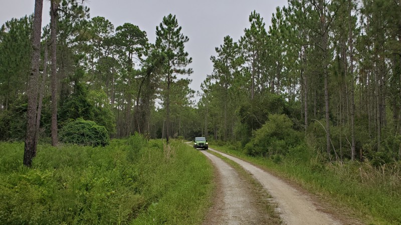
Updated: 04/29/2026
Apex Road
Rainbow Lakes Estates, Florida
Apex Road is a beginner-friendly, 3-mile trail located on the southern side of Goethe State Forest in central Florida. This well-maintained dirt and limestone road offers an easy off-road experience with minimal obstacles, making it perfect for AWD cars, 2WD trucks/SUVs, and drivers of all skill levels. The mostly straight trail features short corners and no significant elevation changes, with only scattered potholes presenting minor challenges. Explorers will enjoy diverse scenery ranging from prescribed burn areas to overgrown brush sections and cleared logging zones. Since the trail is actively used by the Florida Forest Service and logging companies, visitors should expect to encounter heavy equipment during their journey. This accessible route provides an excellent introduction to off-road driving within the expansive 54,000-acre state forest.

Upgrade your Membership
Unlock all of the details on every Trail Guide and Scout Route.
Start a 7-day Free TrialCommunity
Partners