


By clicking "ACCEPT", you agree to be the terms and conditions of each policy linked to above. You also agree to the storing of cookies on your device to facilitate the operation and functionality of our site, enhance and customize your user experience, and to analyze how our site is used.
Oregon Off-Road Trails
52
Total Trail Guides 48

409
Detailed Waypoints 127
Try a Free 7-Day Trial and unlock it all
Start a Free Trial Most Recent Trail Reviews
No Rating
Open
Visited: 06/26/2026
According to MVUM data, this trail should be open for the season.

Trails Offroad
No Rating
Open
Visited: 06/26/2026
According to MVUM data, this trail should be open for the season.
Trails Offroad
No Rating
Open
Visited: 06/26/2026
According to MVUM data, this trail should be open for the season.
Trails Offroad
No Rating
Open
Visited: 06/26/2026
According to MVUM data, this trail should be open for the season.
Trails Offroad
No Rating
Open
Visited: 06/26/2026
According to MVUM data, this trail should be open for the season.
Trails Offroad
No Rating
Open
Visited: 06/26/2026
According to MVUM data, this trail should be open for the season.
Trails Offroad
No Rating
Open
Visited: 06/26/2026
According to MVUM data, this trail should be open for the season.
Trails Offroad
No Rating
Open
Visited: 06/26/2026
According to MVUM data, this trail should be open for the season.
Trails Offroad
No Rating
Open
Visited: 06/26/2026
According to MVUM data, this trail should be open for the season.
Trails Offroad
Rated 5/5
Open
Visited: 05/08/2026
Having visited in May, I can confidently say this is one of the best times to experience the Cow Lakes Recreation Area. The lakes are full, migratory birds fill the marshes, and wildflowers blanket th...

Rose Meirs
Official Crew
Rated 4/5
Open
Visited: 05/07/2026
We tackled Board Corral Trail in our EarthRoamer and found it to be a fun and engaging drive, but one that took considerably longer than we expected. While the trail itself isn't exceptionally difficu...

Wide Open Roams
Official Crew
Rated 5/5
Open
Visited: 05/06/2026
We drove Succor Creek Road as part of our travels through the Owyhee Canyonlands and found it to be one of the easier yet more scenic routes in the region. If you're looking for a relaxing drive that ...
Wide Open Roams
Official Crew
Rated 5/5
Open
Visited: 05/04/2026
Leslie Gulch Road ended up being one of our favorite drives in the Owyhee Canyonlands. The route winds its way down toward Owyhee Lake, passing through some truly unique scenery that feels completely ...
Wide Open Roams
Official Crew
Rated 4/5
Open
Visited: 05/04/2026
We drove Mahogany Gap while exploring the Owyhee region and found it to be a scenic, easy-going route that offers a great introduction to the area. This isn't a trail that challenges your vehicle, but...
Wide Open Roams
Official Crew
Rated 5/5
Open
Visited: 05/03/2026
We took the trail out to Mickey Hot Springs while exploring the East Steens area, and it ended up being one of our favorite stops in southeastern Oregon. The drive itself was straightforward and easy ...
Wide Open Roams
Official Crew
Rated 5/5
Open
Visited: 05/03/2026
We drove the East Steens Road while making our way through southeastern Oregon and ended up really enjoying this route. Before starting the main stretch along the Steens, we stopped at Borax Lake Hot ...
Wide Open Roams
Official Crew

Richard Goins
Rated 4/5
Open
Visited: 01/15/2026
I can see this being an easy trail in good conditions and most of it was pretty tame, but the last big left hand turn near the top is deeply rutted and slick wet clay. Took careful line choice and a l...
A
alhounos
No Rating
Seasonal Closure
Visited: 12/31/2025
According to this trails management agency, the trail is likely closed for the season.
You can reach out to the agency for more details.
Be sure to leave us a report and let us know ...
Trails Offroad
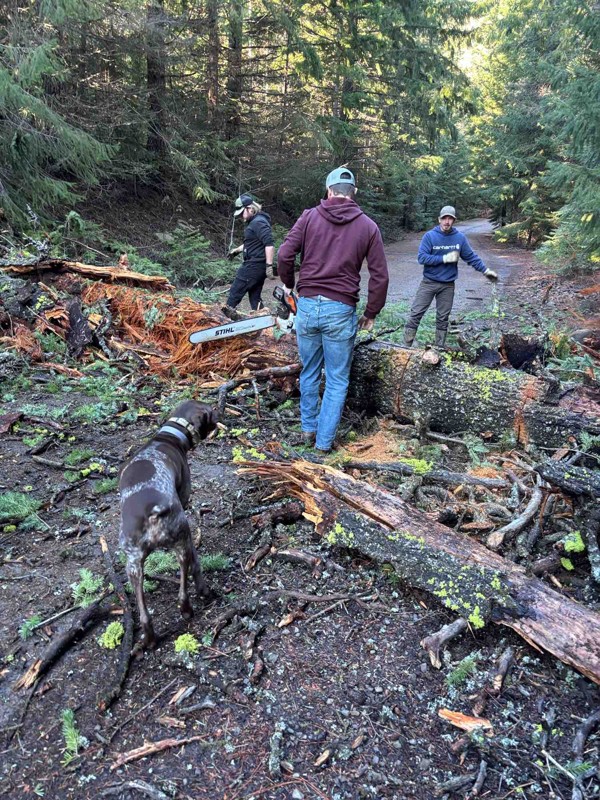
Rated 4/5
Partially Open
Visited: 12/18/2025
Dozens of trees down on the roads!
My guys and I cleared a dozen or so trees and actually had a good time with our chain saws. Just started running out of daylight. I’m
SR
Steven Ritchie
No Rating
Seasonal Closure
Visited: 12/15/2025
According to this trails management agency, the trail is likely closed for the season.
You can reach out to the agency for more details.
Be sure to leave us a report and let us know ...
Trails Offroad
Rated 4/5
Open
Visited: 12/08/2025
Came during a bad storm. It turned a normally relaxing drive into a fun adventure!
Richard Goins
No Rating
Seasonal Closure
Visited: 12/01/2025
According to this trails management agency, the trail is likely closed for the season.
You can reach out to the agency for more details.
Be sure to leave us a report and let us know ...
Trails Offroad
No Rating
Seasonal Closure
Visited: 12/01/2025
According to this trails management agency, the trail is likely closed for the season.
You can reach out to the agency for more details.
Be sure to leave us a report and let us know ...
Trails Offroad
No Rating
Seasonal Closure
Visited: 12/01/2025
According to this trails management agency, the trail is likely closed for the season.
You can reach out to the agency for more details.
Be sure to leave us a report and let us know ...
Trails Offroad
No Rating
Seasonal Closure
Visited: 12/01/2025
According to this trails management agency, the trail is likely closed for the season.
You can reach out to the agency for more details.
Be sure to leave us a report and let us know ...
Trails Offroad
No Rating
Seasonal Closure
Visited: 12/01/2025
According to this trails management agency, the trail is likely closed for the season.
You can reach out to the agency for more details.
Be sure to leave us a report and let us know ...
Trails Offroad
No Rating
Seasonal Closure
Visited: 12/01/2025
According to this trails management agency, the trail is likely closed for the season.
You can reach out to the agency for more details.
Be sure to leave us a report and let us know ...
Trails Offroad
No Rating
Seasonal Closure
Visited: 12/01/2025
According to this trails management agency, the trail is likely closed for the season.
You can reach out to the agency for more details.
Be sure to leave us a report and let us know ...
Trails Offroad
No Rating
Seasonal Closure
Visited: 11/30/2025
According to this trails management agency, the trail is likely closed for the season.
You can reach out to the agency for more details.
Be sure to leave us a report and let us know ...
Trails Offroad
No Rating
Seasonal Closure
Visited: 11/30/2025
According to this trails management agency, the trail is likely closed for the season.
You can reach out to the agency for more details.
Be sure to leave us a report and let us know ...
Trails Offroad
No Rating
Seasonal Closure
Visited: 11/30/2025
According to this trails management agency, the trail is likely closed for the season.
You can reach out to the agency for more details.
Be sure to leave us a report and let us know ...
Trails Offroad
No Rating
Open
Visited: 11/16/2025
I had the most fun after the tree. Waypoint 9 and after specifically.
DF
Drew Flury
No Rating
Open
Visited: 11/12/2025
beautiful trail with some fun technical sections. Definitely pinstripping with a full size and quite a few sections I would not want to be in stock vehicle. Being from Colorado this was my first Orego...
Brian R
Open
Visited: 11/09/2025
Wet clay on switchbacks made this trail pretty engaging. There are some stumps mid trail.
DF
Drew Flury
Open
Visited: 11/09/2025
Not a bad first time out. One vehicle.
DF
Drew Flury
No Rating
Open
Visited: 11/08/2025
Great trail with wonderful views of the surrounding area. Easy gravel road driving for the most part with a few deeper ruts. Creek running across trail was high and I could not see the bottom or measu...
C
Carl
Rated 4/5
Open
Visited: 11/08/2025
The gates at Kingsley were locked so we had to take 3117 to 3111 to 3010 to get to Dead Point Rd. There was some standing water on the trail, but nothing too serious and traction was good overall. The...
JT
Jesse T
Open
Visited: 11/01/2025
Pretty fun despite how short the trail is!
Richard Goins
Rated 5/5
Open
Visited: 10/09/2025
Tight trail, even for a 2 door. Also the difficulty rating for this trail should be increased to a 5. Especially for after waypoint 9 as others have mentioned.
Jason Stockman
Rated 4/5
Open
Visited: 10/06/2025
So much fun. Definitely recommend a rental given the high probability you will want to go in the water. Sure it’s easy, so a different kind of fun than the mountains but worth a visit.
M
Matthew
Open
Visited: 09/28/2025
Just past Waypoint 2, immediately after the Beaverdam Road crossing, there is a *very* sharp and narrow left turn between multiple trees that was just a bit too much for my truck's turning radius. The...
Buck
Rated 3/5
Open
Visited: 09/21/2025
This isn’t a trail but is a gravel super highway. Leave your tires at highway pressures and cruise the Steens in comfort at 40-60 mph depending on conditions and your ability to keep your eyes on the ...
Ryan
Rated 2/5
Open
Visited: 09/19/2025
Fast, easy gravel road through desolate cattle range. A couple of side spurs go to the canyon’s edge. The views are okay but there are better canyon views elsewhere in this region. Three Forks is a wo...
Ryan
No Rating
Open
Visited: 09/18/2025
Just a feeder for other trails. Gently rolling hills of cattle range. Road was very smooth gravel. Quick to travel.
Ryan
No Rating
Open
Visited: 09/18/2025
Just a feeder for other trails. Gently rolling hills of cattle range. Road was very smooth gravel. Quick to travel.
Ryan
Rated 5/5
Open
Visited: 09/18/2025
Highly worth the 5 minute side trip (each way) to see the crater and lava flows if you are going to Birch Ranch. Some of the lava looks like it was just flowing yesterday and then froze in position. I...
Ryan
Rated 5/5
Open
Visited: 09/18/2025
Beautiful setting for an old ranch. Easy to access in dry conditions by any 4wd with some clearance and with low gears for the steep switchbacks and shelf road. The trail forks at the old buildings. T...
Ryan
Open
Visited: 09/14/2025
a bit tight in spots for my 3rd Gen Tacoma
KW
Kristopher Wietrick
Rated 5/5
Open
Visited: 09/07/2025
Trail was nice with tons of Huckleberries along it. Little tight in sections, so expect some pinstriping. Camping at the lake is fun and beautiful. Water is pretty low right now, stay high up on the b...
Travis Neidenfeuhr
Most Popular


Updated: 02/05/2025
Cedar Tree
Open
/
Banks, Oregon/
4.21 miles/
About an hour
Cedar Tree is an aptly named trail deep in the Tillamook State Forest, where the highlight is a huge fallen cedar trunk that vehicles used to be able to drive under. The iconic fallen cedar tree at Waypoint 7 is a favorite place for photographs of 4x4 rigs. The trail wanders through the forest's prettiest and most exciting sections along the cedar tree. A significant, deep depression is often filled with water and makes for an exciting challenge to cross. An ancient tree stump hides a shelf that can catch the unsuspecting driver by surprise. Cedar Tree is one of the highlights of Tillamook State Forest and should be one of your must-do trails while visiting the park.

Updated: 06/13/2024
Barlow Trail
Open
/
Wamic, Oregon/
22.12 miles/
About 3 hours
Barlow Trail begins at the edge of the prairies and oak scrublands of Central Oregon before heading into a dense forest of Ponderosa Pines. The pine trees give way to Douglas Firs, Western Larch, and other alpine species of fir, alders, and even a few aspen trees before reaching Barlow Pass on the crest of the Cascades. Anyone who played Oregon Trail or Oregon Trail 2 (popular educational video games in the late 80s and 90s) in grade school remembers the Barlow Road route to Oregon City and the promised land of the Willamette Valley. When the pioneers came to The Dalles, they either chose the water route down the rapids of the Columbia River long before the dams were built, or they turned south along the eastern flank of the Cascades to head over the mountains on the Barlow Road. Avid players of the Oregon Trail games most certainly remember the perils of going down the rapids where many lives were lost over the period of mass migration along the Oregon Trail. The Barlow Road route was not without its perils, especially early in the fall when snow storms could move in with little warning, covering the pass in a thick blanket of cold, wet snow. Many pioneers found it to be the most difficult 100-mile stretch of trail from Nebraska to Oregon. Construction of the Barlow Road was authorized in December 1845 by the Provisional Legislature of Oregon. Sam Barlow, who had scouted the route with a party of several wagons earlier in 1845, got to work in the spring of 1846 clearing timber and building the first crude track through the dense old-growth forests on the southern flanks of Mount Hood. Sam Barlow and his business partners only operated the toll road for two years before the toll concession passed into a succession of other hands. Today the segment of the Barlow Road between the eastern edge of the forests and Barlow Pass is now known as Barlow Trail (NF-3530) and is open to 4x4ers, overlanders, and those with an adventurous spirit.

Updated: 12/19/2025
Bennett Pass Road
Partially Open
/
Government Camp, Oregon/
10.87 miles/
About 2 hours
Winding along narrow shelf roads, through alpine forests, and past some of the prettiest views in northern Oregon, Bennett Pass Road is a jewel of the Mount Hood National Forest. The amazing views of Mount Hood will be treasured memories for years to come. In the mid-to-late summer, wildflowers bloom along the many hidden hanging meadows and high prairies. Droves of butterflies can swarm around your vehicle on sunny summer afternoons making you think you're in a fairy tale. On very clear days, you can see from Mount Hood and Mount Adams to the north and all the way down south to the Three Sisters and maybe even Diamond Peak. Views to the east span hundreds of miles of high desert and the Oregon Outback.

Updated: 02/05/2025
Firebreak Five
Open
/
Banks, Oregon/
2.3 miles/
About 2 hours
Firebreak Five is a trail that can go from mild to wild depending on conditions. In dry summer weather, most vehicles can navigate the entire trail by taking the easiest lines and combining good spotting and good driving. In the soggy winter months, certain sections of the trail, such as Waypoint 4, can become incredibly difficult or even impassable for all but trucks rolling on sticky tires, with front and rear lockers, or with little regard for possible drive-train damage. The changing conditions and challenges that voyagers along Firebreak Five face are all part of the adventure. Firebreak Five also has the distinction of being a "Jeep Badge of Honor." For those looking for a big challenge, there is an optional rock garden, and there are very difficult lines to take on the obstacles that will challenge even the most built rigs.

Updated: 01/14/2025
Succor Creek Road
Adrian, Oregon
Succor Creek Road is a mixture of rolling desert grasslands, breathtaking canyons, and agricultural land. Located in eastern Oregon and part of the Bureau of Land Management, Succor Creek Road also runs through the Succor Creek State Natural Area. Coming from the Adrian side, the trail starts alongside sheep ranches that were built and settled by Basque migrants between the 1880s and 1930s. The trail then winds through the grasslands, where you will periodically see free-range cattle grazing. You will then come up by Succor Creek, a burbling stream that drifts beside the road and cuts through the canyon. Then you will start noticing the rising cliffs and rock formations that are part of Succor Creek State Natural Area. This area is ground zero for rockhounders searching for thundereggs which are designated as Oregon's state rock. Succor Creek Road gradually winds back to rolling grasslands, ending with agricultural land once again. There are a number of offroad trails off this road that are great for exploring during dry weather. Succor Creek Road and Leslie Gulch Road are two great trails to combine for an easy scenic day trip.

Updated: 01/06/2024
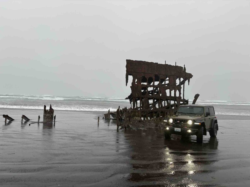
Gearhart to Warrenton
Gearhart, Oregon
This is the longest section of Oregon beach that is open to vehicles. This trail provides exceptional access to the beach and the ocean. This beach route will take you through Del Rey Beach State Recreation Site, Sunset Beach State Recreation Site and Fort Stevens State Park. You can spend the day beachcombing, hiking, fishing, surfing, horseback riding, watching wildlife, exploring a shipwreck and the adjacent historic military fort.

Updated: 06/03/2025
Lolo Pass Road
Mount Hood, Oregon
Lolo Pass is an iconic mountain pass in Oregon that hugs the northwestern shoulder of Mount Hood. Throughout the Lolo Pass trail, breathtaking views of Mount Hood loom large around every corner. During the snowy season and before the trail closes, Lolo Pass offers some of the best up-close scenic views of Mount Hood without the need to drive up US Highway 26 to Government Camp or Timberline Lodge. The views change drastically during the four seasons giving some of the most iconic views of Mount Hood while requiring low effort to reach the viewpoints.

Updated: 09/20/2023
Leslie Gulch Road
Adrian, Oregon
When you drive along the rock formations of Leslie Gulch , you are reminded of Lord of the Ring's Middle Earth. These captivating, stark, colorful geological formations are the highlights of this trail. Comprised of volcanic ash produced by volcanos millions of years ago, these formations provide a refuge for bighorn sheep, elk, mule deer, numerous birds, and a number of wildflowers, including two rare species.
Leslie Gulch Road is part of the Bureau of Land Management and begins at the junction of Succor Creek Road, another trail that is great to combine for an easy scenic day trip. At the beginning, there is rolling grassland as far as the eye can see, and the wildflowers are beautiful to see in late spring/early summer. The trail then drops into the Upper Leslie Gulch Wilderness Study Area and the Slocum Creek Wilderness Study Area where rock formations towers everywhere. There are a number of hiking trails and climbing opportunities that allows you to explore the rocks even closer. Leslie Gulch dead ends at the boat ramp on Owyhee Lake.

Updated: 12/19/2025
Badger Lake Road
Government Camp, Oregon
Badger Lake Road snakes through a thin ribbon of forest flanked on either side by the Badger Creek Wilderness. After coming around the shoulder of Badger Butte, the trail narrows and plunges down a rocky shelf road toward the lake. Big views of the ridgeline where Bennett Pass Road traverses can be seen across the basin. The palisades in the distance are below Flag Point Lookout. Badger Lake, just after a shallow water crossing, is a wonderful spot to spend an afternoon canoeing, fishing, swimming, or hanging out enjoying the mountain air.

Updated: 05/28/2023
Ginsberg Point Trail
Tillamook, Oregon
The Ginsberg Point Trail is one of only a handful of 4x4 trails in the Trask OHV region of western Tillamook State Forest. Designated as an intermediate trail and comprised of several sections - this is the longest 4x4 trail in the Trask OHV. Although not the most technical of trails, the Ginsberg will provide enough variety of hills, mud, rocks and tree stumps to challenge even the more experienced drivers. As a bonus, there are stunning views of the beautiful forest and surrounding valleys along the way.

Updated: 11/27/2023
Fisherman Road
Adrian, Oregon
Fisherman Road presents breathtaking panoramas of the Owyhee Desert and Canyonlands terrain, showcasing a diverse landscape of grasslands, canyons, and the picturesque Owyhee Lake. Situated in Eastern Oregon, it is under the stewardship of the Bureau of Land Management. As you traverse this trail, see free-ranging cattle and pronghorn gracefully navigating the grasslands against a backdrop of volcanic rock formations. Descend into a charming canyon that unveils striking views of unique rock formations, ultimately leading you to the oasis of Lake Owyhee State Park. This remote haven offers fishing, boating, and camping opportunities, providing a serene escape surrounded by natural beauty.

Updated: 06/09/2023
Hoodraiser / Tillamook State Forest
Banks, Oregon
Hoodraiser is a fun romp through the Tillamook State Forest that is perfect for beginner 4x4ers to get a taste of the adventures that await in the Oregon Coast Range. The trail starts near the South Fork of the Wilson River and heads south and west through the forest toward the top of the ridge. The many water bars cut into the trail give Hoodraiser its name. Going up and over the water bars obscures the view of the trail because the hood of the vehicle is pitched up into the air -- hence the name Hoodraiser. Several narrow sections (wide enough for full size vehicles) are a fun challenge for drivers learning the dimensions of their vehicles. A few small mud puddles after rains make for a good place to take videos of overlanders driving through the forest.

Updated: 06/05/2022
Bates Road / Tillamook State Forest
Banks, Oregon
Bates Road packs in amazing views of the Oregon Coast Range, a knife-edge ridge to drive along, fun and challenging trails, and the small but real chance of serious vehicle damage. The ridge narrows down to a knife edge in several points with the road running right at the crest. Those who take their eyes off the road are rewarded with views to the north and east across the patchwork of clearcuts and timber. Deep dug out sections of trail make for moments of slipping, moments of unexpected gripping, and occasional heart-pumping moments of a barely controlled descent down steep slopes. This is not a trail that Trails Offroad suggests as a first time 4x4 driving experience for beginners. This is a trail that Trails Offroad recommends for adventure and challenge.

Updated: 07/15/2023
University Firepower Part 2 / Tillamook State Forest
Banks, Oregon
University Firepower Part 2 may start out as an easy gravel road but it packs in a few surprises along the way. There are tight, twisty sections in dense forest where it is easy to become disoriented. Never fear though because all dirt paths lead to the end of the trail. Halfway through the trail, explorers are presented with a choice: the high road scrambles up the hill while the low road scuttles around the side. Choose your way wisely based on your vehicle's abilities and the trail conditions because the high road can be unforgiving if a mistake is made. The trail ends near where Cedar Tree trail begins which is an excellent place to head next after finishing University Firepower Part 2.


Updated: 06/04/2026
Board Corral Loop
Rockville, Oregon
Board Corral Loop is an enchanting connector trail that can start from Leslie Gulch , or from Fisherman Road in the north. It is a one-track road less traveled but is becoming more popular with UTVs, ATVs, and 4x4s. Due to grades, the road is done in 2WD or 4HI, but some places are more washed out, especially on grades that will need more concentrated tire placement. It is advisable to avoid this trail when it is muddy and tread lightly. There are free-range cattle in this area, so be aware and remember that they have the right of way. You will no doubt see wild horses from time to time. The rock formations are inspiring, and it is fascinating to see the landscape change from sharp outlines of canyons to the rolling high desert plains.

Updated: 06/04/2026
Mickey Alvord Wells
Andrews, Oregon
Mickey Alvord Wells loop will take you by the Mickey Hot Springs, a geothermal springs area that is too hot for soaking but is a colorful boiling geological marvel. The main access to this trail is from East Steens Road. The Mickey Alvord Wells loop continues past the hot springs and into the high desert going by a cowboy camp and circling back toward East Steens. The trail is relatively easy to the springs. Once past it, you will periodically go over rougher rocky patches. You can also access the Alvord Desert Play on the southern side of the loop. There is one visible dispersed campsite across from the Mickey Hot Springs trailhead.

Updated: 12/19/2025
Lookout Mountain Road
Government Camp, Oregon
People come to Lookout Mountain Road for two reasons: alpine prairies full of flowers and big views of Mount Hood. This road delivers on both accounts. The smooth, well-graded gravel road can be traversed by any sedan as long as there is not snow on the road. In summer, the alpine prairies, wet meadows, and forests are full of insects including wild bees and butterflies. At several points along the road, Mount Hood jumps out from behind a corner in all her splendor. While the majority of the road is in big timber, there are lush alpine prairies, wet meadows, and some outstanding views of the eastern flank of Mount Hood along the way. Running the road south-to-north will give you the best views of Mount Hood.

Updated: 10/15/2024
Steens Mountain Loop
Diamond, Oregon
Steens Mountain Loop includes the highest road in Oregon and is one of Oregon's extraordinary scenic and geologic wonders. The trail comprises deep glacier-carved gorges, wild rivers, a rich diversity of plant and animal species, and alpine lakes with aspen for shade. It is also home to a herd of the famous wild Kiger mustangs featured in the movie "Spirit." A few established campgrounds and dispersed camping sites are along the trail and viewpoints to pull over and take in the breathtaking scenery from wilderness canyons to the Alvord Desert in the east and learn about the formation of this spectacular mountain range.

Updated: 06/10/2023
The Jeep Trail
Tillamook, Oregon
The Jeep Trail is one of only a handful of 4x4 trails in the Trask OHV region of western Tillamook State Forest. This is a purely scenic trail, offering the explorer a narrow, but enjoyable route among huge ferns, moss-covered trees, and stunning views.

Updated: 10/15/2024
Silent Creek
Beaver Marsh, Oregon
Silent Creek is an easy scenic drive through the Winema National Forest. It's a point-to-point road that connects Highways 97 and 138. You will encounter some washboarding but nothing technical. Ample dispersed camping is available throughout this roadway and is accessible by two-wheel and four-wheel drive vehicles. If you are interested in the history of this area, information boards along the trail highlight logging industry history dating back into the 1920s.

Updated: 12/01/2023
Hood River OHV Trail 199
Hood River, Oregon
Just outside of Hood River, Oregon Trail 199 is short in distance but easy and fun to drive. It can be used as a connector to several other OHV Trails and Forest Service Roads in the area around Kingsley Reservoir. This narrow trail is within the forest, with thick trees lining both sides. Amazing views of Mt. Hood and the Hood River Valley can be seen from nearby roads. Typically used as a short section of a longer route – this uphill climb has plenty of decent-sized rocks and ruts to challenge the novice driver.

Updated: 06/05/2022
Saddle Up Part One / Tillamook State Forest
Banks, Oregon
Saddle Up Part One is one of the few trails in the Tillamook State Forest with a shelf-style road where there is big exposure if a driving mistake is made. There is nowhere to turn around once committed to the trail and only one or two places where one or at most two vehicles can get off the road to let others pass. Limited sight lines make for an exciting time wondering what or who is around the next bend. An optional obstacle makes for an interesting puzzle to tackle. The views on a clear day from the section of trail around Waypoint 2 make it all worthwhile though. Expansive panoramas to the south provide a stunning setting to take photos of vehicles seemingly perched on the edge of a cliff. On stormy days, near white-out conditions can frequently occur where visibility is no more than 100 feet at times. Even on bad weather days, Saddle Up Part One is still a worthwhile trail for adventurous explorers in the Tillamook State Forest.

Updated: 06/04/2026
East Steens
Princeton, Oregon
East Steens Road is the main access road into the surreal Alvord Desert Playa. East Steen's skirts along the eastern escarpment of Steens Mountain and the vast expanses of the Alvord Desert provide a scenic study in dramatic contrasts. Bighorn sheep and pronghorn antelope can be seen adjacent to the road with binoculars. East Steens is also the access to Mickey Alvord Wells that goes to Mickey Hot Springs. There is no camping along East Steens Road, but spurs and access roads from the road offer great camping sites.

Updated: 04/01/2024
Flag Point Lookout Road
Tygh Valley, Oregon
Sweeping views of Mount Hood, the Badger Creek Wilderness, Central Oregon, and the Cascade range from Mount Adams to The Three Sisters await visitors to Flag Point Lookout Road. The Forest Service fire lookout is staffed during summer months and, if official duties don't take prescience, the lookout staff often invite people up into the lookout tower. A short hike from the lookout to the helipad provides breathtaking views of Badger Creek Basin, The Palisades, and Mount Hood.

Updated: 04/01/2024
Grasshopper Road
Government Camp, Oregon
From dense second growth forest to exposed shelf road to alpine meadow, Grasshopper Road has a little bit of everything. The lower third of the trail is paved and smooth while the upper two thirds become increasingly rocky and narrow. The shelf road affords sweeping vistas of the basin to the south and the White River area where the famed Barlow Trail once brought pioneer wagon trains across the Cascades to the Willamette Valley. At the terminus of Grasshopper Road, expansive alpine meadows tumble down the ridge hiding a small, idyllic Forest Service campground.

Updated: 04/01/2024
Bonney Meadows Road
Government Camp, Oregon
Starting at the notch between the Hood River drainage, the White River drainage, and Boulder Creek Basin, Bonney Meadows Road wanders through the forest and across a fun shelf road on its way down to the paved forest roads in the Barlow Road corridor. Huge meadows full of wildflowers peak through the forest to the east of the road. A fun side trail to an aerial raptor highway is just a mile from a great Forest Service campground. Down at lower elevations, old clear cuts are thick with young trees and dispersed camping.

Updated: 06/16/2023
Knob Loop
Clatskanie, Oregon
Knob Loop is one of five 4x4 trails and part of the Nicolai Mountain ORV Park located in the Clatsop State Forest, just 8 miles west of Clatskanie, Oregon. The trail winds about 2 miles through old-growth forest and can be a challenge with all the tree root systems especially when visiting in the spring or late fall when standing mud and water can really be expected. During this write-up, the author did have to winch out of one obstacle but for the most part, this trail was very fun and challenging in June. Please do not attempt to bypass any part of the trail and be ready for recovery if attempted.

Updated: 01/18/2026
Upper Tunnel Road
Owyhee Heights, Oregon
Upper Tunnel Road splits off from the popular Succor Creek Road, which takes sightseers and campers into the Owyhee range and the incredible Leslie Gulch area. Upper Tunnel is a shortcut from this route to the Owyhee Reservoir and multiple campgrounds and fishing spots. Sharp and uneven rocks dominate the first two-thirds of the route on a seldom-used two-track with steep inclines on loose gravel. Airing down is highly recommended, as these rocks can lead to tire punctures. There are numerous beautiful sights, including a spectacular reservoir overlook and surrounding canyons. This portion of the route is difficult and rough but doable for most 4x4s with clearance.
The last third of the trail becomes severe, with a very steep descent and multiple tight switchbacks on a dangerously loose rock-laden trail. This portion is not for the faint of heart and inexperienced offroaders. Please note that pictured in this review is a trailer. This is not advised on this trail and only increases the difficulty and risk level on this expert-level descent.
The beautiful reservoir includes three campgrounds, top-tier fishing opportunities, and water-based recreation.

Updated: 09/22/2025
Blowout Reservoir Road
Sheaville, Oregon
Blowout Reservoir Road is the main access road to Jordan Craters, Coffeepot Crater, and the historic Birch Creek Ranch. It begins at the junction of Jordan Craters Road and Lodge Ranch Road, and ends at the junction of Morcum Road and Crater Lake Road. The landscape first begins as a high rolling desert, with free-ranging cattle, and then finally, to the left, the lava fields of Jordan Craters become visible as the road winds along the edge of the lava. The road is mainly flat with occasionally wet weather creek crossings. It is best suited for four-wheel-drive vehicles or vigilant AWD drivers with clearance. This road can easily become impassable after even a quarter-inch of rain.

Updated: 10/15/2024
Beaverdam Road
Glenwood, Oregon
Beaverdam Road is a forest service road located in the Tillamook State Forest. This is a major access road with access to many 4x4 Jeep trails including: "University Firepower", "Cedar Tree" and "Firebreak Five". There is a detour where you turn off onto "University Falls Road" for about a half mile due to bridge work. There are many side roads with dispersed camping spots and really awesome views of the surrounding hills. There is a campground called "Browns Camp ORV Campground." This is also a staging area for parking tow rigs and trailers. This campground is designated only for OHV camping.

Updated: 06/05/2022
Firebreak One / Tillamook State Forest
Banks, Oregon
Firebreak One is a great introduction to the Tillamook State Forest and the Brown's Camp Area. As soon as the trail plunges into the moss-covered, dripping wet forest of the Oregon Coast Range, the adventure begins. The trail winds through second growth timber on the way to the top of the ridge where it suddenly bursts through the trees into a vast clear-cut with sweeping views to the west. The trail turns into a gravel road on top of the ridge and continues through a mix of second and third growth forest, and clear-cuts on its way down to one of the main roads through the forest.

Updated: 06/05/2022
Can Opener #28B / Tillamook State Forest
Tillamook, Oregon
The challenging obstacle at the end of Can Opener gives the trail its name and makes this a fun trail for rock crawlers. After crossing a gatekeeper boulder field, the trail heads up a steep hill to a boulder pile at the top of the hill. Many big, built rigs spend hours playing around on the boulders and trying the more challenging lines through the obstacle. The shaded forest setting and ample parking make this a great spot to spend a little time watching 4x4s crawl through the forest.

Updated: 12/19/2025
Cold Springs Road
Government Camp, Oregon
The alpine meadow section of Cold Springs Road runs through lush meadows full of wildflowers and butterflies. Small wet springs in the forest produce vibrant bursts of wildflowers under the shade of the forest canopy. The ample dispersed camping along Cold Springs Road never fills up even on the busiest of weekends. At the beginning of Cold Springs Road, peaks of Mount Hood looming large round out this trail to be a very scenic drive.

Updated: 09/27/2025
North Paulina Road
Deschutes River Woods, Oregon
This is a point-to-point route connecting Highway 97 and Paulina Lake Road. Driving is much more challenging than most of the surrounding roads and trails.
It starts like most of the forest service roads in the area. After about 10 miles, though, it starts to climb and traverse several buttes and mountains. You will experience narrow and off-camber sections, 12" ledges, lots of rocky and rutted tracks, and a lot of great wheeling that will give a beginning wheeler a good experience. Experienced drivers will find the route easier.
Several areas along the route allow dispersed camping. The road it connects to, FS21, also leads to numerous improved camping areas by Paulina and East Lake.

Updated: 04/01/2024
Clark Mill Road and Tygh Valley Road
Tygh Valley, Oregon
The combined trail of Clark Mill Road and Tygh Creek Road begins at the old two room schoolhouse in the community of Friend, Oregon in the middle of rolling fields of wheat and hay. Mount Hood looms on the horizon to the west where the mountain's snow-pack helps to provide water to the entire region. The trail passes through oak savanna and grasslands with big views to the south of Central Oregon before plunging into the beginning of the canyon that hides Jordan Creek. A hidden waterfall waits to be discovered at Waypoint 5 where an old mill once stood before the trail continues down along the rim of the canyon. Near where Jordan Creek and Tygh Creek meet, the trail plunges into the canyon where fallow farm fields are tucked away between gnarled old cottonwood trees. A shallow stream crossing just before the end of the trail at Waypoint 6 helps to wash the dirt off of tires before the Clark Mill Road and Tygh Creek Road trail comes to an end at the blacktop outside of Tygh Valley, Oregon.

Updated: 10/15/2024
Coldsprings Road / FS-3651
Rocky Point, Oregon
Coldsprings Road is a 10-mile drive through a mature pine forest ending at the Coldsprings hiking trail. Coldsprings Road connects to FS-3652-980, which takes you up to the top of Pelican Peak and a Fire-watch observation tower. The road is in excellent condition and will probably be an awesome snow-wheeling road. Multiple camping spots along this road with views of the surrounding hills make this a great road to explore.

Updated: 06/05/2022
7 Up (Easy Way) / Tillamook State Forest
Banks, Oregon
The 7 Up (Easy Way) trail is a challenging but manageable adventure through the forest to the top of the hill where the iconic 7 Up (Hard Way) trail connects. There are three legs to 7 Up which include two legs that are passable by normal 4x4s (detailed in this trail description) and one leg that is a challenge for even the most built buggies (detailed as the 7 Up (Hard Way) trail). On warm summer afternoons, rock buggies can often be found battling up the 7 Up (Hard Way) trail where they often break axles, drive lines, and occasionally flip over and crash down the hill. The 7 Up (Easy Way) trail is a popular trail that many overlanders enjoy throughout the year. The trail winds up and down through a deep, dark forest where night time comes hours ahead of schedule. Thick moss hangs from the trees in some areas and lends a magical, enchanted aura to the trail especially in the late afternoon and early evening.

Updated: 10/15/2024
Shingle Mill Road
Bradwood, Oregon
Shingle Mill Road provides access to the Nicolai OHV area. It is a well-graded gravel road that rises in elevation to about 2200 feet. There are many beautiful views of the surrounding valleys and a few waterfalls along this road.

Updated: 06/05/2022
Antelope Springs Road
Adrian, Oregon
Antelope Springs Road is a wonderful trail that winds thru the Owyhee grasslands and overlooks the steep gorges of the Succor Creek State Natural Area. Located in eastern Oregon, this trail is just over the border of Idaho and a part of the Bureau of Land Management. Coming from Succor Creek, the trail begins at the Succor Creek Campground. It includes a couple of wet weather creek crossings. This is a favorite area for rockhounds to find thundereggs and fossils. This is also part of a popular route that combines Jump Creek Falls in Marsing, Idaho, and the Succor Creek State Natural Area. The best time to visit is late spring, early summer, and fall.

Updated: 09/17/2023
Hogs Back / Tillamook State Forest
Banks, Oregon
Hog's Back is a fun trail that follows the spine of a ridge and hides a few surprises. On the top of the ridge, a rock garden has been installed for anyone wishing to test their skills. The descent into the dense forest on the north end of the trail becomes tricky as the trees close in on the road. Full size vehicles are not recommended but most SUVs and light pickups can make it through by executing three point turns as needed. A big view to the north peeks through the trees as the road hugs the edge of a cliff overlooking a quarry. Hog's Back has a little of everything and is a worthwhile trail to explore in the Tillamook State Forest.

Updated: 06/05/2022
Stick in the Nose #37 / Tillamook State Forest
Tillamook, Oregon
Stick in the Nose is an apt name for this tight trail where brush encroaches on both sides of the dirt track and tree branches hang low. Gatekeeper obstacles and a challenging rocky obstacle halfway along the trail make for a challenging but achievable adventure through third growth forest on the way up to the top of Fox Creek Ridge. On clear days, Archer's Ridge across the Jordan Creek drainage can be seen to the north. On rainy, cloudy days, driving on Stick in the Nose feels like going to another planet where it is highly unlikely any other vehicles or people will be encountered.

Updated: 03/11/2025
South Fork Road
Jordan Creek, Oregon
South Fork Road is located in the Tillamook State Forest. The road intersects with US Highway 6 and climbs up into the western end of the forest. This major access road connects to many 4x4 Jeep trails, including Hoodraiser, Archers Firebreak #28, Can Opener #28B, 7 Up, and Waldo's Way. When explored, there are many side roads where you will find dispersed camping spots and some really awesome views of the surrounding hills.

Updated: 06/05/2022
Archers Firebreak #28H / Tillamook State Forest
Tillamook, Oregon
Archers Firebreak #28H starts out and ends mild but in between the trail can get pretty wild. The trail is a continuation of the Archers Firebreak series of trails that march west along Archers Ridge. On days with decent weather, a huge view of the Oregon Coast Range await along the trail. Adding to the excitement, a challenging dug-out section of trail with a deeply cut center rut that is eager suck unwary vehicles into its hold. Along the way, the trail passes through second growth forest and recent clearcuts offering up scenic views of the Jordan Creek drainage and great memories.

Updated: 10/15/2024
Morcum Road
Danner, Oregon
Morcum Road is a gorgeous scenic drive descending from rolling high desert outback to a challenging grade headed to the Owyhee River with 180-degree breathtaking views of buttes, cliffs, mountains, and rock formations. As you reach the Owyhee River, you can find petroglyphs, an old homestead called Hole in the Ground, and the old Owyhee rock dam remnants. 4WD with high clearance is highly recommended for this trail due to the steepness of the grade and rocky terrain. Do not attempt the trail when it is wet. There are some flat spots by the river for dispersed camping, but be sure to abide by the signs showing Wilderness Study Areas where motorized vehicles are prohibited. You can access Morcum Road from Blowout Reservoir Road and Crater Lake Road.

Updated: 09/22/2025
Jordan Craters Road
Sheaville, Oregon
Jordan Craters Road is the main access road to Jordan Craters, an extinct volcanic field, and the historic Birch Creek Ranch. This road is flat gravel that travels through a high plain desert landscape comprised of sagebrush, ranging cattle and ranch buildings in the distance. Jordan Craters Road begins at the intersection of ION-95 and ends at the junction of Blowout Reservoir Road and Lodge Ranch Road. There are no dispersed campsites along this road. Several jeep trails connect to this road, but it is overall an out and back connector for the primary traffic. Please be mindful of the free-ranging cattle, and remember that they have the right of way.

Updated: 10/29/2024
Powerline #4D / Tillamook State Forest
Banks, Oregon
Powerline #4D combines some interesting, tight segments of trail through the forest with a stretch of gravel access road as it follows the high tension power lines toward the coast. A fun and challenging optional section is available for those who want to attempt a reasonably difficult stretch of trail with few significant risks. There are good views near Waypoint 4 looking back to the east along the power lines.

Updated: 02/07/2026
Iron Mountain
Owyhee Heights, Oregon
The highlight of this trail is Iron Mountain which resembles blocks of Legos or Lincoln Logs that have fallen and have tumbled from the peak. This is an in and out one track trail that begins at Board Corral Loop. Due to grades, the road is done in 4HI, and some places are more washed out that will need more concentrated tire placement. It is advisable to avoid this trail when it is muddy and tread lightly. Two fence gates will require opening and closing if they are standing. You will likely see wild horses from time to time. There are no visible campsites on this trail.

Updated: 09/22/2025
Birch Creek
Danner, Oregon
The historic Birch Creek Ranch is a fantastic reflection of the hard work of early 1900s pioneers to make a living in very remote but gorgeous Owyhee Canyonlands. Birch Creek Road begins at Blowout Reservoir Road and ends along the Owyhee River with overhanging cliffs and high desert meadows. The ingenuity and determination of a Basque sheepherder and a west Virginia cattle rancher are still evident at the site today. Stone walls built in the Basque tradition still ascend the mesa. Remnants of a waterwheel hint at the lush alfalfa fields fed through the gravity irrigation system. Nineteen buildings and structures at the ranch contribute to the property's designation as a historical rural landscape on the Department of the Interior's National Register of Historic Places. This road is best accessible by a high clearance vehicle or, better yet, a 4-wheel drive. Don't attempt this trail when the road is wet or snow-covered.

Updated: 02/06/2026
Simonsen Road
Birkenfeld, Oregon
Simonsen Road is a well-maintained gravel road providing access to the Nicolai OHV recreation area from the south. The road starts near Fishhawk Lake and rises to 1500 feet in elevation, following a series of ridgelines with amazing views of the surrounding hills and valleys. While there is no camping along Simonsen Road, the many smaller dirt spurs might provide even more scenic views and some hidden campsites. Feel free to explore.

Updated: 12/23/2023
Powerline #4B / Tillamook State Forest
Banks, Oregon
The Powerline #4B trail immediately plunges into a dense second growth forest thick with maples and fir trees dripping with moss and ferns. Depending on how recently the last rains passed through the Tillamook State Forest, visitors may be quite literally greeted with dripping moss and branches hanging low over the trail. A tight switchback points the trail southward toward the high tension power lines. After emerging from the dark and wet forest, the trail turns into a gravel access road that follows under the power lines on their march westward to bring electricity to the communities of the northern Oregon Coast. At the top of the ridge, 4x4ers are greeted with big views to the west across the patchwork of second and third growth timber, and clear cuts. Nine days out of ten, the distant ridges and mountains are veiled in clouds, rain, and mist, but on rare sunny blue sky days, the entire Devil's Lake Branch of the Wilson River Basin is on full display.

Updated: 10/15/2024
University Falls Road
Glenwood, Oregon
University Falls Road is a forest service road located in the Tillamook State Forest. This road does a lower-level loop through the forest and reconnects with US Highway 6. This forest service road is a major access road with access to many 4x4 Jeep trails including: "Powerline #4B", "Powerline #4C" and "Powerline #4D". There are many side roads with dispersed camping and really awesome views of the surrounding hills. Browns Camp ORV Campground is located on Scroggins Creed Road. This is also a staging area for parking tow rigs and trailers. This campground is designated only for OHV camping.

Updated: 04/01/2024
Bonney Butte Road
Government Camp, Oregon
At the top of Bonney Butte Road in good weather on a clear day, Mount Hood looms large to the northwest while the snow-capped peaks of Mount Jefferson and the Three Sisters glisten in the distance to the south. Even though Bonney Butte Road is less than a mile long, it packs in some amazing views and a fun trail with good restroom facilities. The remnants of the old fire lookout, removed in the 1960s, and the interpretive information signs about the annual raptor migration are interesting in their own rights but people keep coming back to Bonney Butte for the views.
The road up Bonney Butte is closed to motorized traffic August 15 - November 1 to protect migrating raptors. However, if you are in the area, the half mile hike from the trailhead parking area to the summit is worthwhile to watch HawkWatch International capture and tag raptors. More information about the migration can be found here: https://hawkwatch.org/migration/item/81-bonney-butte-hawkwatch

Updated: 10/15/2024
Foster Mainline
Taylorville, Oregon
Foster Mainline road is a well-maintained gravel road that is part of a network of dirt roads created for the logging industry. This road provides easy access to the Nicolai OHV recreation area. The road dips in and out of lush valleys. Highpoints along the trail reveal amazing views. While there is no camping along this road, the many side trails provide hours of exploration and access to nice dispersed campsites.

Updated: 10/15/2024
Miller Lane
Arock, Oregon
Miller Lane, the access road to the overlooks for Chalk Basin, offers a breathtaking view of chalk-looking cliffs across the Owyhee River and Iron Point, the deepest part of the Owyhee Canyonlands. Miller can begin at Biscuit Butte Road and Crater Lake Road or at Mud Lake Reservoir Road in the south. The landscape is relatively flat, with free-ranging cattle and winds along the top of the canyon bordering the Owyhee River. This trail is mostly rough and rocky dirt and should not be driven after even a quarter-inch of rain. Do not attempt this trail if wet. There is a dispersed campsite at the overlook spur at Iron Point.

Updated: 06/05/2022
Saddle Up Part Two / Tillamook State Forest
Banks, Oregon
Saddle Up Part Two starts with a big gatekeeper boulder field guarding the entrance to a lovely little stretch of dirt track that switchbacks down through a stand of young fir trees. A second boulder field guards the exit to the first segment of Saddle Up Part Two before the trail allows vehicles to continue onto the final segment that wraps around a small knoll popular with hunters for camping. The trail emerges onto a gravel road at the perfect spot to continue on to explore the Dog Leg trail.

Updated: 10/15/2024
C-Line Road
Glenwood, Oregon
C-Line Road starts at Beaver Dam Road and Saddle Mountain Road intersection. This 8.9-mile road goes over to the west side of the forest and connects with South Fork Road, giving you access to some of the more difficult trails in the area. There are many pull-outs with beautiful views and numerous camping spots from which to choose.

Updated: 01/21/2023
Powerline #4C / Tillamook State Forest
Banks, Oregon
Powerline #4C is a fun jaunt through thickets of alder, maple, and other deciduous trees on the way down to the bottom of the Elliot Creek Drainage. The trail almost immediately narrows to a tight single lane of travel where full-size vehicles might not have the most fun navigating through narrow spots. Depending on when the last maintenance was done on the trail, 4x4s may end up with some pinstriping from brush and trees but that is all part of the charm of Powerline #4C. During the fall, the leaves on the trees turn vivid shades of yellow, orange, and red, making for some very pretty trail segments that are excellent for taking glamour shots of overlanding rigs.

Updated: 06/05/2022
Lyda Hill #100 / Tillamook State Forest
Tillamook, Oregon
Lyda Hill trail is a short but exciting trail that gets progressively more challenging with a deeply rutted section waiting to challenge the nerves of 4x4ers willing to risk potential body damage from laying a vehicle on its side. The trail climbs up the steep, wooded flank of Lyda Hill but never quite reaches the summit before turning back around on itself and pointing adventurers back down the hill.

Updated: 04/01/2024
2730-230 and 2730 Roads
Tygh Valley, Oregon
One can be forgiven for feeling as if an exciting adventure is close at hand while charging down the 2730-230 Road. A rough dirt track snakes through mixed stands of second growth, old growth, and clearcut timber. In the dry summer months, clouds of billowing dust give the distinct impression that this road leads to somewhere important and special. Alas, the end of 2730-230 comes in the form of the smooth blacktop ribbon of 2730. The 2730 Road continues through big stands of timber as it curls around the ridge below Flag Point Lookout on the way to the small village of Friend.

Updated: 06/05/2022
Archers Firebreak #28 / Tillamook State Forest
Tillamook, Oregon
Archers Firebreak #28 is a fun and easy trail that curls down through a recent clear cut from the top of the ridge down to the saddle between Lyda Hill and Archers Ridge. A couple switchbacks on the first part of the trail are a great place to take video of an overlanding rig going on an adventure. This is a popular trail to connect between the trail network in the Browns Camp area (eastern third) of the Tillamook State Forest and the trails that are accessible from the Jordan Creek campground.

Updated: 10/15/2024
Whitehorse Ranch
Basque, Oregon
Whitehorse Ranch Road is a well-maintained 50-mile gravel road that is easy to access. It starts from U.S. Route 95 and extends to Oregon Route 205, 8 miles south of Fields. It is named for the historic cattle ranch Whitehorse Ranch, founded in 1869 by John S. Devine, a well-known 19th-century cattle baron. There are no noticeable campsites off this road, but this road also provides access to the iconic Willow Creek Hot Springs off Whitehorse Fifteen Mile, which offers excellent dispersed camping choices.

Updated: 06/05/2022
Smock Road
Wamic, Oregon
Smock Road is a scenic way to access the Barlow Trail further to the west. The road winds through farm and ranch country, through a creek bottom choked with scrub oak, and across a prairie. When you reach the end of Smock Road, continue on along the Barlow Trail to retrace the wagon ruts of the pioneers on the way to the Willamette Valley during the days of the Oregon Trail.

Updated: 08/11/2025
Paulina Lake Road
Millican, Oregon
This is a point-to-point route starting at FR18, going up and over "The Dome," and ending at East Lake Campground. Along the way, you drive on the rim of a volcanic dome and go through the Newberry Wildlife Refuge. The views and scenery are amazing, and this is a great drive whether you have a destination in mind or not! There are also some pretty epic primitive camping options in addition to all of the camping areas around East and Paulina Lakes.
There are rocky areas with steep inclines. High clearance and all or 4WD may be necessary, depending on your vehicle.

Updated: 10/15/2024
Crater Lake Road
Danner, Oregon
Crater Lake Road can begin in the north at Blowout Reservoir Road and Morcum Road, or at Biscuit Butte Road from the south. The landscape is a gently rolling high desert from the north with free-ranging cattle. It then winds along the lava field. The trail is best suited for four-wheel-drive vehicles with clearance. This trail is not good enough to be traveling after even a quarter-inch of rain: Do not attempt if this is the case. There are no visible dispersed or established campsites along this trail, but camping can be done on the flat surfaces of the lava field.

Updated: 08/11/2025
FR2308
Beaver Marsh, Oregon
Traveling from north to south, 2308 starts off Highway 70. Look for the "Desert Forest Journey" sign. Most of the route meanders along the eastern boundary of Crater Lake National Park. In several areas, fallen trees block the path, and fallen trees are prevalent in this region. A few areas of the trail are narrow, slightly off-camber, and washed out, warranting the moderate rating. Numerous opportunities for dispersed camping abound. The improved Scott Creek Campground, located on FR2010, is also available.

Updated: 06/05/2022
Archers Firebreak #28G / Tillamook State Forest
Tillamook, Oregon
Archers Firebreak #28G is a fun continuation of the Archers Firebreak series of trails in the Tillamook State Forest. The trail romps along the top of Archers Ridge through stands of second growth timber. If it has been raining recently, the big puddles between Waypoints 2 and 3 should be full of water and a fun place to splash through.

Updated: 06/05/2022
Springer Ridge Road
Tygh Valley, Oregon
The story of Springer Mountain Road is one of transition and transformation, of rain and sun, and of the many varied ecosystems of the eastern slope of the Oregon Cascades. The metamorphosis from alpine forest to scrub oak and savanna that started on the 2730-190 road continues in earnest on Springer Mountain Road culminating in wide open oak savanna at the end of the trail. The first tendrils of deep powdery dust reminiscent of the famed Australian Outback bulldust begin on the lower reaches of Springer Mountain Road and continue onto the connecting Shell Rock Road. Rumors of a hidden waterfall lurking on private land and a rock climbing paradise in the Mount Hood National Recreation Area Fifteenmile Unit bring many adventurers to Springer Mountain Road; the adventure of heading east from the crest of the Cascades to the deserts of Central Oregon lures in many off-road enthusiasts to explore this trail.

Updated: 06/05/2022
Ample and Alluring #26 / Tillamook State Forest
Tillamook, Oregon
Ample and Alluring lives up to its name with an ample forest loaded with big ferns, dripping moss, and a tight trail. The trail is alluring to those who like to thread their way through tight spots and challenge themselves with potential exposure to rolling off the trail if a vehicle wanders too close to the edge. After a great romp through the forest and up the mountain, Ample and Alluring pops out of the woods and onto a gravel road that leads to more adventures in the Tillamook State Forest.

Updated: 10/15/2024
Ladd Canyon
Little Alps, Oregon
Ladd Canyon Road, also known as National Forest Development Road 43, is a scenic route in Oregon that winds through the stunning Wallowa Whitman National Forest. This picturesque road takes travelers through dense forests, offering breathtaking views of towering trees and rolling hills. Crossing the summit of Anthony Butte, the road provides stunning vistas of the Pilcher Creek Reservoir and the Wallowa Mountains to the east.
Nature enthusiasts will find this route a haven, with access to hiking, camping, and wildlife observation. The road is rough and not recommended for passenger vehicles or trailers. Along the way, there are opportunities for dispersed camping and the designated campground at Grande Ronde Lake, which has a nightly fee.

Updated: 06/05/2022
Truck Dent
Tillamook, Oregon
Truck Dent is a very short, but scenic trail along the top of a ridge, with just enough challenges to keep the driver on his/her "toes". On a clear day, you will be treated to beautiful 360-degree panoramic views. As a great connector trail combined with other roads in the area - Truck Dent can be experienced from either direction, but going uphill from west to east can make the trail a bit more challenging. The beautiful forest scenery and panoramic views are what makes this trail so fun.

Updated: 08/07/2025
Sun Mountain Road
Fort Klamath, Oregon
Sun Mountain Road connects at the south end where the Jackson F. Kimbell State Recreation Area sits. This area has great campsites with direct access to the headwaters of Sun Creek. This campground is a great way to start or end your day's journey! Sun Mountain Road quickly climbs up the mountainside from the campground and levels off after Sun Pass. From there, it is basically a straight shot to the road's terminus, where it meets with The Dalles-California Highway. You need to be careful on the majority of this road. While it is straight and seemingly well-maintained, there are numerous dips and trees that can catch you off guard if you don't slow down. There are endless opportunities for dispersed camping in the area. Just be ready for mosquitoes!

Updated: 06/05/2022
Old Tractor Road
Wamic, Oregon
Old Tractor Road connects from NF-48 (Barlow Road) down to the Barlow Trail where pioneer wagons once plodded along on their way west toward the promise land of the Willamette Valley during the Oregon Trail days. A mixed scrub oak and pine forest gives way to the open prairies of Central Oregon just after adventurous travelers pass an old abandoned tractor that gives this trail its name. While there are other more extreme trails in the immediate area to connect to the Barlow Trail, Old Tractor Road is a mellow, scenic, and fun way to follow in the footsteps of the wagon trains of the 1840s through 1880s.

Updated: 06/05/2022
Bug Road
Tygh Valley, Oregon
Bug Road is a tale of two seasons: the wet and the dry. During the dry season, the road is a fun, easy path to get from the main road (NF-48 also known as Barlow Road) to Barlow Trail (NF-3530) where pioneer wagons once rolled and where overlanders now drive their trucks to recreate the pioneer days. During the wet season, Bug Road becomes a muddy morass of deep water-filled holes and mud pits that can swallow up a stock vehicle. Only the adventurous with built rigs, relocated air intakes, sealed electrical systems, and a pioneer's spirit attempt Bug Road when the holes are full of water.
Those who explore Bug Road will find the trail winding its way through mixed pine and scrub oak forest, and patchy grasslands away from the busy pavement of NF-48 nearby. Hunters often come to this area to hunt for deer and elk while birders use Bug Road to access the White River Wildlife Refuge to hunt rare birds with their cameras. In the spring, the sweet young grass toward the end of the trail blows in great swirls the afternoon breeze. In the fall, the oak leaves turn brilliant shades of red and orange before the onslaught of winter snows. While the road is short, it is fun regardless of the season and well worth the time to visit.

Updated: 09/22/2025
Coffeepot Crater Road
Danner, Oregon
Coffeepot Crater Road can be accessed from Blowout Reservoir Road and will take you directly to Coffee Pot Crater. This crater is the only feature in Jordan Craters that has vehicle access. The crater is steep-sided and well-preserved. The road into the crater is best suited for four-wheel-drive vehicles or vigilant AWD drivers with clearance and wherewithal. This road is not good enough to be traveling after even a quarter-inch of rain: Do not leave the road if this is the case. Camping is allowed at the parking area with limited days posted on signage. Please be mindful that the temperature in the lava fields can be over 120 degrees in the summer. Lava rocks can be sharp, so be mindful of possible falls while hiking.

Updated: 06/05/2022
Shell Rock Road
Tygh Valley, Oregon
The oak savanna on the eastern ramparts of the Oregon Cascades at the edge of the Central Oregon desert marks the final transition from the wet, fertile valleys and lush, dense forests of the western third of the state into the arid interior; Shell Rock Road bisects the oak savanna on its way to the desert further to the east. The often parched condition of the land along Shell Rock Road creates the right environment for thick, powdery dust reminiscent of the famed Australian "bulldust" to form along long swaths of the road where billowing clouds of dust are the norm during the long dry summer. During the spring when the ground is moist and the grass is green, the thick dust can turn to thick mud. In the winter, the area can be blanketed with snow making Shell Rock Road difficult to find and potentially impossible to pass. The dynamic and changing landscape along Shell Rock Road is a wonderful place to experience a small slice of Central Oregon.

Updated: 07/30/2025
Horsfall Beach
North Bend, Oregon
Horsfall Beach is a go-to spot for offroad enthusiasts craving a relaxed coastal adventure with a side of adrenaline. Tucked within the Oregon Dunes National Recreation Area, this sprawling sand spit between Coos Bay and the Pacific Ocean offers stunning views, silky-soft sand, and endless opportunities for outdoor fun. It’s a hotspot for OHV (Off-Highway Vehicle) riders, thanks to its designated trails and wide-open dune riding areas. Just be sure to air down before hitting the soft sand.
Access the action from the south at Horsfall Beach Campground and OHV Staging Area, or from the north via Spinreel Campground and OHV Staging Area. While beach camping isn’t allowed, you’ll find plenty of options nearby—from ocean-view campsites nestled in the dunes to public and private OHV campgrounds with direct dune access. Whether you're carving tracks across the beach or simply soaking in the coastal beauty, Horsfall Beach promises a memorable ride.

Updated: 10/15/2024
Burnt Ranch
Twickenham, Oregon
Burnt Ranch Road in Mitchell, Oregon, meanders through a picturesque landscape, offering a gateway to some of the region's most stunning natural attractions. Nestled near the vibrant hues of the Painted Hills, this road goes by Byrd's Point, where panoramic views captivate travelers, and the winding John Day River, a serene and scenic waterway. The road is in good condition and maintained to ensure a smooth journey for visitors. While the area's beauty might entice adventurers to camp along the roadside, it is essential to note that camping is only permitted within designated areas. These include the Burnt Ranch Recreation Site and the Lower Burnt Ranch Campground, both situated by the John Day River, providing well-equipped spots to enjoy the tranquility of the surroundings.

Updated: 06/05/2022
Archers Firebreak #28D / Tillamook State Forest
Tillamook, Oregon
Archers Firebreak #28D is a little romp through the forest on top of Archers Ridge. The trail has sections of smooth gravel, sections of dirt track, and a section of muddy trail sunken four feet below the forest floor. This trail is a small part of the larger Archers Firebreak collection of trails that can make for a fun afternoon of exploring in the Tillamook State Forest.

Updated: 06/05/2022
#28D Connector / Tillamook State Forest
Tillamook, Oregon
This trail, part of the Archers Firebreak series of trails in the Tillamook State Forest, is not the monster trail it once was. Trail maintenance several years ago returned the trail to something that can be enjoyed by almost any 4x4er exploring the forest. Spectacular views through the trees into the Jordan Creek area are especially rewarding near sunset when the valley below fills with mist and fog and the sky burns pink and yellow to the west.

Updated: 03/11/2025
Tub Springs Road
Rome, Oregon
Tub Springs Road is a rocky dirt road that offers amazing views of Lower Owyhee River Canyon. The spur towards the trail's southern end is the best part; it's a rocky road that'll take you to an epic view of a horseshoe-shaped bend in the Owyhee River.
This is mostly easy to navigate, but there are occasional steep rocky hills to climb, so 4WD is nice to have but not necessary. However, high clearance is a must for this trek.
Tub Springs Road intersects Kiger Road in the south, which will take you to the Pillars of Rome, a cool rock formation worth checking out. It intersects Rinehart Ranch Road in the north.

Updated: 06/05/2022
Archers Firebreak #28I / Tillamook State Forest
Tillamook, Oregon
Archers Firebreak #28I cuts across the top of Archers Ridge on its way west in the series of Archers Firebreak trails. The trail goes through several areas that were recently logged and include some good views of the Jordan Creek Basin. The trail also cuts through healthy second growth forests before ending in a logging landing at the start of the next trail. Stock 4x4s will enjoy this relatively mild trail.

Updated: 10/15/2024
Hess Road
Homestead, Oregon
Hess is one of those trails that makes you gasp at its steepness, but the climb rewards you with jaw-dropping views of the Snake River and Hells Canyon. As you ascend from the arid lower reaches, the landscape transforms dramatically. Sparse grasses and sagebrush give way to dense forests of Ponderosa pines, and as you climb higher, Douglas firs begin to appear. The Wallowa Mountains, cradling the canyon, present a picturesque ensemble of high peaks, alpine meadows, and valleys sculpted by ancient glaciers. This area is teeming with biodiversity; spotting bighorn sheep, deer, eagles, and other wildlife is common.
While no discernible campsites are directly off this road, spurs lead to primitive camping spots. This single-lane trail is unmaintained, and a high-clearance vehicle is advised to navigate the washouts and gullies. Hess can be accessed from the north at Wallowa Mountain Loop or the south at Homestead Road.

Updated: 10/15/2024
Cow Creek Ridge Road
Vesper, Oregon
Cow Creek Ridge Road is a well-maintained road providing access to the Nicolai OHV area from the south. The road rises quickly to 1200 feet and runs along a ridgeline connecting to Simonsen Road. There is a lot of logging activity in the area, so be aware of the big logging trucks along these narrow roads. There are many side trails leading to beautiful lookouts that would make for fantastic campsites.

Updated: 10/15/2024
Cedar Road
Jordan Creek, Oregon
Cedar Road climbs through a nice forest. Starting at C-Line Road, it dead-ends at a gate after 3.3 miles. There are majestic views of the hills and valleys looking to the south. 4x4 Jeep trails that are accessible via Cedar Road include "7 Up", "Waldo's Way" and "Dog Leg". A few side roads offer limited camping.

Updated: 04/15/2026
McPhillips Beach
Tierra Del Mar, Oregon
Nestled within the Cape Kiwanda State Natural Area, McPhillips Beach is a picturesque two-mile stretch of sandy coastline that remains one of Oregon Coast's best-kept secrets. Just three miles north of the vibrant Cape Kiwanda and Pacific City, this serene beach offers dramatic scenery defined by colorful sandstone formations, towering cliffs, and steep bluffs. Its peaceful setting makes it a delightful alternative to its busier southern counterparts, though it does attract more visitors during peak seasons.
McPhillips Beach provides the perfect backdrop for your coastal adventures. It’s also uniquely vehicle-accessible, allowing you to drive right onto the beach for a closer view of the rolling Pacific waves—just be cautious of the soft sand to avoid getting stuck!
Accessing McPhillips Beach is straightforward, though the routes are unmarked: choose the subtle access road just south of the charming community of Tierra Del Mar, or find another route approximately 1.3 miles north of the Cape Kiwanda parking lot. Vehicles can be parked at the convenient gravel parking area or driven further downhill towards the shore.
While camping isn't permitted directly on McPhillips Beach, nearby Pacific City offers a variety of accommodation options catering to all tastes and budgets, ensuring visitors can comfortably extend their coastal escape.

Updated: 10/15/2024
Snake River Road
Huntington, Oregon
Snake River Road meanders through lush riparian vegetation along the waterways by the river, showcasing high, velvety green hills, striking basaltic rock outcrops, and sagebrush plateaus. Picturesque campsites dot the water's edge, perfect for casting a line and soaking in the serenity. As part of the Snake River Mormon Basin Back Country Byway, this route welcomes two-wheel and four-wheel drive vehicles, linking the town of Huntington with the charming village of Richlands. While the drive is generally easy, caution is essential on the narrow, shelf-like sections that lack guardrails.

Updated: 10/15/2024
Nicolai Ridge Road
Taylorville, Oregon
Nicolai Ridge Road connects Simonsen Road and Shingle Mill Road while providing the Nicolai OHV Recreation area access. This well-maintained dirt road offers really nice views of the surrounding hills and valleys.

Updated: 10/15/2024
Horse Creek and Joseph Creek Road
Lewis, Oregon
This continuous road has several name changes as you drive it, including FS 4680, Horse Creek Road, and Joseph Creek Road. It begins a gravel road with many potholes at Forest Service Road 46 and runs along the top of Hell’s Canyon. After six miles, the gravel road descends to the river level and, on the way down, becomes a very rough dirt and rock road for about twelve miles. It then becomes a nice gravel road down to the Grande Ronde River. The first and last sections are suitable for driving in any vehicle. The middle section is very rough and slow, requiring ground clearance and durable tires, and four-wheel drive is recommended for going up. This road offers views of the river canyon from the top and bottom, making it a very interesting drive.
No campgrounds are along the road, but dispersed camping is allowed, although only a few pre-disturbed locations exist.

Updated: 10/15/2024
FR2230
Millican, Oregon
This is a point-to-point route that starts at the intersection with FR18 on the east end and ends at the intersection with FR22 on the west end. It is a gravel road subject to significant washboarding. The majority of this route is in the East Fort Rock OHV trail system, so be on the lookout for ATVs and UTVs! There are no suitable camping opportunities along this trail.

Updated: 10/15/2024
Looking Glass
Tollgate, Oregon
Looking Glass Road is a well-maintained gravel road suitable for any vehicle; it runs from near Troy to FR 63, where it is 18 more miles to Elgin, where fuel, services, and supplies are available. Different sections of 62 follow along the edge of big canyons or cross the Elgin Flat away from the canyons. Almost the entire road is forested, with some sections offering spectacular panoramic views while other sections are more closed. There are no campgrounds along the road, but dispersed camping is allowed, and there are a few established dispersed sites available. The major hazards are dust, minor potholes, and blind curves.

Updated: 10/15/2024
FR94
Chemult, Oregon
Starting at The Dalles-California Highway, this route traverses the Pumice Flats area. True to that name, the pumice dust on this route is plentiful! The road is very dusty, narrow, and steep at times. Also, beware of freshly fallen trees. Overall, pretty much any vehicle with a bit of ground clearance should be fine. There are several side roads that lead to great dispersed camping options.

Updated: 10/15/2024
Crooked Meadow
Fort Rock, Oregon
Starting at Highway 31, this route goes west up and alongside Corral Butte and many others! It is a scenic drive that gets pretty steep, with significant ruts and rocks in areas. 4WD and high clearance are highly recommended. Camping areas are plentiful along this route. Please note that you can continue onto Crooked Meadow, numbered 94 on the west end.

Updated: 10/15/2024
Willow Creek Hot Springs
Fields, Oregon
Nestled miles away in the middle of southeast Oregon’s high desert, Willow Creek Hot Springs features a solitary soaking pool. Accessible by an all-season gravel and dirt road, Whitehorse Fifteen Mile, the final stretch, traverses soft dirt that becomes impassable during rain, so timing your visit is crucial.
This unique high desert oasis boasts a pool that remains nearly 102 degrees year-round. Deep and wide, it offers a rare, unspoiled retreat, with only a simple hot/cold water mortar dam marking any improvement.
There are a few dispersed campsites with pit toilets near the springs, picnic tables, and fire rings.

Updated: 10/15/2024
Stage Coach Road
Glenwood, Oregon
Stage Coach Road connects "University Falls Road" and "South Fork Road". The road follows a small creek completely shaded, providing a neat rainforest effect with moss growing on the trees. There are a few camping spots on a couple of side roads.

Updated: 09/22/2025
Three Forks Road
Danner, Oregon
Three Forks Road is a great drive near the Owhyee Canyon Wilderness of Eastern Oregon. This route offers truly amazing views of the Owyhee River Canyon, the best one being the turnout about halfway down the road. There are signs for it; make sure you stop and see it right off the main road.
The gravel road is well-maintained and wide. However, you must watch your speed because there are potholes along the way that can come out of nowhere. And it is an open range, so watch out for livestock on the road.

Updated: 10/15/2024
Bear Creek
Mitchell, Oregon
Bear Creek is the access road to the iconic Painted Hills in the John Day Fossil Beds National Monument. This road follows hills distinguished by varied red, tan, orange, and black stripes.
The yellows, golds, blacks, and reds of the Painted Hills are stunning at all times of the day but are best lit for photography in the late afternoon. Changing light and moisture levels significantly affect the tones and hues visible in the hills. The seasons also radically transform their appearance. Spring brings yellow wildflowers that grow in open areas and even in the ripples of the hills. In winter, the hills can be blanketed in snow, concealing the vibrant hues until the snow melts, revealing interspersed stripes of gold and red.
The road is drivable for passenger cars and provides access to designated trails for a closer view of the hills. Camping is not allowed on this road.

Updated: 04/21/2024
Archers Firebreak #28C / Tillamook State Forest
Tillamook, Oregon
Archers Firebreak #28C is a short segment of the Archers Firebreak complex of trails along the top of Archers Ridge in the Tillamook State Forest. A fun hill climb can be challenging but manageable for stock vehicles. The trail meanders through a young stand of timber on its way west along Archers Ridge.

Updated: 10/15/2024
Northrup Creek Road
Vesper, Oregon
Northrup Creek Road follows the Northrup Creek back into a valley and ends at the Northrup Creek Horse Camp. This camp has numerous maintained campsites and is seldom used for equestrian pursuits. The views of this creek and surrounding horse trails make this an excellent place for exploration.

Updated: 06/05/2022
2730-190 Road
Tygh Valley, Oregon
As the 2730-190 Road descends through the forest, the trees begin their slow transformation from alpine species into scrub oak and ponderosa pine. This trail marks the transition from the Cascades full of lush, dense coniferous forests into the dry, open savanna and grasslands of Central Oregon. The road skirts along the south side of the Mount Hood National Recreation Area Fifteen Mile Unit where a deep canyon lays waiting to be discovered by those who hike beyond the trees. An abandoned campground at the terminus of the 2730-190 Road gives the whole route an eerie, forgotten feeling that adds to the mystery of the transition of ecosystems on the way to the Central Oregon desert.

Updated: 10/15/2024
Lord Flat
Imnaha, Oregon
Lord Flat Road, constructed in 1960 to combat the Pony Bar Fire, is the only access route still open, as the Forest Service closed all other roads in 1985. Though this track is relatively bumpy, it is manageable for a standard 4x4 vehicle. The section of the track leading to Lord Flat offers some of the best and most remote camping in Hells Canyon, as it offers stunning views of canyons, the Wallowa Mountains, and the Seven Devils Mountains.
Historically known as Buckaroo Flat, this area is named after hunter and stockman James Lord. The Lord Flat Airstrip, constructed in 1943 by Tom Willett and Joe Connor under a Forest Service contract, primarily serves hunters during the season. The airstrip, marked by a windsock and white-painted rocks, undergoes occasional volunteer maintenance but remains rough.
If you visit Lord Flat, stop by the historic Dorrance Cow Camp and Cabin. Keep your vehicle clear of the operational airstrip, which has been used since 1943 for both commercial and private aviators. Note that the Forest Service closes this road to vehicle travel from late August through November.

Updated: 10/15/2024
Stage Station Road
Fort Rock, Oregon
This point-to-point route starts at Highway 31 and ends at Highway 22. The route has some washboarding but is in overall good shape. The whole area is open for dispersed camping, but it is not as appealing as the higher-elevation surrounding areas.

Updated: 10/15/2024
Upper Imnaha
Fruita, Oregon
Upper Imnaha Road, National Forest Route 3955, and County Road 727 veer off from the Wallowa Mountain Loop just a few miles north of the Hells Canyon Overlook. Curiously, Upper Imnaha Road lies south of town, while Lower Imnaha Road stretches north. This road meanders through some of the most breathtaking countryside of eastern Oregon. As you drive, be ready to stop not only for photos but also for the wildlife that roams freely in this area. Free-range cattle often create impromptu traffic jams, adding a touch of rustic charm to your journey.
Imnaha Road is a well-traveled route, serving as a vital connector for numerous farms and remote homesteads. Imnaha, Oregon, marks the literal end of the pavement—beyond the town's major intersection, the road becomes gravel. Nestled at the terminus of Imnaha Highway and Upper Imnaha Road, this quaint town sits in northeastern Oregon, just west of Hell's Canyon and the Idaho state line.
Legend states that the name "Imnaha" comes from a Native American leader named Imna, with the suffix "ha" added to denote his territory. The Imnaha River, designated a "Wild and Scenic" river, flows through the region, eventually joining the mighty Snake River. No camping is available along this trail as most of the land is privately owned and posted.

Updated: 06/03/2025
Siltcoos Beach
Dunes City, Oregon
Just 7 miles south of Florence, Siltcoos Beach sits within the heart of the Oregon Dunes National Recreation Area, offering a unique blend of coastal beauty and offroad adventure. This stretch of shoreline is perfect for beachcombing, birdwatching, and wildlife sightings. Seals are a common sight, and you might even catch a glimpse of whales just offshore.
The access trails to the beach are short but steep, so come ready for a quick descent or climb. Once on the sand, the fun begins. You can cruise north along miles of open shoreline, but don’t forget to air down; this is soft sand territory, and traction is key.
Siltcoos is a well-loved spot for OHV enthusiasts, especially during the high season. Beyond the beach, the adjacent dunes feature a mix of designated trails and open play areas, making it an exciting landscape for experienced 4x4 drivers. While camping directly on the beach isn’t allowed, primitive sites tucked into the dunes are available by reservation, offering a raw and immersive coastal camping experience.
From adrenaline-fueled rides to peaceful sunset views, Siltcoos Beach delivers a bit of everything. Just be mindful of seasonal restrictions during the Snowy Plover nesting season (May 1–September 15), when parts of the beach and some trails are closed to protect these vulnerable birds. Respect the signs, tread lightly, and enjoy the untamed spirit of this unforgettable coastal destination.

Updated: 10/15/2024
FR5825
Crescent Lake Junction, Oregon
This route goes through the Three Trails OHV system. Travel in this area is mainly for ATV use and is required to be on designated trails only. So beware, there may be ATVs cruising on this road as well! The route starts at Highway 58 and stops at the paved portion at the intersection with Two Rivers Road. Overall, the road is in decent shape. There are areas where it is narrow, dusty, and rocky, but pretty much any vehicle with a little ground clearance will be fine.

Updated: 11/30/2025
Mowich Spring
Silver Lake, Oregon
This is a point-to-point route that starts at the intersection with Bear Flat Road and climbs up and alongside several buttes. The route is in pretty good shape, with little washboarding. There are numerous camping options along the way!

Updated: 10/15/2024
Vinegar Hill
Austin, Oregon
Vinegar Hill, also known as Forest Road 2010, is one of the highest-drivable trails in Oregon. Situated in the northeast part of the Malheur National Forest, this elevated area offers spectacular vistas of the North Fork John Day Wilderness, the Middle and North Fork drainages of the John Day River, and the peaks of the Strawberry Mountain Wilderness to the south.
The area is rich in history, with active and decaying remains of mines visible. It offers unparalleled opportunities for solitude and isolation, except during big-game hunting seasons. Vinegar Hill, the highest point in the Greenhorn Mountains, was a significant site during the Gold Rush of the early 1860s. Formerly known as Greenhorn Peak, it began appearing on maps as Vinegar Hill sometime in the 20th century. A pinnacle of green serpentine on the east ridge, referred to as the "Greenhorn," attracted miners to the area, leading to the establishment of many mining sites that can still be explored today.
Forest Service Road 2010 leads to the summit of Vinegar Hill. The road is maintained for roughly 7 miles before becoming a rough 4x4 trail, often blocked by fallen trees and snowdrifts during winter and spring. If following the road, it is almost 6 miles from the end of the maintained road to the summit. Black Butte Camp, located 10 miles up, is entirely unmaintained and serves as a dispersed camping area along this trail.

Updated: 11/23/2025
Mt. Defiance
Dee, Oregon
Mount Defiance is a peak near the Columbia River Gorge region of northwestern Oregon. It rises to an elevation of 4,984 feet in the Mark O. Hatfield Wilderness in the Mount Hood National Forest. The peak is in Hood River County, Oregon. If you love amazing, expansive views, then the steep, bumpy crawl to the top of Mt. Defiance is ALL about that. From the summit, look to the south to see Mt Hood, and to the east is Hood River Valley. To the west is Mt. St Helens in Washington, and to the north is the Columbia River and Mt Adams. Apparently, this is an ideal mountain for communication equipment - as there are several buildings and antenna towers at the summit. Please be mindful of this equipment and stay well clear of it all. A perfect picnic spot is along the south side near some large rocks. This spot gives you a great view of the valley and Mt. Hood. The 1.6 miles and 1,165ft elevation gain to the top is all steep, very "bumpy," and requires a slow crawl. This is why solitude is found at the top of Mt Defiance - only the strongest of hikers and high-clearance 4X4 vehicles should attempt this road.

Updated: 10/15/2024
FR 7015
Diamond Lake, Oregon
This wooded point-to-point two-track is within reach of Crater Lake National Park's North Entrance Road! Ample dispersed camping opportunities for both large and small setups dot this area. If you have a larger vehicle (motorhome or towing a trailer), accessing this trail from the southern end is recommended. The road at that point is a little larger and can better accommodate larger rigs.

Updated: 10/15/2024
Moores Hollow
Willowcreek, Oregon
Moores Hollow Road is a well-maintained gravel road; any high-clearance vehicle can make it. The arid, barren landscape allows for great views of the surrounding rolling hills and gulches. Tub Mountain is to the south of the trail, and Pine Tree Ridge is on the north side.
This trail travels through BLM land, so camping is allowed off the road. However, there aren't many places to camp, and the ones that exist are not too far off the road.
The trail is located just northwest of Ontario, Oregon, and intersects with other great trails, such as The Old Oregon Trail and Dry Gulch.

Updated: 10/15/2024
Two Rivers Road
Chemult, Oregon
This route starts at the unpaved portion of the Two Rivers Road. The first mile or so of the route is in a residential area, so be mindful of your speed to keep the dust down. After leaving the residential area, the road gets narrow and is extremely rutted. As this is a route through the Three Trails OHV area, the maintenance on it seems to be lacking. Also, be aware of ATVs cruising the road! It is a loop road that ends up back on FR5825, just a couple of miles from where you started. While there are dispersed camping options, they may not be the best since the ATV traffic can be high.

Updated: 06/04/2026
Mahogany Gap
Rockville, Oregon
Mahogany Gap Road is a wonderful drive through the Jordan Valley region of Eastern Oregon. The views of Spring Mountain and the rest of the Owhyee Mountain Range are spectacular! Chevally Reservoir is a nice little lake towards the south end of the trail.
The road itself is a rocky dirt road with a couple of small dry creek crossings. Although they could present a hazard after a storm, we do not advise driving this trail after a storm. High clearance is needed, but not 4WD unless it's muddy.
This trail intersects with Highway 95 in the southeast and Succor Creek Road in the north and runs through BLM land. There are a few camping options but no designated campgrounds.

Updated: 10/15/2024
Whitehorse Fifteen Mile
Andrews, Oregon
Whitehorse Fifteen Mile, or Trout Creek Road, is an access trail into the Trout Creek Mountains running between the Willow Creek Wilderness Study Area and Fifteen Mile Wilderness Study Area. Accessing this rugged terrain depends on the season, requiring a high-clearance vehicle and dry conditions, typically after mid-May when the snow has melted. There are no noticeable campsites off this road, but this road also provides primary access to the iconic Willow Creek Hot Springs Campground, which offers excellent dispersed camping choices.

Updated: 10/15/2024
Eagle Creek Road
Pine, Oregon
Eagle Creek, also called Forest Road 77, is a 50-mile-long gravel road that is suitable for any vehicle, ranging from one to two lanes wide. It runs from Highway 86 in the southeast to Oregon 203 in the northwest. Eagle Creek Road begins in a dry, grassy desert area with excellent panoramic views and ascends into the National Forest, where it becomes FS 77. Once in the forest, the trees line the road and limit the expansive views. As you approach the northwest end of the road, the trees open up again, providing great vistas. There are two campgrounds and numerous opportunities for dispersed camping.
Flagstaff Butte is a must-see attraction along the route. The road to the butte is rocky and rutted, requiring good ground clearance. While four-wheel drive is not necessary, good tires are recommended. The views from the top are incredible, with rugged peaks nearby and distant valleys on the other side. There are countless other side roads suitable for exploration in an appropriate vehicle.
The main hazards include thick dust, moderate washboards, and some blind curves. Additionally, there are private land in-holdings along the route that must be respected at all times.

Updated: 10/15/2024
Old Oregon Trail
Eaton, Oregon
The Old Oregon Trail is a historic trail through the Snake River Valley and the golden rolling hills and gulches of Eastern Oregon. This route was actually part of the trail that the settlers used on the Oregon Trail with their wagons, although we recommend using a motorized vehicle. 4WD is unnecessary for this trail; any high-clearance vehicle can make it.
Near the north of the trail is Love Reservoir. There is a spur that will take you down the eastern shore of the lake; however, there is no lake access from the road.
Most of the trail is dirt, with non-technical rocky patches. Additionally, this trail is part of a great trail system, and you can do a loop with the Dry Gulch Road in the south. The middle section also intersects Moores Hollow.

Updated: 10/15/2024
East Fork Beech Creek
Mount Vernon, Oregon
East Fork Beech Creek Road, also known as Forest Road 36, is a picturesque route in Oregon that winds through the lush landscapes of the Malheur National Forest. This scenic road offers travelers stunning views of dense forests, tranquil creeks, and abundant wildlife, attracting nature enthusiasts, hikers, and photographers to its serene beauty.
East Fork Beech Creek Road provides access to various outdoor activities such as camping, fishing, and birdwatching, as well as Magone Lake, a popular fishing alpine lake. The gravel road is well-maintained from Highway 395 to Middle Fork Road, making it suitable for RVs and passenger vehicles. Along the route are spurs for dispersed camping and one designated campground, Lower Camp Creek Campground, which has a nightly fee.

Updated: 10/15/2024
Burnt River Canyon Lane
Bridgeport, Oregon
Burnt Creek Canyon Road is a well-maintained gravel road that follows its namesake creek through a deep and steep canyon. Be prepared for lots of dust, some moderate washboards, and occasional blind curves. It is easy to drive in most any vehicle. There are several dispersed campsites along the road, but be careful to avoid private property and mining claims.
Burnt Creek has active mining areas and, particularly on the western end, piles of rocky mine tailings indicating active mining in the past, possibly with a small dredge or similar equipment. Watch the canyon walls for a possible sighting of big horn sheep!

Updated: 10/15/2024
FS 1663/Otis Valley Road
Frost Mill, Oregon
Starting off labeled as FS 1663, the road will join Otis Valley Road. It is a well-maintained gravel road going south from FS 16 and is suitable for almost any vehicle. When it leaves the National Forest, the name is changed to Otis Valley Road. While in the forest the views along 1663 are limited by trees with only a few places to get a longer view, however, the views are magnificent from the Antelope Lookout! The road to Antelope Lookout is about 100 yards east of the intersection of 1663 and FS14 on the right. This short stretch of road does not require 4WD but does need good ground clearance and good tires. After leaving the forest, the landscape opens up into range land and pastures.
Dispersed camping is allowed, but there are very few established sites. There are no campgrounds along 1663.
In the northern part of 1663, prior to the intersection with FS 14, the forest understory and most of the mature trees are being cleared back about 150 feet from the road to make a fire defense zone in the event of a wildfire in the area.
Please note that maps show this road name changing several different times. It could be referred to as NF-1663, Otis Valley, Prarie-Dewsey Road, and even NF-16.

Updated: 10/15/2024
Olive Lake
Granite, Oregon
Olive Lake Drive, also known as Forest Road 10, is a picturesque route in the heart of Oregon. This road meanders through the Umatilla National Forest, offering travelers a scenic drive through lush forests, diverse wildlife, and tranquil landscapes. Olive Lake, a key highlight of the route, provides fishing, camping, and hiking opportunities, making it a popular destination for outdoor enthusiasts. The road is primarily gravel, so visitors should be prepared for a rustic driving experience.
There are three separate campgrounds along the route: Olive Lake Campground, Welch Creek Campground, and Tollbridge Campground. Each offers designated camping areas for RVs and tents for a fee. Additionally, dispersed primitive camping can be found on various spurs, turnoffs, and trailheads along the trail.
The area around Olive Lake is rich in history. The dam and gates on the north side of the lake were constructed as part of a hydroelectric system to support gold mining activities in the northern Blue Mountain Region. Historically, water from the lake flowed through a wooden pipeline to the historic Fremont Powerhouse, which produced electricity for mines and towns in the area. The Fremont Powerhouse is located approximately 7 miles east of Olive Lake, and the historic mining town of Granite is 12 miles east of Olive Lake along Forest Road 73.

Updated: 10/15/2024
FR2415
Silver Lake, Oregon
This section of FR 2415 connects Silver Lake Road at the south end to Highway 31 at the north end. The area is very picturesque. The road is dusty but in relatively good condition. Beware of flying Turkeys! There are several small side roads that lead to dispersed camping areas

Updated: 11/12/2025
Wolf Creek
Hot Lake, Oregon
Wolf Creek Lane, also known as Forest Road 4315, is a well-maintained route that begins in the Wallowa-Whitman National Forest and winds its way to the Wolf Creek Reservoir, nestled in the foothills of the Elkhorn Mountains. The road offers picturesque scenery with stunning views of the Elkhorn Mountains. There are spurs for dispersed camping and a boat launch along the lake. This trail is suitable for both passenger and recreational vehicles.

Updated: 07/30/2025
Umpqua Dunes
Tenmile, Oregon
The Umpqua Dunes, nestled within the Oregon Dunes National Recreation Area, are one of the most striking features along the Oregon coast and one of the largest coastal sand dune systems in North America. These towering dunes, the tallest in the recreation area, rise dramatically above a patchwork of marshes, tree islands, and lakes, creating a truly unique and ever-shifting landscape.
While there’s no direct OHV access to the beach from this section, the dunes themselves are a playground for offroad enthusiasts. Riders can climb the soft, silty peaks for breathtaking views of the Pacific Ocean. It can be a workout for your rig, but making the effort is well worth it. Be sure to air down before you hit the sand! The area boasts two large day-use OHV staging areas, reservable sand camping sites, and nearby OHV-friendly facilities managed by Douglas County Parks, making Umpqua a must-visit for anyone looking to experience the thrill of the dunes.

Updated: 10/15/2024
East End
Encina, Oregon
East End Road, also known as Forest Road 11, is a scenic route in Oregon. It winds through the lush landscapes of the Wallowa-Whitman National Forest. This picturesque drive is surrounded by towering trees and diverse wildlife, providing a tranquil escape for outdoor enthusiasts. Along the way, the road offers access to various recreational activities such as hiking, camping, and bird watching.
The section between Eberle Creek on the east side to 245 at Dooley Summit is relatively easy to navigate. However, once you cross 245, the trail becomes more challenging and is not recommended for passenger vehicles due to numerous washouts and gullies. While no designated campsites exist, spurs and turnoffs along the route offer secluded areas for primitive and dispersed camping. Remember that some sections of the trail pass through private property, so staying on the designated path and respecting posted signs is essential. East End Road truly showcases Oregon's beauty and tranquility.

Updated: 10/15/2024
Basin Gulch Road
Harper, Oregon
Basin Gulch Road is a great drive through canyons, buttes, rolling hills, and gulches, offering amazing views of the surrounding arid and rugged terrain. This trail has a few creek crossings that are normally dry but pretty rocky. After it rains, beware of flash floods and avoid this trail. A couple of sections of this rocky trail require 4WD and high clearance. During the drive, you travel through an open range where livestock might be present.
The Basin Gulch trail runs from Highway 20 in the north and connects to Rock Canyon Road in the southeast, making for a great loop.

Updated: 10/15/2024
Zumwalt Road
Joseph, Oregon
Zumwalt Road is a gravel road located in NE Oregon, near Joseph. It is suitable for all vehicles and passes through the open prairie leading to the Wallowa-Whitman National Forest. The road also goes through the Zumwalt Prairie Preserve, which is managed by the Nature Conservancy. The Preserve features several marked hiking trails and an information kiosk not far from the main road. From many points along the road, you can see the rugged mountain peaks south of Joseph. To the east, towards the north end, you can also see the deep, rocky canyons of the Hell's Canyon region.
Camping is not allowed on the road because it is bordered by private land or the Preserve. The main hazards on the road are dust and moderate washboards.

Updated: 10/15/2024
Hat Point
Imnaha, Oregon
Nestled within the Wallowa-Whitman National Forest, the journey to the summit follows Hat Point Road, a narrow, bumpy gravel road typically open from June through October. Although passenger cars with decent clearance can navigate this route, a 4x4 vehicle is recommended. The road's initial six miles feature a challenging 16% grade, making it steep and difficult for RVs to maneuver and turn around. The absence of guardrails and the narrow path can be unnerving, especially if you encounter oncoming traffic. Low-clearance vehicles, RVs, and trailers should exercise caution on the lower sections, especially in wet or frozen conditions, which make the route challenging in late fall and winter.
The summit rewards visitors with breathtaking views of Hells Canyon and the Snake River. Legend says that Hat Point was named after a cowboy who lost his hat in the brush while riding an unruly horse. The road is long, dusty, and riddled with washboards, but the spectacular scenery makes the journey worthwhile.
Perched high above Hells Canyon, the Hat Point Overlook and Day Use Area provides stunning vistas of the canyon and the Wild and Scenic Snake River. Interpretive panels along the site offer rich insights into the canyon's history, while a climb up the 82-foot tall fire lookout tower enhances the panoramic views of the river and rugged landscape below. This tower, built in 1948, is one of Oregon's highest. While there are areas along the trail to pull off and set up dispersed camping, a designated campground is near the Hat Point Overlook and Day Use Area on Sacajawea Road.

Updated: 10/15/2024
Fish Lake Loop
Homestead, Oregon
Nestled in the heart of the Wallowa Mountains, the picturesque Fish Lake Loop offers a delightful escape into nature's splendor. With stunning views and thrilling trout fishing, it's the perfect antidote to summer heat. Adjacent to Fish Lake, Fish Lake Campground beckons as a high-elevation retreat where campers can fish, boat, hike, and swim to their heart's content.
The Fish Lake Loop is a gateway to hiking trails and serene lakes, including Duck, Twin, and Fish Lakes. Whether you prefer primitive camping or designated campsites, there are plenty of options to suit your style. This straightforward loop can be accessed from Wallowa Mountain Road in the north or the south through Halfway. The gravel road is easy to navigate and welcoming to all vehicles, making your journey to this natural haven a breeze.

Updated: 10/15/2024
Summit Ridge
Homestead, Oregon
Summit Ridge winds through a tapestry of stunning landscapes, offering an unforgettable journey into the heart of nature. This trail begins just past the Hells Canyon Overlook entrance, where the earth seems to fall away, revealing the awe-inspiring depths of Hells Canyon, the deepest river gorge in North America. The panoramic views stretch endlessly, with the Snake River carving a path far below, offering a humbling reminder of nature's grandeur.
Continuing along the road, your adventure leads you to the historic McGraw Ridge Lookout. Perched high above the treetops, this lookout provides a bird's-eye view of the sprawling wilderness, a testament to the forest's untamed beauty. The lookout, a sentinel of the past, stands as a tribute to the forest rangers who once kept watch over these lands.
As you navigate this trail, the blend of natural beauty and historical significance makes National Forest Developed Road 3965 a gateway to the region's most spectacular and serene places. Whether you're an avid hiker, a wildlife enthusiast, or simply seeking a peaceful retreat, this road offers a journey of discovery and wonder.
The section from PO Saddle Trailhead to Western Rim National Recreation Trail past Saulsberry Saddle is closed from late September to June 15th every year due to deer and elk archery season. This trail is an unmaintained forest road, but it is manageable for a high-clearance vehicle in either two or all-wheel drive. There are several camping opportunities, whether at a trailhead with pit toilets or primitive camping in a secluded meadow with mountain views.

Updated: 10/15/2024
Priest Hole
Twickenham, Oregon
For a rustic overnight stay deep in central Oregon, drive past the Painted Hills, one of Oregon’s Seven Wonders, and continue into John Day River Territory to the Priest Hole Recreation Site. This primitive camping spot places you in the heart of the Wild and Scenic John Day River, celebrated for its breathtaking scenery, abundant wildlife, and unique geological features. Camping is allowed throughout the area, including on the gravel bar northeast of Priest Hole, where you can fall asleep to the gurgle of the river and step out of your tent or trailer with your feet in the water. Always be mindful of rattlesnakes!
The site is open year-round, but the rough road can make access challenging in winter. Amenities are minimal, with just one toilet and no potable water, trash cans, or campsite facilities. Fire restrictions are in place from June 1 to September 30, allowing only liquid gas or propane.
Camping or floating the one-mile section around Priest Hole is free, though hunting and fishing licenses are required.

Updated: 10/15/2024
Castro Ridge Road
Danner, Oregon
4WD and high clearance are necessary on Castro Ridge Road, a rocky road with off-camber sections. As you travel along Castro Ridge just south of Jordan Valley, you can enjoy great views of the Owyhee Mountains.
This is a good connector trail if you want to reach Soldier Creek Road in the east, Three Forks Road in the west, or Gulch Place Road in the middle of this trail. You travel through an open range, so beware of cattle on the road.
There is a small creek crossing that is about a foot or two deep. Do not travel on this trail after a storm, as there could be several water hazards.

Updated: 10/15/2024
Homestead Road
Copperfield, Oregon
Homestead railbed, once destined to be a bustling railway line for the Northwest Railway Company, has found new life as an off-road fit for two- and four-wheel drive vehicles. Nestled within the legendary Hell Canyon—the deepest canyon in the United States, surpassing even the Grand Canyon—this trail promises some of the most breathtaking scenery imaginable. Homestead offers campsites that range from primitive retreats to more developed spots with pit toilets, fire rings, and picnic tables with choices along the river or roadside. Winding alongside the Snake River, anglers can find perfect places to cast their lines, all while immersed in nature's splendor. This trail is an in-and-out and the southern access to Hess Road, which ascends into the Wallowa - Whitman National Forest.

Updated: 10/15/2024
Ackerman
Sheaville, Oregon
Ackerman Road is a tricky drive to navigate, but the surrounding buttes and Oywhee Mountains provide some great views. There are several gates that you have to pass through, and most of them are BLM gates. However, near the trail's south end, you’ll come to a locked gate for private farmland on the main road and have to take the turnoff onto Downey Canyon, which leads to Highway 95.
Some off-camber sections of this rocky dirt road require 4WD and high clearance. Segments of the trail have overgrown vegetation down the middle of the road, and there is one part where the trail disappears, but you can see the other side.

Updated: 10/15/2024
Clark's Creek Road
Elgin, Oregon
Clark Creek Road starts as a good gravel road outside of Elgin, Oregon. It ends as FS 470 when it meets FS 62 as a rough two-track. The center section of the road goes through some commercial timberland managed by Hancock Forest Management Company, where the road is gravel and dirt and fairly well maintained. Due to sections of significant rutting, this road requires a high clearance vehicle. Four-wheel drive is not required when the road is dry. To protect the road surface, it should not be driven when wet.
There are a few views along parts of Clark Creek Road. However, once it enters the national forest and becomes FS 470, the views are limited due to the thick forest. Dispersed camping is allowed in the national forest, but no pre-disturbed locations exist.

Updated: 10/15/2024
Dixie Butte Lookout
Austin, Oregon
Perched at the eastern end of the John Day Valley and overlooking Prairie City, Dixie Butte, also known as Forest Road 2610, offers an unparalleled viewpoint of the Blue Mountains. One can enjoy a grand view of the Elkhorn, Strawberry, Aldrich, and Greenhorn Mountains from the summit, with the Monument Rock Wilderness and Castle Rock also visible to the southeast. When the lighting is correct, the Ochoco's flat-topped Lookout Mountain silhouette can be seen in the distant west. The area is also known for its summer wildflower displays.
Dixie Butte was named by Civil War veterans who settled Dixie Creek, establishing gold mining claims during the gold rush of the 1860s and 1870s. Historically, over 20,000 ounces of gold were extracted from Dixie Creek. Local rumor suggests a donkey engine, an immobile steam engine used for pulling logs early in the 20th century, is located somewhere on Dixie Butte.
Established as a fire detection site as early as 1911, Dixie Butte initially featured a lookout connected by telephone line. 1921, a D-6 cupola lookout house was built, and a wood frame garage was added in 1934. The lookout house was replaced in 1935 by a 14'x14 ′ L-4 ground cab, referenced in the Malheur National Forest Archive as an Aladdin plan 14'x14 ′ lookout house. In the fall of 1967, a windstorm damaged the structure, leading to the construction of a new lookout in 1968. This 15'x15 ′ R-6 flat-top ground house-style lookout still stands today and remains one of the few staffed lookouts in Oregon.
The road to Dixie Butte is rough, and high-clearance vehicles are recommended due to washouts and gullies. The only visible camping area is at the beginning of the trail.

Updated: 10/15/2024
Twickenham-Burnt Ranch
Twickenham, Oregon
Twickenham-Burnt Ranch Road is a primary access route to the Priest Hole Recreation Site. This well-maintained gravel road offers travelers picturesque views of the scenic John Day River as it winds its way alongside the Sutton Mountain Wilderness Study Area. Suitable for passenger and recreational vehicles, the road provides a smooth journey through this captivating landscape. Though there are no campsites along the trail, and the land on both sides is mostly privately owned, the drive is a visual delight, showcasing the natural beauty of central Oregon.

Updated: 07/24/2025
Grassy Mountain Road
Danner, Oregon
Grassy Mountain Road is a scenic drive through the golden rolling hills of Eastern Oregon. About seven miles from the northwest end of the trail, there is a turnoff that leads to spectacular views of the Owyhee River Canyon. It is a short detour, but not to be missed. There is an area to camp here, but it isn’t very big, and it’s on BLM land.
4WD is not needed, but high clearance is, and good all-terrain tires are recommended, as the road has many jagged rocks. The trail goes through an open range, so beware of livestock on the road. This trail intersects Three Forks Road, a great drive with amazing views of the Owyhee River Canyon.

Updated: 10/15/2024
2310
Kirk, Oregon
This trail goes from FS2308 on the west end to Sun Mountain Road on the east end. It is the main access to residential areas close to Sun Mountain Road in addition to the Scott Creek campground. This is truly a hidden gem campground. Scott Creek runs right by the campground, which is non-reservable and free. Yes, it's still free. While it does have a vault toilet, it is not cleaned or maintained regularly, so bring your own toilet paper. That aside, there is room for probably 6-8 campsites. If you find an opening, enjoy your stay in the cool shade next to the creek. Make sure to bring bug spray to combat the tiny flying velociraptors.
The trail continues up the mountain, connecting with 2308. The upper part of the trail is steep, narrow, rocky, and dusty. High clearance and 4WD are recommended. However, any vehicle can easily get to the campground.

Updated: 11/04/2024
Crowley Riverside Road
Crowley, Oregon
Crowley Riverside Road runs alongside a dried-up riverbed and provides great views of the Northern Steens Mountain Range. The road is mainly gravel with some small rocky sections. 4WD is not needed; any vehicle can handle this road.
The north end of the trail will hit a private locked gate, but you can take Rinehart Ranch Road and come down Tub Springs Road for a really nice loop with awesome scenery. No camping is found along this trail.

Updated: 10/15/2024
Boundary Butte
Kirk, Oregon
This road goes from the Dalles-California Highway on the east to the Sun Mountain Road on the west. It has steep and narrow spots, but overall, it is in pretty decent shape. Like all routes in this area, there is a lot of dust and potential for fallen trees.

Updated: 10/15/2024
Black Mountain
Salisbury, Oregon
Black Mountain Road, or National Forest 1145/2220, is a scenic route within the Wallowa-Whitman National Forest in Oregon, near the serene Phillips Lake.
As you travel along Black Mountain Road, you'll be immersed in the region's natural beauty. The road meanders through dense forests of towering Douglas fir, western hemlock, and various pine species. Occasional clearings reveal breathtaking views of Phillips Lake and the surrounding valleys and streams. Wide enough to accommodate recreation vehicles and trailers, the road is a well-maintained gravel path.
Rich in wildlife, the area along Black Mountain Road is ideal for observing deer, elk, black bears, and various bird species. The nearby Phillips Lake enhances the experience, offering additional opportunities for fishing, boating, and camping.

Updated: 10/15/2024
Willow Creek Road
Ironside, Oregon
Willow Creek Road is a delightful off-pavement workaround for a section of Highway 26. It is a well-maintained gravel road easily driven by almost any vehicle; however, washboard sections exist. The southwest end starts on Highway 26 and follows the Malheur River for about 8 miles along the bottom of a deep, steep canyon. About halfway along the road is the Malheur Reservoir, and there are several opportunities for camping near the water.

Updated: 10/15/2024
Shell Rock Road
Adrian, Oregon
Shell Rock Road is an incredible drive through the scenic eastern Oregon countryside on BLM land. The long rolling hills and majestic buttes and mountains are not to be missed. Deer Butte, located at the southern end of the trail, is the highlight; the views of the butte and North Fork Rock Spring Canyon are amazing!
4WD and high clearance are a must, as there are some off-camber sections where the sandy tracks are very deep and worn. The northern section has some vegetation in the middle of the road, which can reach several feet in height. The plants on the trail can be thick at times, and you will need to go slow to plow through them. This can be challenging and teeth-clenching at times.
The trail goes through an open range, so beware of livestock on the road. There are many other great trails in the area. Twin Buttes Road and Cow Hollow Road are two that this trail intersects with.

Updated: 10/15/2024
FR-3940
Fox, Oregon
Forest Road 3940 provides a charming detour off Highway 395, starting at the peak of Long Creek Mountain Summit. It meanders through the picturesque Malheur National Forest, eventually reconnecting with Highway 395 near Mountain Rest. Along this trail, travelers are treated to expansive views of the Long Creek Valley and distant glimpses of Strawberry Mountain. The road is generally manageable for passenger vehicles, though it is a single lane, requiring caution, especially when pulling a camping trailer. Numerous spurs and pull-offs along the way offer opportunities for dispersed camping.

Updated: 07/08/2025
Wellamotkin Drive
Zumwalt, Oregon
Wellamotkin Drive (Forest Road 46) is an easy gravel road suitable for any vehicle, running from near Zumwalt Road to FS 4625, Chesnimnus Road. It mostly follows the top of a ridge, offering spectacular views along the way. The eastern section runs parallel to Hell's Canyon, with magnificent views from Buckhorn Overlook near Buckhorn campground. On the western side, you'll find Red Hill Lookout (which is closed), with great views of the rolling forests. The road to Buckhorn Overlook is a bit rough, but it should be navigable for any high clearance vehicle.
Camping is available at multiple campgrounds along FS 46. Dispersed camping is allowed, but there are no obvious pre-disturbed sites.

Updated: 10/15/2024
Fenwick Ranch Road
Fairylawn, Oregon
Fenwick Ranch Road is a well-maintained gravel road that provides great views of the surrounding Owhyee River Canyon and the mountains. The farmland gives way to the arid desert landscape of Eastern Oregon.
This trail connects with Three Forks Road in the west and Juniper Mountain Road in the east. It’s a great way to avoid the highway.
The trail goes through an open range, so watch out for livestock on the road.

Updated: 10/15/2024
Rinehart Ranch Road
Crowley, Oregon
Rinehart Ranch Road is a nice drive through the foothills of the Owyhee Mountains. It provides incredible views of the Owyhee River Canyon. The arid landscape offers a unique contrast with the rolling golden hills.
The road itself can get rocky at points, and you must go slow to avoid some medium-sized rocks. 4WD is not necessary, but you need high-clearance.
You must open and close a few cattle gates as you travel through an open range, so beware of livestock. You can intersect Tub Springs Road in the middle of the trail and Crowley Riverside Road on the western side. No camping was observed along the trail.

Updated: 02/04/2026
Desolation Butte Lookout
Susanville, Oregon
Lookout Road, also known as Forest Road 10103, leads to the summit of Desolation Butte and its historic lookout in the Umatilla National Forest with unequaled views of the Blue Mountains. Initially established in 1918, the current Desolation Butte lookout was built in 1961, replacing a 7x7 cabin from 1923 that stood on a 50-foot open steel tower. The present lookout features a USFS R6 Flat Top cabin design atop a 67-foot open timber tower actively staffed each summer. The trail is accessible by a high-clearance vehicle, though no designated camping areas are along the route. For camping near the lookout tower, seeking permission from the staffed lookout is necessary.

Updated: 10/15/2024
Hamilton to Courtrock
Courtrock, Oregon
Hamilton to Courtrock Road, near Hamilton, Oregon, is a journey through a landscape rich with striking rock formations and vibrant, colorful hills reminiscent of the Painted Hills. This well-maintained gravel road weaves through an area where time seems to stand still, marked by abandoned homesteads that tell stories of days gone by. As you travel this scenic route, you'll find that private land borders both sides of the road, ensuring that the view remains untouched and pristine. However, this also means no access to public land along the way. The unique geological features and the nostalgic remnants of the past make this drive a visually captivating experience.

Updated: 10/15/2024
FR2450
Fort Rock, Oregon
This point-to-point route starts at the north end with the intersection with FR24 and goes south to FR2435. It is a short route, but there are some good campsites in the area. The road is a bit rocky, but nothing too technical. If you make it to one of the starting points, most anything should be able to get in there!

Updated: 10/15/2024
Daly Creek
Richland, Oregon
Daly Creek Road is nestled in the serene foothills between Lookout Mountain and the quaint town of Richland. The open terrain offers breathtaking views of the nearby hills and distant mountains, creating a picturesque backdrop.
This trail is rugged, with unmaintained rock and dirt, and is a straight-through via Manning Creek or from the town of Richland. There is no camping as the land on each side of the road is private. Although “No Trespassing” signs posted by the rancher may seem intimidating, remember that Daly Creek Road is a state road. If you stay on the road, you can explore without worry. Don’t let the signs deter you from experiencing this beautiful, secluded ride amidst rolling mountains—a slice of paradise in the middle of nowhere!

Updated: 10/15/2024
Rock Canyon Road
Vale, Oregon
Rock Canyon Road is a dirt and gravel road traversing through BLM land in eastern Oregon's scenic arid landscape. The trip through Sagebrush Gulch offers incredible views of the surrounding canyons and rock formations. Be sure to stop and look around in all directions. You can see the Twin Buttes to the east and the rolling golden hills all around you.
Depending on the time of year, there may be a small water crossing through Hoodo Creek. The crossing lasts about 20 feet through the sandy bottom, foot-deep water. 4WD is nice to have through this crossing, and it's the only part of the trail where you'll need it. High clearance is a must. The trail goes through an open range, so watch out for livestock.
Rock Canyon Road is part of a large trail system with many great trails. This trail intersects Basin Gulth Road in the southern part and Cow Hollow in the northeast.

Updated: 10/15/2024
Huntington/Malheur Line Road
Brogan, Oregon
Maps depict Huntington Road joining Malheur Line Road. As shown here, it is an easy two-lane gravel road through the sagebrush steppe and range land. Parts of the steppe appear to have been overgrazed and are not in very good condition, with significant areas of cheatgrass and other annuals. Where there is water, the desert landscape comes to life in a vibrant green oasis. Due to the abundance of private and fenced land along the road, no obvious places exist to camp.

Updated: 10/15/2024
Painted Cove
Twickenham, Oregon
Painted Cove Road offers access to one of the five enchanting Painted Hills Hiking Trails off Bear Creek Road. This route leads to the Painted Cove hiking trail, an awe-inspiring display of nature's artistry with its vibrant rocks. A level boardwalk winds through hills ablaze with vivid yellow, lavender, and crimson hues. Staying on the boardwalk and avoiding stepping off the trail is essential to protect these fragile formations.
The road to the trailhead is a well-maintained gravel trail that ends at the parking lot. From there, a short walk to the top of the walking trail rewards you with breathtaking views of the Painted Hill Reservoir. Although the reservoir is private and closed to the public, its beauty can be appreciated from this vantage point. No designated camping areas are available along this trail, ensuring the preservation of this natural wonder.

Updated: 10/15/2024
Gulch Place Road
Jordan Valley, Oregon
Gulch Place Road is an easy drive through the scenic Owyhee Mountains. Parsnip Peak, to the southeast of the trail, highlights the landscape of the surrounding mountains. You can catch a glimpse of Antelope Reservoir, and there are roads that will take you down to the campsite on the lake.
This rocky dirt road requires high clearance but not 4WD unless you go after a storm, which is not advisable as the trail will get very muddy, and the dried-up creek beds could present a challenge.

Updated: 10/15/2024
2313
Kirk, Oregon
This trail starts at Sun Mountain Road and ends at 2308. The road is standard for the area- dusty, narrow, sometimes overgrown, and some washboarding. Dispersed camping opportunities are plentiful.

Updated: 10/15/2024
McGraw Ridge
Fruita, Oregon
In 1934, McGraw Ridge became home to the first McGraw Lookout, featuring a 10-foot tower with a 14x14 cab. This early lookout was crucial for spotting fires in Hells Canyon, Payette National Forest, and the Wallowa-Whitman National Forest. In 1964, it was replaced by the current 82-foot tower with an R6 cab, situated half a mile from the original site. Unstaffed since the 1970s, this solitary trail remains an in-and-out adventure. While designated campsites are absent, the surrounding meadows offer ample space for a serene camping experience near the historic lookout tower.

Updated: 10/15/2024
Danner Road
Jordan Valley, Oregon
Danner Road is an easy trail through the Oregon farm country. 4WD or high clearance is not needed; any vehicle can traverse it. This road was part of the Lewis and Clark Historical Trail.
The surrounding farmlands give way to the barren and arid climate of the Eastern Oregon foothills. The road does travel through an open range, so beware of livestock on the road. No camping was observed on this trail.

Updated: 09/04/2025
Clear Lake
Government Camp, Oregon
Located south of Government Camp, Clear Lake is a beloved recreation area around a man-made reservoir that irrigates agricultural fields east of the forest. The lake is popular for swimming, fishing, sailing, and boating; however, motorized boats are limited to 10 MPH. The road around the lake is easy but rough, with plenty of ruts, potholes, crumbling pavement, and a few exposed rocks that keep speeds slow. While nothing is technical, expect a bumpy ride until you drop down toward the lake, where the trail smooths out under shady trees and bursts of wildflowers in summer. The drive is simple with only a few mild rocky patches near the shoreline. The real draw is the scenery and camping. Dispersed sites along the north side of the lake range from tucked-away tree cover to open spots right at the water’s edge, with even more quiet camps further around the lake for those willing to explore. Along the eastern shore, you can find Clear Lake Campground, a 26-site improved Forest Service campground that charges a nightly fee and offers bathrooms, water, camp tables, and fire rings. Whether setting camp or just enjoying a lakeside day, Clear Lake delivers an easygoing escape.

Updated: 10/15/2024
Cow Hollow
Vale, Oregon
Cow Hollow Road is a nice drive through the golden rolling hills of eastern Oregon. The tall grass surrounding you allows for great views of the surrounding terrain, such as Chalk Butte. This trail traverses through an open range, so beware of livestock on this dirt road. 4WD is not necessary, but make sure you have high clearance.
Near the trail's eastern section, as the terrain becomes more rugged, you'll start to lose sight of the tracks. Eventually, you'll come to a gate that you can open, but the tracks disappear. This is the end of the trail; although some mapping software shows the trail goes through, it does not.
The area has many other great trails to explore; this trail intersects with Twin Buttes and Shell Rock Road.

Updated: 10/15/2024
Mormon Basin Cutoff Road
Rye Valley, Oregon
Mormon Basin Cutoff Road is a well-maintained dirt and gravel road, mostly one lane wide with pullouts. It is a shelf road with blind curves and considerable dust. The north end of the road is in an old mining area with some present-day active mining activity. Due to the shelf nature of the road and some private property, there are no obvious places to camp. The road traverses down a long draw with excellent panoramic views of the valley below. Since it is open range, there could be cattle on the road.
Near the north end of the road, there is what appears to be a large drum-style placer mining cradle. Although rusted and probably frozen in place, it still has the rollers on which the drum turned.

Updated: 10/15/2024
NFDR-1010
Susanville, Oregon
National Forest Development Road 1010, running along the western edge of the North Fork John Day Wilderness, is a gateway to multiple trailheads leading into the wilderness. This hidden gem in Oregon's vast Umatilla National Forest invites adventurers to explore its remote and rugged terrain.
Travelers can also access the manned Desolation Butte Fire Lookout and enjoy various outdoor activities such as hiking and birdwatching. The road offers spots for dispersed camping, providing peaceful retreats into nature. Known for its tranquility and seclusion, it is perfect for those seeking solitude. However, the road can be rough and is best suited for high-clearance vehicles. National Forest Development Road 1010 showcases the unspoiled beauty of Oregon's forests, offering a serene and adventurous escape into the wild.

Updated: 10/15/2024
Manning Creek
Durkee, Oregon
Manning Creek Road connects Daly Creek Road from Richland to Durkee by Interstate 84. This narrow, single-lane trail winds through private properties on either side, so camping is prohibited. As you travel, be mindful of the cattle that often wander along the path—they always have the right of way. Enjoy this easy drive along Manning Creek with the Blue Mountains in the backdrop through this secluded stretch of land.

Updated: 10/15/2024
FS 14/Blue Bucket Road
Frost Mill, Oregon
FS 14/Blue Bucket Road goes from FS 16 in the north down towards Drewsy in the south. When the road leaves the national forest, its name changes from FS 14 to Blue Bucket Road. The road is a well-maintained gravel road suitable for most any vehicle; the primary hazards are significant washboards in places, dust, and blind curves.
North of the intersection with FS 1663, the Forest Service is clearing the understory and most mature trees in a roughly 150-foot swath along the road to provide a fire defensive line for future wildfires. The immediate result is an opening of the forest along the road, making for a more scenic, almost park-like area.
There are no campgrounds along NF 14/Blue Bucket Road, and while dispersed camping is allowed, there are no obvious places where people have set up dispersed camps.

Updated: 10/15/2024
Collins Road
Medical Springs, Oregon
Collins Road is a well-maintained gravel road that travels through dense forest and is suitable for any vehicle. It starts as Collins Road at State Road 203, becomes FS 70 within the National Forest, and finally turns into E. Eagle Creek Road at Sparta Lane. It's all one continuous road and may have different names on various mapping packages.
Due to the dense forest, there are limited panoramic views while traveling through the National Forest. As the road exits the forest on the south end, the trees clear, and there are plentiful open views. There are no campgrounds along FS 70, but some nice dispersed camping sites are near Balm Creek Reservoir, located near the road's midpoint.
The main hazards on this road are dust, blind turns, and cattle. This area is an open-range country, so encountering cattle on the road is common.

Updated: 10/15/2024
Chesnimnus Creek Road
Lewis, Oregon
Chesnimnus Creek Road is a well-maintained gravel road suitable for any vehicle. It starts at the west end of FS46, loops back to FS46 near Cold Springs Road, and follows a delightful meandering brook up a long canyon for most of its length. It begins by private property and enters the national forest about ten miles in, where the canyon starts a slow climb. At about 17 miles, the road turns sharply north and quickly climbs to FS46.
There are no campgrounds along 4625, but dispersed camping is allowed. However, there are no obvious pre-disturbed sites where one can set up camp.

Updated: 10/15/2024
NFR-1940
Sumpter, Oregon
Forest Road 1940 winds through the picturesque Patrick Creek Area and can be accessed from Route 26 John Day Highway or the North Fork Burnt River Road. The historic Antlers Guard Station is at the junction of Forest Road 1940, and the North Fork Burnt River Road is available for rental reservations. Built in 1935 by the Civilian Conservation Corps, the Antlers Guard Station originally housed fire crews patrolling the Wallowa-Whitman National Forest when daily travel between remote forest areas and the ranger station was impractical due to underdeveloped forest roads. Listed on the National Register of Historic Places in 1991, the Antlers Guard Station is 4,107 feet in elevation on the west bank of the scenic North Fork of the Burnt River, surrounded by ponderosa pine forest.
Forest Road 1940 is subject to motorized vehicle regulations and is closed three days before the opening of rifle deer season until the end of the last elk season and from May 1st to July 1st. When heading southwest, it is essential to take a right at the fork and reach Forest Road 2622 before getting on Route 26 John Day Highway; otherwise, if going straight, the road, also named 1940, dead-ends just a few thousand feet past the fork. The trail is relatively easy to drive, with a few bumpy spots due to washouts. Along this trail, there are several pull-outs suitable for dispersed camping.

Updated: 10/15/2024
7003
Beaver Marsh, Oregon
This trail runs from Highway 70 to FS2308. It is typical for the area with some narrow spots, possible fallen trees, and lots of loose dust! Overall, this road is in better shape than most in the area and seems to be a main access route to FS2308 and all of the views and dispersed camping it has to offer!

Updated: 10/15/2024
Sparta Lane
New Bridge, Oregon
Sparta Lane is a well-maintained gravel road suitable for any vehicle, providing an off-pavement alternative to a section of Highway 82. Both ends of Sparta Lane connect with 82; the west end connects directly, and the south end connects through the little town of New Bridge. The road is easy to drive, with no major hazards other than dust and a short section of tight switchbacks on the east end. Since Sparta Lane is bordered by private property, no places exist to camp.
An interesting old rock cabin is located along the road near the west end, and there are several places with nice views of distant mountains or valleys.

Updated: 10/15/2024
Bartell Road
Bartlett, Oregon
Bartlett Road is an easy gravel road suitable for all vehicles. It is accessed in the north off of Grouse Creek Road and in the south at the little town of Troy, Oregon. Bartlett Road follows along the edge of a tributary canyon off of the Grand Ronde River, crosses Bartlett Bench, and then drops down the grade into Troy. The road resides in canyon country, and the primary views are of canyons—some wooded, some agricultural, some desert-mountain. In all cases, the views are spectacular and well worth the drive!
Because of the abundance of private property along the road, there are no good camping opportunities; however, there is a small RV camp in Troy. The major hazards are dust, occasional blind curves, and mild washboards.

Updated: 10/15/2024
Drewsey Market Road
Drewsey, Oregon
Drewsey Market Road, aka Market Road, starts in the little town of Drewsy, Oregon, and runs up a scenic valley through farming and ranching country to Pine Creek Road. It is an easy drive, suitable for most any vehicle. Much of the road follows a stream that adds vibrant greens to counter the grays and browns of the surrounding desert areas.
Most of the land on both sides of the road is private, and there are no places to camp.

Updated: 10/15/2024
Twin Buttes Road
Vale, Oregon
Twin Buttes Road is an awesome drive through the rolling foothills of eastern Oregon. The contrast between the tall green and golden grass with the blue sky is spectacular! The mighty Twin Buttes are on the western side of the trail, and several other marvelous buttes and canyons are visible alongside the road.
The dirt road is in good shape, and 4WD is unnecessary, but you will need high clearance. The trail goes through an open range, so beware of cattle on the road. There are many other great trails in the area. This trail intersects Cow Hollow Road in the north and Shell Rock Road in the south-east.

Updated: 10/15/2024
Clarks Creek Road
Bridgeport, Oregon
Clarks Creek Road starts as an easy two-lane gravel road and degrades into a single-lane, minimal-maintenance track. Four-wheel drive is not needed, but moderate clearance is recommended. Since this is mostly open range country there may be cattle on the road. There are several sites for dispersed camping, but care must be taken to avoid private property.
Both ends of the road have been mined in the past and there is still some mining activity on the northwest section where the road is good gravel.

Updated: 11/20/2025
Lockett Road
Huntington, Oregon
Lockett Road is a nice drive through the rolling hills of The Snake River Valley, with a glimpse of the river near the southern trailhead. Private land is on both sides of the road, so you must stay on the trail, and there is no camping along this route. No 4WD is needed; any high-clearance vehicle can make it.
You reach a cattle gate that you can pass through and then come to a fork in the road; if you take the southwest fork, you’ll hit a locked gate right away. But you can go through the gate to the northwest that says “Public Lands” to complete the loop back to Highway 84.

Updated: 10/15/2024
North Fork Dry Creek
Fruita, Oregon
North Fork Dry Creek is a straightforward connector trail from Summit Ridge to the Wallowa Mountain Loop. It begins by tracing the ridge, offering stunning vistas of the Wallowa Mountains, before descending to follow the creek. Although established campsites are scarce along the trail, offshoots may lead to picturesque dispersed camping spots.

Updated: 10/15/2024
Dean Creek
McEwen, Oregon
Dean Creek Road, also known as Forest Road 1160, is a well-maintained trail that stretches from East End Road to South Shore Road. This trail offers several access points to camping areas around Phillips Lake, but Dean Creek does not have campsites along its route.

Updated: 10/15/2024
Dry Gulch
Dennis, Oregon
Dry Gulch Road is a dirt road that traverses through the golden rolling hills of Eastern Oregon near the Columbia Plateau just northwest of Ontario, Oregon.
High clearance is needed, but not 4WD, as some mild off-camber sections exist. In parts of the trail, the vegetation is overgrown in the middle of the road, and plants stick up about a foot high, but they’re not very thick and easy to go through.
Several other great trails in the area are worth checking out. The Old Oregon Trail and Moores Hollow both intersect Dry Gulch Road.

Updated: 10/15/2024
Haas Ridge
Imnaha, Oregon
Haas Ridge Road winds along the ridge from Lord Flat to Monument Ridge, serving as a gateway to numerous hiking trails. This enchanting trail meanders through bubbling creeks, lush green meadows, and shady forests. Though unmaintained and rugged, it beckons only to high-clearance or four-wheel-drive vehicles, especially avoiding wet weather when it can turn impassable. While no pre-established campsites can be found, the meadows offer tranquil spots for those seeking to immerse themselves in nature's serene embrace.

Updated: 10/15/2024
South Shore
McEwen, Oregon
South Shores, also known as Forest Road 2220, is a trail that runs along the southern side of Phillips Lake. It provides access to camping areas with forest and water views. This well-maintained gravel road is suitable for RVs and passenger cars.

Updated: 10/15/2024
Sacajawea
Imnaha, Oregon
Sacajawea is the nearest camping spot to the Hat Point Overlook and Day Use Area. This site features a few picnic tables, fire rings, and flat areas perfect for camping. This is an unmaintained packed-dirt road, so driving during wet weather or road conditions is not advised. Under normal conditions, this trail would be suitable for off-road-style RVs and high-clearance vehicles pulling offroading trailers.
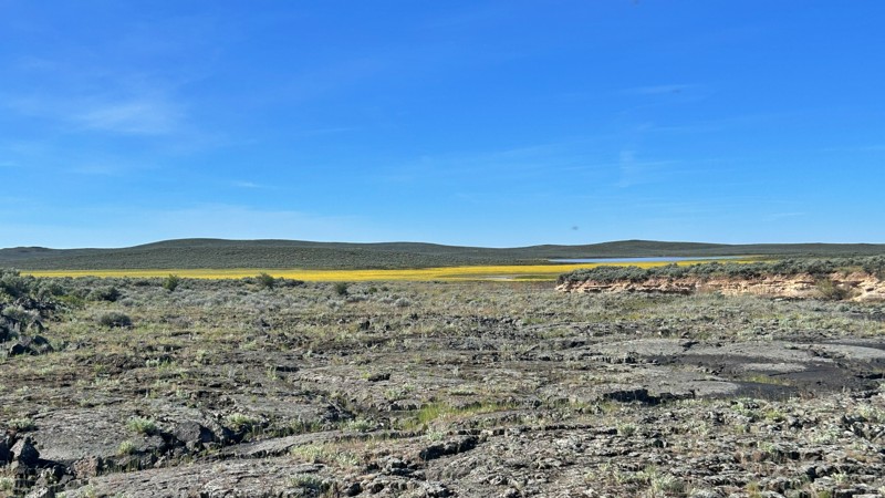
Updated: 05/28/2026
Lower Cow Creek
Jordan Valley, Oregon
Lower Cow Creek Road cuts through a rugged and remote corner of southeastern Oregon, where endless sagebrush plains, volcanic landscapes, and wide-open cattle country stretch to the horizon. The farther north you travel, the more the outside world fades away, replaced by vast basin views, silence, and the feeling of true backcountry isolation. Pronghorn antelope are frequently seen darting across the open desert, while spring and early summer transform the normally dry landscape with colorful wildflowers scattered across the high desert floor.
The Cow Lakes Recreation Area offers a unique mix of remote desert camping and wetland scenery, unlike almost anywhere else in Oregon. A chain of shallow lakes, marshes, and seasonal mudflats creates an ever-changing landscape that draws thousands of migratory birds and wildlife throughout the year. Primitive campsites and roadside pull-offs provide excellent opportunities for dispersed camping with massive sunrise and sunset views, dark night skies, and peaceful solitude far from developed campgrounds. A small boat ramp and a couple of pit toilets provide minimal services while preserving the area’s rugged, undeveloped feel.
One of the most fascinating features of Cow Lakes is the dramatic boundary where ancient black lava flows meet the surrounding high desert basin. Lava from the nearby Jordan Craters eruption blocked historic waterways thousands of years ago, helping create the shallow playa lakes and marsh systems that visitors now explore by fishing, birdwatching, paddleboarding, kayaking, and photography.
The route itself is mostly flat, with a mix of gravel and hard-packed dirt, making it manageable for most high-clearance vehicles in dry conditions. However, this is still remote desert country, and conditions can change quickly after storms or extended rain. Muddy and boggy sections can develop fast, so travelers should come prepared with recovery gear, extra supplies, and the mindset for true overland travel.

Upgrade your Membership
Unlock all of the details on every Trail Guide and Scout Route.
Start a 7-day Free TrialCommunity
Partners