Discovering the Daniel Boone Backcountry Byway and the Red River Gorge Geological Area
Tucked away in the heart of eastern Kentucky, the Red River Gorge Geological Area and the Daniel Boone Backcountry Byway (DBBB) offer unparalleled adventure for offroaders, nature lovers, and outdoor enthusiasts. Stunning geological formations and a scenic yet rugged byway create the perfect combination for a memory-making trip. Not only are there world-class offroad trails to enjoy, but the entire area is filled with adventure that you don’t want to miss.
The Daniel Boone Backcountry Byway: A Scenic and Thrilling Offroad Accomplishment
The Daniel Boone Backcountry Byway (DBBB) is an epic, moderately complex route that utilizes historic county roads around the Red River Gorge and Daniel Boone National Forest in eastern Kentucky. It is touted as over 100 miles in length, but be forewarned, a ⅓ or more of the route is paved, and not all of it is offroading. The route includes several challenging trails, all balanced out with easy gravel roads and paved sections. To drive it all, including the new sections added in 2023, you would want to give yourself three days to really enjoy it and take it all in, but it could be done in two. When planning, keep in mind that most paved roads are traveled at a really slow pace due to their twisty nature and limited passing, so when looking at a map, you can naturally assume you will be moving at a normal speed.
Most of the roads that comprise the Daniel Boone Backcountry Byway are county roads residing in Powell, Estill, Lee, Wolfe, and Menifee Counties. Local groups such as the Southern Four Wheel Drive Association (SFWDA), Ohio River Four Wheelers, Kentucky Toyota Land Cruisers, Kentucky Krawlers, and the Trailkeepers Foundation worked tirelessly with those counties to make this route possible. Since its inception, new trails have been added, and let’s hope they can keep adding.
ATVs and side-by-sides are not allowed; only licensed, registered vehicles can drive the network of trails. Many of the roads are on private property, and it's your responsibility to be a good steward of the land and respect property owners. Following simple etiquette rules helps ensure these roads stay open for generations to come.
1. Always stay on the trail - do not veer from or take side roads.
2. Keep the music and noise levels to a minimum.
3. When coming off a trail and entering back on the pavement, drive slowly to avoid excessive mud and rock evacuation being flung into private residences and other vehicles.
4. Understand that many of the residential areas are in serene countryside settings. Drive slowly and yield to local residents while driving the narrow paved roads.
5. Pack out more than you pack in!
The route is a mix of paved, gravel, and gnarly mountain roads. Depending on your time, skill, and vehicle capabilities, you can choose to drive a specific trail or the entire route. If you want to drive it all, plan out three days to travel at a comfortable pace with plenty of stops, but it could be done in two days.
Dispersed camping is not available on every trail. If you are following the Daniel Boone Backcountry Byway, the DBBB organization points to Spaas Creek as the only trail with dispersed camping, and it is limited. The Trails Offroad Trail Guide does mark the locations for your planning purposes.
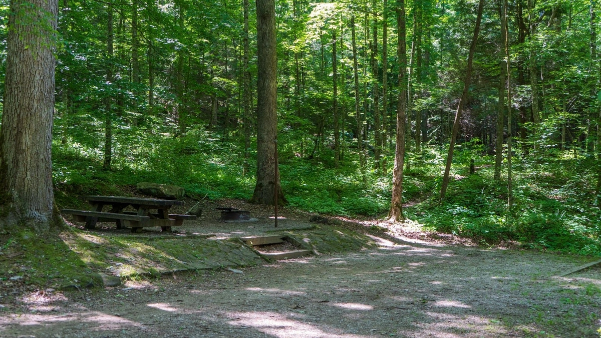
Two National Forest campgrounds on the southwestern end of the route offer designated and somewhat improved camping with a picnic table, fire ring, and vault toilet. These campgrounds are on S-Tree Road and Turkey Foot Road. Additionally, the area is chock-full of private and other National Forest campgrounds that are not directly on the route. Callie’s Lake and Campground, in Slade, is typically the base camp for many offroaders due to its amenities and somewhat central location to all the trails along the Byway, and that is where the Trails Offroad crew stays.
Cabin rentals and small independent motels are also plentiful in the area and easily found through an internet search. Larger towns such as Mount Sterling, north of the Byway, and London, south of the Byway, offer name-brand hotel chains.
Our Top 3 Favorite DBBB Offroad Trails:
The Daniel Boone Backcountry Byway stretches over 100 miles through the lush forests and rolling hills in and around the Daniel Boone National Forest. The byway offers a stunning drive through Kentucky’s most beautiful and untouched landscapes. Expect mud, rock, and water crossings.
1. Spaas Creek
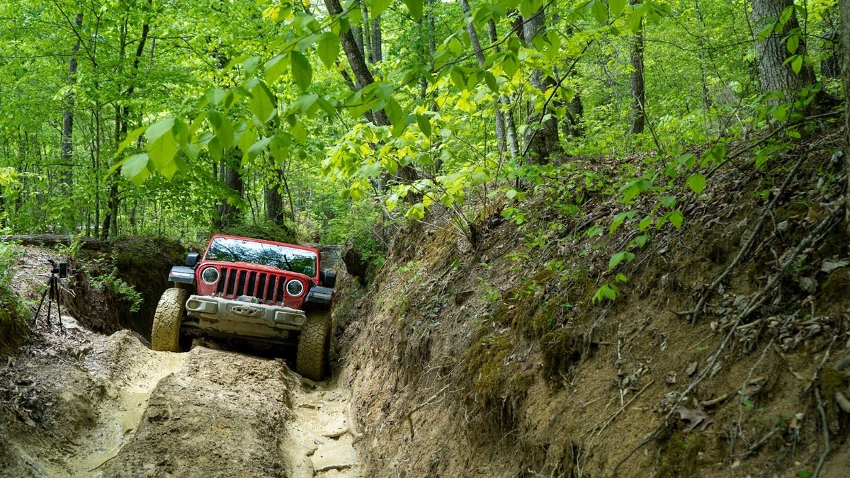
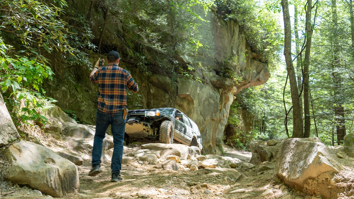
When looking for prime offroad trails in the Red River Gorge Area, look no further than Spaas Creek. It is one of the best offroad trails within the Daniel Boone Backcountry Byway for a good reason - it is satisfying! To satisfy your sense of adventure, it is just tough enough with moderate obstacles to challenge and excite new drivers and provide interest for seasoned drivers. Overlanders love it because it is one of the few trails on the Byway that has dispersed and rustic camping. The wooded wet scenery, which presents new inspiring details around every corner, will captivate even the most cynical in your group. You can't help feeling satisfied after driving Spaas Creek.
2. Pumpkin Hollow
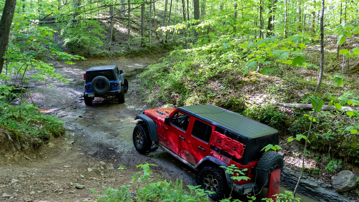
It starts with the name - 'Punkin Hollow' in one county and Pumpkin Hollow in another. Either way you spell it, the Hollow is the quintessential offroad experience of the Red River Gorge region and the Daniel Boone Backcountry Byway. It combines the best features of wheeling in the area without being too stressful and intense. The experience isn't a "gimme" either. You are going to have to earn your hero shots. Slick rocky climbs through a thick, dark green forest will give way to the crossing of the Right Fork Cane Creek. Of all the creek crossings on the Byway, this one is special. You will certainly want your camera crew to get the hero shot of you driving the crossing. Get your wheeling buddies and make it an epic trip by combining Pumpkin Hollow with Spaas Creek
3. Old Fincastle Road
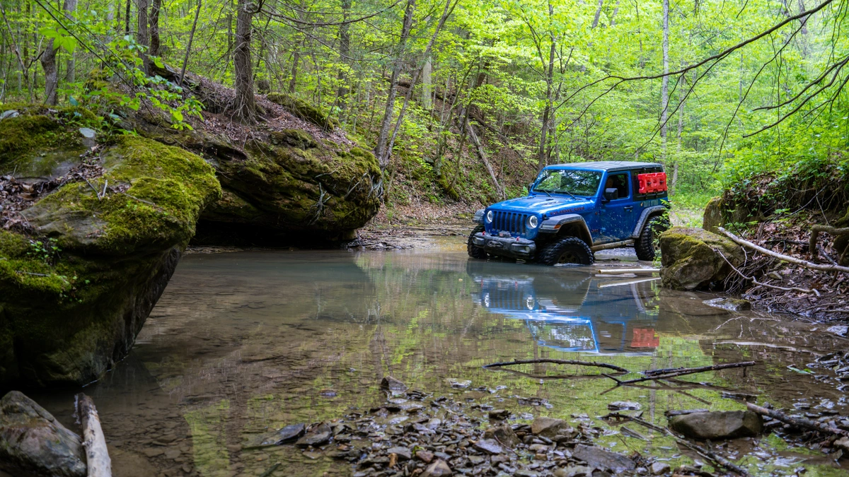
Touted as tough and non-negotiable, Old Fincastle Road is among the few rock-crawling offroad trails when driving the Daniel Boone Backcountry Byway. It's one you don't want to skip. The trail has interesting and exciting features for drivers and passengers alike, from the challenging rock obstacles to a fun, scenic water crossing of Walker Creek. If you are new to rock crawling, this one will pucker you up just enough to inspire you to find more rock crawling trails.
The Red River Gorge Geological Area
After all that wheeling, a leg stretch is welcome and gives you another way to see the landscape that you will not get from behind the steering wheel. The Red River Gorge, a designated National Natural Landmark, is renowned for its impressive array of natural rock formations, including arches, cliffs, and deep gorges. Over millions of years, erosion has sculpted the sandstone and limestone into a dramatic landscape that features natural arches, making it a paradise for hikers and photographers alike. Interestingly, only Utah has more natural bridges and arches than Kentucky, making it truly a unique location in the eastern United States.
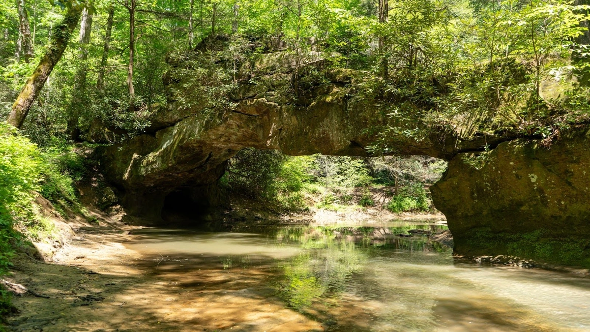
You might be asking yourself what the difference between a bridge and an arch is. A natural bridge and an arch are both geological formations, but they differ in how they are formed. A natural bridge is typically formed by the erosion of water, often over rivers or streams, where flowing water carves out the rock beneath, leaving a bridge-like structure. In contrast, a natural arch is usually formed by wind or chemical weathering that erodes softer rock layers, leaving a freestanding arch. While both are striking landforms, their formation processes reflect the forces of nature that shape them.
Natural Bridge State Park is central to everything and a gateway to a host of adventures. It is home to one of the largest natural arches in the region—the 78-foot-long Natural Bridge. Visitors can hike up to the bridge or take a scenic skylift. The park also offers lodging, a campground, and plenty of picnic spots, making it a great place to relax after a day of adventure.
A few of the top-rated hiking trails that you don't want to miss are:
-
Sky Bridge Trail: A moderate hike that leads to one of the gorge’s most impressive arches, offering panoramic views of the surrounding landscape. .7 miles
-
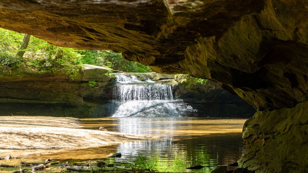
Grays Arch Trail: This 2.3-mile trek is relatively easy and culminates in a stunning arch formation, expansive views of the gorge, and a waterfall.
-
Rock Bridge Trail: A moderate loop hike that takes you to a stunning waterfall and one of the few natural bridges that go over a creek. 1.4 miles long
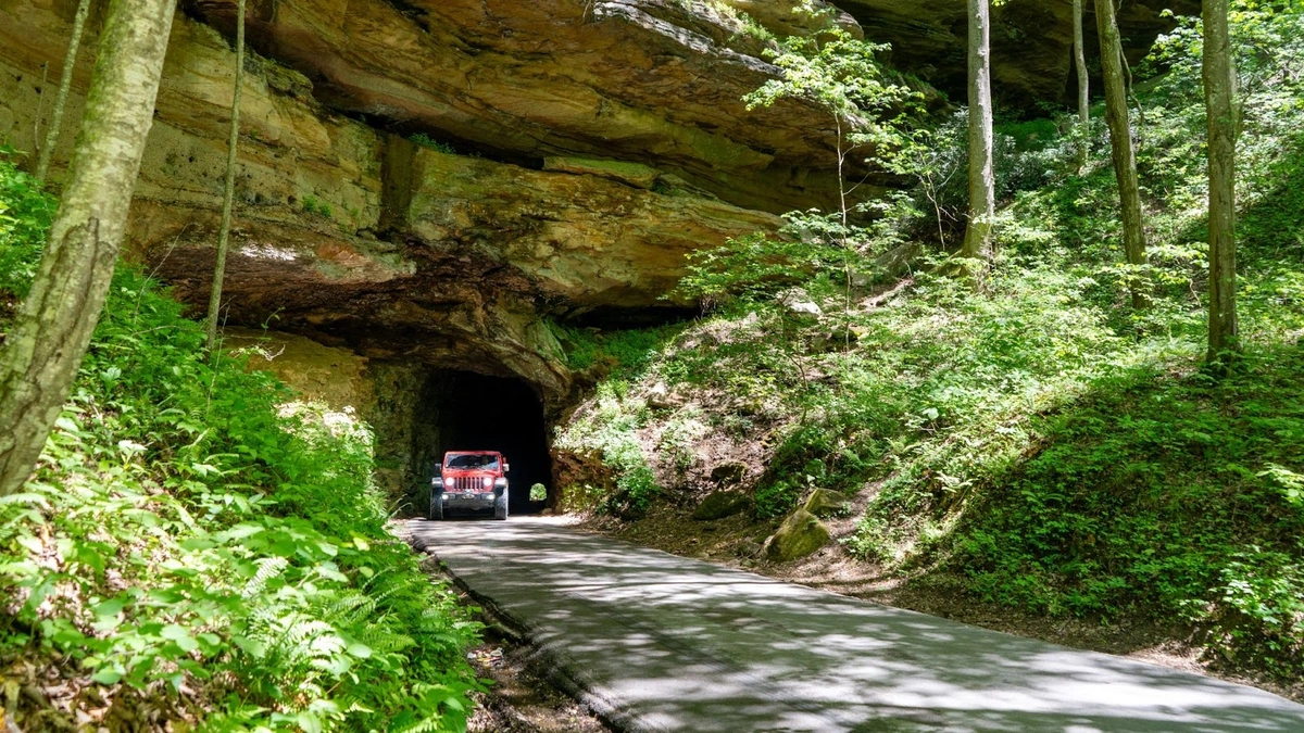
Last but not least, as you drive the DBBB or just explore the area, you are bound to drive through the Nada Tunnel, which is also known as the Gateway to the Red River Gorge. The tunnel is 12’ wide, 13’ high, and 900’ long. It was built by the Dana Lumber Company in the early 1900s and is named after a town that no longer exists, Nada.

Todd is the Founder of Trails Offroad and an avid wheeler who loves to explore new trails whenever and wherever possible. They say necessity is the mother of all invention, which is true for Todd. His want and desire to find passable trails and new nooks and crannies of the Great American west to explore were his reasons behind starting Trails Offroad. On any given day, you can find Todd on an obscure 4x4 trail, curating Trails Offroad guides, or using his legs to hike to an alpine lake.

Community
Partners